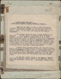
Provided on the front of this two-sided typed document is information regarding the property at the East end of Calhoun Street, known as Gadsden's Wharf. The land ownership is traced back to 1696 under Issac Mazyck. Land development beginning in 1746 under Captain George Anson is also discussed, including the construction of a canal and wharf in Charleston. Changes in street names since the city's early days are also mentioned. A small piece of paper taped to the back reads: "Kindness of: Mr. Gedney M. Howe."
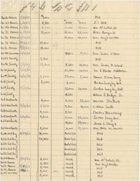
This five-page handwritten document contains information about properties in Ansonborough, including address, owner, kind of building, dimensions, and 1960 assessment.
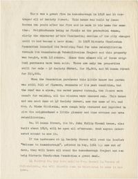
This one-page handwritten document lists numerous properties in the Ansonborough neighborhood on Anson Street, Laurens Street, Society Street, Wentworth Street, and East Bay Street. Informational headings for properties include: date acquired, date sold, purchase price, Foundation Improvements, selling price, purchaser's improvements, and owner.
A one-page typed document chronicling the history of 66 Anson Street, 40 Society Street, and 42 Society Street, from the fire of 1838 to launch of HCF Revolving Fund in 1958.
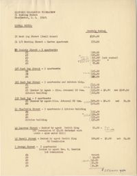
This one-page typed document provides information on rental properties owned by Historic Charleston Foundation. The number of units, comission percentage, and monthly rental costs are included.
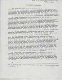
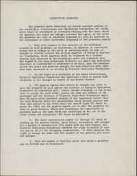
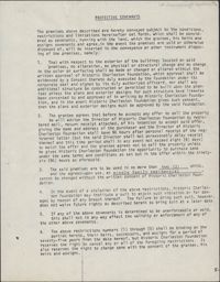
This one-page typed document provides stipulations for properties under the Historic Charleston Foundation's Protective Covenants agreement, prior to 1977 and after 1965.