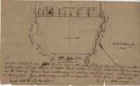
200 acres laid out to Joan Gryce, on the northwest side of Keywaw [Kiawah] Creek in Colleton County, on the left side it is bordered by the Marshes of Bohicket Creek. Names associated with this plat are Joan Gryce and James Witter. Notable geographic locations include Johns Island, Keywaw [Kiawah] Creek, and Bohicket Creek.
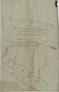
"350 acres granted to Thomas Smith on the 28th March 1694, Bounding [?] On Medway River South on land formerly laid out to Robert Skelton and went north…" Names associated with this plat are Thomas Smith and Robert Skelton.
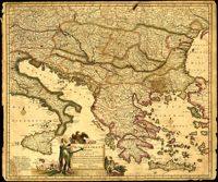
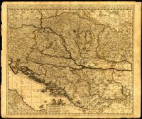
Map by Justus Danckerts (1635-1701) covers the Danube River from Germany to the Black Sea. Depicts all of the Balkans, Hungary, Romania and parts of Austria, Italy and Germany. The map was apparently printed at the height of the Ottoman wars against the European powers in the late seventeenth century. A table in the lower left depicts the names of cities in the Hungarian kingdom that were lost to the Ottomans and when they were recovered to date. The latest date on the table is 1687. However, according to the table, the recapture of Buda (Budapest) took place in 1686 but an examination of Buda on the map reveals a date of 1688. Other known examples of this map include the recovery of Belgrade (Belgrado) in 1688 in the table although this version of the map does not. It is possible this map was printed immediately before the Siege of Belgrade in 1688 or after 1690 when the city was reclaimed by the Turks (and the subsequent reference to Belgrado in the table may have been expunged). Title cartouche depicts a Christian saint and the Hapsburg eagle. Amsterdam. 52 x 62cm.
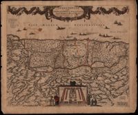
This map was engraved by Frederick de Wit (1630-1706), one of the most prominent and successful publishers in Amsterdam. The Holy Land extends from Sidon and Damascus to the Wilderness of Pharan in the Sinai. The decoration in the map relates to the Old Testament. At the bottom of the map is a depiction of an encampment of the Israelites during Exodus. The Twelve Tribes are around the perimeter and in the center the Tabernacle is illustrated with the Levites in attendance. Moses is at the left holding his staff and his brother Aaron is opposite. The caption in the sea refers to Lebanese cedars being sent by King Hiram of Tyre to King Solomon. The theme of the richness of the Promised Land is emphasized with the beautiful garland supported by the angels across the top, containing fruit, grapes and flowers. North oriented to the right. Amsterdam. 52 x 62cm.
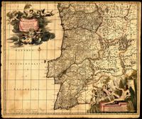
Map of Portugal and Algarve by Johannes de Ram (1648-1693). The title cartouche in the upper left depicts cherubs holding the Portuguese coat of arms; a note within the cartouche explains that the longitudinal lines on the map are based from the prime meridian that runs through Tenerife in the Canary Islands. The scale cartouche in the lower right features Neptune with a trident and two cherubs holding the coat of arms of Algarve, then a semi-autonomous region of Portugal. Amsterdam. 52 x 62cm.
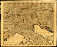
One of three maps by Nicolaes Visscher (1649-1702) collectively showing the entire length of the Danube. This map covers the middle part of the river from Linz through Vienna, Bratislava and Budapest, to just east of Belgrade. Amsterdam. 52 x 62cm.
One of three maps by Nicolaes Visscher (1649-1702) collectively showing the entire length of the Danube. This map depicts the upper Danube from its start in Germany to Bratislava (Presburg on map). Amsterdam. 52 x 62cm.
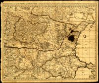
One of three maps by Nicolaes Visscher (1649-1702) collectively showing the entire length of the Danube. This map depicts the lower Danube from Belgrade to its mouth in the Black Sea. Amsterdam. 52 x 62cm.
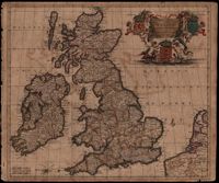
Map of the British Isles by Theodore Danckerts (1663-1727) also includes part of the European coast. The decorative title cartouche is in the upper right corner with putti supporting the shields of Scotland, Ireland and England; the mileage scale is given in the lower left corner. Amsterdam. 52 x 62cm.
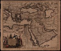
A map of Turkish possessions including Egypt and Greece by Justus Danckerts (1635-1701) shows the Arabian peninsula in the center. A decorative cartouche adorned with several costumed figures, a pyramid, and lions. Amsterdam. 52 x 62cm.