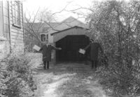
Garage or shed and driveway on site affected by the construction of the Crosstown. Address: 117 Sheppard Street. Surveyor notations on back of photo: "Dkt.: 10.524. Property owner: Julia Sharpe, et al., Est. Tract: 140. Station: 17+65 Rt. N.B. lane. Date: Dec. 2, 1964. Proximity." [See collection description for explanation of surveyor notations.]
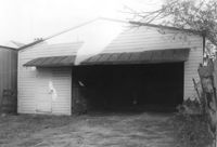
Garage on site affected by the construction of the Crosstown. Address: 508 Rutledge Avenue. Surveyor notations on back of photo: "Dkt.: 10.524. Property owner: W.C. Hayes, Est. Tract: 112. Station: 87±00. Date: Dec. 1, 1964. In R/W - Bought." [See collection description for explanation of surveyor notations.]
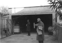
Garage on site affected by the construction of the Crosstown. Address: 510 Rutledge Avenue. Surveyor notations on back of photo: "Dkt.: 10.524. Property owner: George J. Carabates. Tract: 111. Station: 87±05 Lt. Date: Dec. 1, 1964." [See collection description for explanation of surveyor notations.]
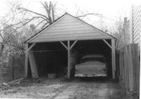
Garage and portion of driveway on site affected by the construction of the Crosstown. Address: 99 Fishburne Street. Surveyor notations on back of photo: "Dkt.: 10.524. Property owner: Richard Wright, et al. Tract: 153. Station: 20+80 Lt. S.B. lane. Date: Dec. 2, 1964." [See collection description for explanation of surveyor notations.]
Right of way--South Carolina--Charleston County, Highway planning--South Carolina--Charleston County, Vernacular architecture--South Carolina--Charleston County, Lost architecture--South Carolina--Charleston County, Dwellings--South Carolina--Charleston County, Garages--South Carolina--Charleston County✖[remove]4