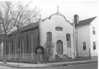
Advent Church of Charleston, on site affected by the construction of Interstate 26 (I-26). Address: 272 St. Philip Street. View of street corner. Surveyor notations on back of photo: "Dkt.: 10.517. Property owner: Advent Church of Charleston. Tract: 115. Station: 25+60 Lt. Southbound Lane Route 17. Date: March 5, 1963. In R/W - Bought." [See collection description for explanation of surveyor notations.]
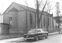
Advent Church of Charleston (corner view, rear), on site affected by the construction of Interstate 26 (I-26). Address: 272 St. Philip Street. Surveyor notations on back of photo: "Dkt.: 10.517. Property owner: Advent Church of Charleston. Tract: 115. Station: 25+60 Lt. Southbound Lane Route 17. Date: March 5, 1963. In R/W - Bought." [See collection description for explanation of surveyor notations.]
Right of way--South Carolina--Charleston County, Highway planning--South Carolina--Charleston County, Vernacular architecture--South Carolina--Charleston County, Lost architecture--South Carolina--Charleston County, Dwellings--South Carolina--Charleston County, Church buildings--South Carolina--Charleston County✖[remove]2