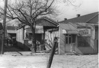
Walker's Grocery and house (behind grocery) on site affected by the construction of Interstate 26 (I-26). Address: 17 Boyer Street. Surveyor notations on back of photo: "Dkt.: 10.503. Property owner: Addie Walker. Tract: 84. Station: 5914+60 Lt. Date: Feb. 20, 1963. In R/W - Bought." [See collection description for explanation of surveyor notations.]
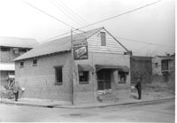
Washington Grocery on site affected by the construction of Interstate 26 (I-26). Address: northeast corner of E Street and C Street. View of street corner. Surveyor notations on back of photo: "Dkt.: 10.517. Property owner: Isaac Washington. Tract: 27. Station: 5946+55 Lt. - Line 6. Date: February 21, 1963." [See collection description for explanation of surveyor notations.]
Right of way--South Carolina--Charleston County, Highway planning--South Carolina--Charleston County, Commercial buildings--South Carolina--Charleston County, Vernacular architecture--South Carolina--Charleston County, Lost architecture--South Carolina--Charleston County, Dwellings--South Carolina--Charleston County, Grocery stores--South Carolina--Charleston County✖[remove]2