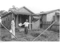
House on site affected by the construction of Interstate 26 (I-26). (See I-26 Photo 1138, rear view.) Surveyor notations on back of photo: "Dkt.: 10.490. Property owner: Nathaniel Phoenix. Tract: 46. Station: 5799+65 Rt. Line 'G'. Date: September 11, 1962. Proximity." [See collection description for explanation of surveyor notations.]
House (rear view) on site affected by the construction of Interstate 26 (I-26). Surveyor notations on back of photo: "Dkt.: 10.490. Property owner: Thomasina Goss. Tract: 47. Station: 5799+90 Rt. Line 'G'. Date: September 11, 1962. Proximity." [See collection description for explanation of surveyor notations.]
House on site affected by the construction of Interstate 26 (I-26). Surveyor notations on back of photo: "Dkt.: 10.490. Property owner: Thomasina Goss. Tract: 47. Station: 5799+90 Rt. Line 'G'. Date: September 11, 1962. Proximity." [See collection description for explanation of surveyor notations.]
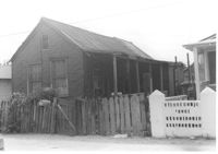
House on site affected by the construction of Interstate 26 (I-26). Surveyor notations on back of photo: "Dkt.: 10.490. Property owner: F.F. Bellinger, et al. Tract: 48. Station: 5800+00 Rt. Line 'G'. Date: September 11, 1962. Proximity." [See collection description for explanation of surveyor notations.]
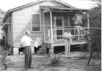
House (rear view) on site affected by the construction of Interstate 26 (I-26). Surveyor notations on back of photo: "Dkt.: 10.490. Property owner: F.F. Bellinger, et al. Tract: 48. Station: 5800+00 Rt. Line 'G'. Date: September 11, 1962. Proximity to rear." [See collection description for explanation of surveyor notations.]
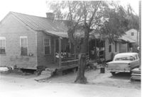
House (rear view), possibly multi-family dwelling, on site affected by the construction of Interstate 26 (I-26). Surveyor notations on back of photo: "Dkt.: 10.490. Property owner: F.F. Bellinger, et al. Tract: 49. Station: 5800+50 Rt. Line 'G'. Date: September 11, 1962. To be cut off at R/W by SCHD [SC Highway Department]." [See collection description for explanation of surveyor notations.]
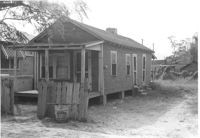
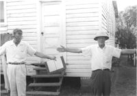
House, possibly multi-family dwelling, on site affected by the construction of Interstate 26 (I-26). Surveyor notations on back of photo: "Dkt.: 10.490. Property owner: F.F. Bellinger, et al. Tract: 49. Station: 5800+50 Rt. Line 'G'. Date: September 11, 1962. To be cut off at R/W by SCHD [SC Highway Department]." [See collection description for explanation of surveyor notations.]
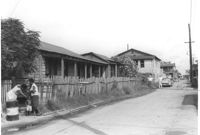
House, possibly multi-family dwelling, on site affected by the construction of Interstate 26 (I-26). View looking up the street. Surveyor notations on back of photo: "Dkt.: 10.490. Property owner: Barbara A. Wright. Tract: 50. Station: 5799+20 Lt. Line 'F'. Date: September 12, 1962. Proximity." [See collection description for explanation of surveyor notations.]
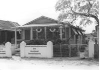
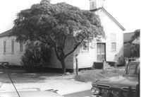
Francis Brown Methodist Church, on site affected by the construction of Interstate 26 (I-26). [2202 Joppa.] Surveyor notations on back of photo: "Dkt.: 10.490. Property owner: Francis Brown Meth. Church. Tract: 51. Station: 5799+50 Lt. Line 'F'. Date: September 12, 1962. Proximity to rear." [See collection description for explanation of surveyor notations.]
Francis Brown Methodist Church (rear view), on site affected by the construction of Interstate 26 (I-26). [2202 Joppa.] Surveyor notations on back of photo: "Dkt.: 10.490. Property owner: Francis Brown Meth. Church. Tract: 51. Station: 5799+50 Lt. Line 'F'. Date: September 12, 1962. Proximity to rear." [See collection description for explanation of surveyor notations.]