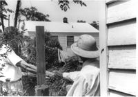
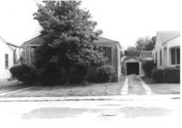
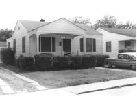
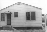
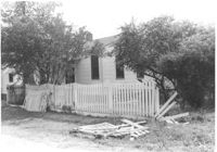
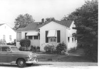
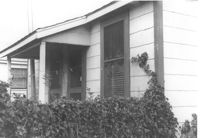
Surveyors clasping hands over fence at rear of house at backyard on site affected by the construction of Interstate 26 (I-26). Address: 2123 Montford Avenue. Surveyor notations on back of photo: "Dkt.: 10.490. Property owner: B.H. Leopard. Tract: 177-A. Station: 135' Lt. Sta. 5886+55. Date: May 15, 1962. Proximity." [See collection description for explanation of surveyor notations.]
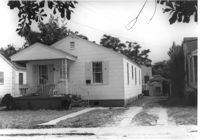
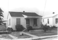
House on site affected by the construction of Interstate 26 (I-26).Address: 2123 Montford Avenue. Surveyor notations on back of photo: "Dkt.: 10.490. Property owner: B.H. Leopard. Tract: 177-A. Station: 135' Lt. Sta. 5886+55. Date: May 15, 1962. Proximity." [See collection description for explanation of surveyor notations.]
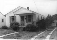
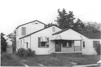
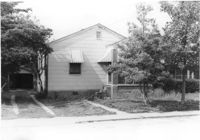
House on site affected by the construction of Interstate 26 (I-26). Address: 2127 Montford Avenue. Surveyor notations on back of photo: "Dkt.: 10.490. Property owner: The Beach Co. Tract: 178. Station: 5886±00 Lt. Date: August 29, 1962. In R/W - Bought." [See collection description for explanation of surveyor notations.]
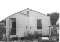
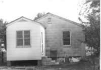
House (corner view, rear) on site affected by the construction of Interstate 26 (I-26). Address: 2127 Montford Avenue. Surveyor notations on back of photo: "Dkt.: 10.490. Property owner: The Beach Co. Tract: 178. Station: 5886±00 Lt. Date: August 29, 1962. In R/W - Bought." [See collection description for explanation of surveyor notations.]
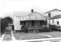
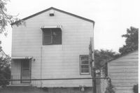
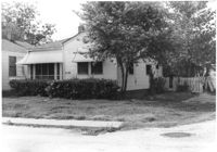
House on site affected by the construction of Interstate 26 (I-26). Address: 2129 Montford Avenue. Surveyor notations on back of photo: "Dkt.: 10.490. Property owner: Edw. H. Heuer, Jr. [Edward H. Heuer, Jr.]. Tract: 179. Station: 5886+00 Lt. Date: May 15, 1962. In R/W - Bought." [See collection description for explanation of surveyor notations.]
House (rear view) on site affected by the construction of Interstate 26 (I-26).Address: 2129 Montford Avenue. Surveyor notations on back of photo: "Dkt.: 10.490. Property owner: Edw. H. Heuer, Jr. [Edward H. Heuer, Jr.]. Tract: 179. Station: 5886+00 Lt. Date: May 15, 1962. In R/W - Bought." [See collection description for explanation of surveyor notations.]
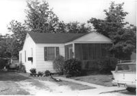
House on site affected by the construction of Interstate 26 (I-26). Address: 2131 Montford Avenue. Surveyor notations on back of photo: "Dkt.: 10.490. Property owner: Mrs. Edna L. Viard. Tract: 180. Station: 5885+70 on CL. Date: May 15, 1962. In R/W - Bought." [See collection description for explanation of surveyor notations.]
House (rear view) on site affected by the construction of Interstate 26 (I-26). Address: 2131 Montford Avenue. Surveyor notations on back of photo: "Dkt.: 10.490. Property owner: Mrs. Edna L. Viard. Tract: 180. Station: 5885+70 on CL. Date: May 15, 1962. In R/W - Bought." [See collection description for explanation of surveyor notations.]
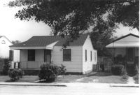
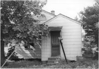
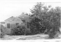
House on site affected by the construction of Interstate 26 (I-26).Address: 2133 Montford Avenue. Front of house almost completely obscured by trees. Surveyor notations on back of photo: "Dkt.: 10.490. Property owner: Floyd R. Wohnig. Tract: 181. Station: 5885+55 Rt. Date: May 15, 1962. In R/W - Bought." [See collection description for explanation of surveyor notations.]
House (corner view, rear) on site affected by the construction of Interstate 26 (I-26). Address: 2133 Montford Avenue. Surveyor notations on back of photo: "Dkt.: 10.490. Property owner: Floyd R. Wohnig. Tract: 181. Station: 5885+55 Rt. Date: May 15, 1962. In R/W - Bought." [See collection description for explanation of surveyor notations.]
House (rear view) on site affected by the construction of Interstate 26 (I-26). Address: 2135 Montford Avenue. Surveyor notations on back of photo: "Dkt.: 10.490. Property owner: Paul E. West. Tract: 182. Station: 60'Rt. Sta. 5885+50. Date: May 15, 1962. In R/W - Bought." [See collection description for explanation of surveyor notations.]
House on site affected by the construction of Interstate 26 (I-26). Address: 2135 Montford Avenue. Surveyor notations on back of photo: "Dkt.: 10.490. Property owner: Paul E. West. Tract: 182. Station: 60'Rt. Sta. 5885+50. Date: May 15, 1962. In R/W - Bought. Storage house to be retained by owner." [See collection description for explanation of surveyor notations.]
House on site affected by the construction of Interstate 26 (I-26). Address: 2135 Montford Avenue. Surveyor notations on back of photo: "Dkt.: 10.490. Property owner: Paul E. West. Tract: 182. Station: 60'Rt. Sta. 5885+50. Date: May 15, 1962. In R/W - Bought. Storage house to be retained by owner." [See collection description for explanation of surveyor notations.]
House on site affected by the construction of Interstate 26 (I-26). Address: 2137 Montford Avenue. Surveyor notations on back of photo: "Dkt.: 10.490. Property owner: Joseph E. Aldret. Tract: 183. Station: 100' Rt. Sta. 5885+30. Date: May 15, 1962. In R/W - Bought." [See collection description for explanation of surveyor notations.]
House (rear view) on site affected by the construction of Interstate 26 (I-26). Address: 2137 Montford Avenue. Surveyor notations on back of photo: "Dkt.: 10.490. Property owner: Joseph E. Aldret. Tract: 183. Station: 100' Rt. Sta. 5885+30. Date: May 15, 1962. In R/W - Bought." [See collection description for explanation of surveyor notations.]
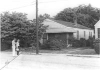
House (rear view) on site affected by the construction of Interstate 26 (I-26). Address: 2132 Weaver Avenue. Surveyor notations on back of photo: "Dkt.: 10.490. Property owner: Alvin C. Jervey. Tract: 184. Station: 120' Rt. Sta. 5886+50. Date: May 15, 1962. Proximity." [See collection description for explanation of surveyor notations.]
House on site affected by the construction of Interstate 26 (I-26). Address: 2132 Weaver Avenue. Surveyor notations on back of photo: "Dkt.: 10.490. Property owner: Alvin C. Jervey. Tract: 184. Station: 120' Rt. Sta. 5886+50. Date: May 15, 1962. Proximity." [See collection description for explanation of surveyor notations.]
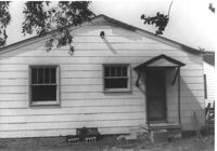
House on site affected by the construction of Interstate 26 (I-26). Address: 2130 Weaver Avenue. Surveyor notations on back of photo: "Dkt.: 10.490. Property owner: Chas. R. Rentiers [Charles R. Rentiers]. Tract: 185. Station: 80' Rt. Sta. 5886+65. Date: May 15, 1962. Proximity." [See collection description for explanation of surveyor notations.]
House (rear view) on site affected by the construction of Interstate 26 (I-26). Address: 2130 Weaver Avenue. Surveyor notations on back of photo: "Dkt.: 10.490. Property owner: Chas. R. Rentiers [Charles R. Rentiers]. Tract: 185. Station: 80' Rt. Sta. 5886+65. Date: May 15, 1962. Proximity." [See collection description for explanation of surveyor notations.]
House on site affected by the construction of Interstate 26 (I-26). Address: 2128 Weaver Avenue. Surveyor notations on back of photo: "Dkt.: 10.490. Property owner: Amile C. West. Tract: 186. Station: 40' Rt. Sta. 5886+70. Date: May 15, 1962. In R/W - Bought." [See collection description for explanation of surveyor notations.]
House (rear view) on site affected by the construction of Interstate 26 (I-26). Address: 2128 Weaver Avenue. Surveyor notations on back of photo: "Dkt.: 10.490. Property owner: Amile C. West. Tract: 186. Station: 40' Rt. Sta. 5886+70. Date: May 15, 1962. In R/W - Bought." [See collection description for explanation of surveyor notations.]
House on site affected by the construction of Interstate 26 (I-26). Address: 2126 Weaver Avenue. Surveyor notations on back of photo: "Dkt.: 10.490. Property owner: J.L. Duffy. Tract: 187. Station: 5887±00 Rt. Date: August 29, 1962. In R/W - Bought." [See collection description for explanation of surveyor notations.]
House (rear view) on site affected by the construction of Interstate 26 (I-26). Address: 2126 Weaver Avenue. Surveyor notations on back of photo: "Dkt.: 10.490. Property owner: J.L. Duffy. Tract: 187. Station: 5887±00 Rt. Date: August 29, 1962. In R/W - Bought." [See collection description for explanation of surveyor notations.]
House on site affected by the construction of Interstate 26 (I-26). Address: 2124 Weaver Avenue. Surveyor notations on back of photo: "Dkt.: 10.490. Property owner: Harry L. Rumph, Jr. Tract: 188. Station: 5887+20 on CL. Date: May 15, 1962. In R/W - Bought." [See collection description for explanation of surveyor notations.]
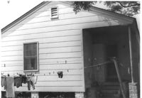
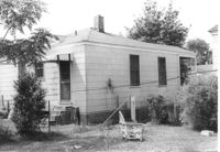
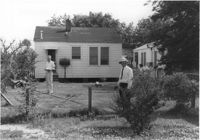
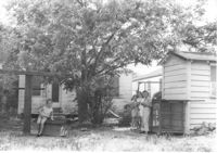
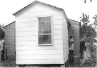
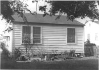
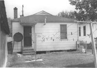
House (rear view) and yard with children "hanging out," on site affected by the construction of Interstate 26 (I-26). Address: 2124 Weaver Avenue. Surveyor notations on back of photo: "Dkt.: 10.490. Property owner: Harry L. Rumph, Jr. Tract: 188. Station: 5887+20 on CL. Date: May 15, 1962. In R/W - Bought." [See collection description for explanation of surveyor notations.]
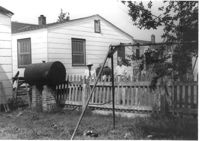
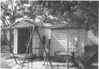
Two sheds and swing set, with standing girl, on site affected by the construction of Interstate 26 (I-26). Address: 2124 Weaver Avenue. Surveyor notations on back of photo: "Dkt.: 10.490. Property owner: Harry L. Rumph, Jr. Tract: 188. Station: 30' Lt. Sta. 5886-55. Date: May 15, 1962. In R/W - Bought." [See collection description for explanation of surveyor notations.]
House on site affected by the construction of Interstate 26 (I-26). Address: 2124 Weaver Avenue. Surveyor notations on back of photo: "Dkt.: 10.490. Property owner: Harry L. Rumph, Jr. Tract: 188. Station: 5887±00 Lt. Date: August 29, 1962. In R/W - Bought." [See collection description for explanation of surveyor notations.]
House (rear view) on site affected by the construction of Interstate 26 (I-26). Address: 2124 Weaver Avenue. Surveyor notations on back of photo: "Dkt.: 10.490. Property owner: Harry L. Rumph, Jr. Tract: 188. Station: 5887±00 Lt. Date: August 29, 1962. In R/W - Bought." [See collection description for explanation of surveyor notations.]
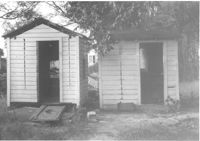
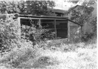
Two sheds on site affected by the construction of Interstate 26 (I-26).Address: 2124 Weaver Avenue. Surveyor notations on back of photo: "Dkt.: 10.490. Property owner: Harry L. Rumph, Jr. Tract: 188. Station: 5887±00 Lt. Date: August 29, 1962. In R/W - Bought." [See collection description for explanation of surveyor notations.]
House on site affected by the construction of Interstate 26 (I-26). Address: 2122 Weaver Avenue. View of house partially obscured by trees. Surveyor notations on back of photo: "Dkt.: 10.490. Property owner: Ola C. Verdier [Olar C. Verdier?]. Tract: 189. Station: 35' Lt. Sta. 5887+45. Date: May 15, 1962. In R/W - Bought." [See collection description for explanation of surveyor notations.]
House (rear view) on site affected by the construction of Interstate 26 (I-26). Address: 2122 Weaver Avenue. Surveyor notations on back of photo: "Dkt.: 10.490. Property owner: Olar C. Verdier [Ola C. Verdier]. Tract: 189. Station: 35' Lt. Sta. 5887+45. Date: May 15, 1962. In R/W - Bought." [See collection description for explanation of surveyor notations.]
House on site affected by the construction of Interstate 26 (I-26). Address: 2120 Weaver Avenue. Surveyor notations on back of photo: "Dkt.: 10.490. Property owner: Troy R. Bevill. Tract: 190. Station: 65' Lt. Sta. 5887+55. Date: May 15, 1962. In R/W - Bought." [See collection description for explanation of surveyor notations.]
House (rear view) on site affected by the construction of Interstate 26 (I-26). Address: 2120 Weaver Avenue. Surveyor notations on back of photo: "Dkt.: 10.490. Property owner: Troy R. Bevill. Tract: 190. Station: 65' Lt. Sta. 5887+55. Date: May 15, 1962. In R/W - Bought." [See collection description for explanation of surveyor notations.]
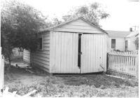
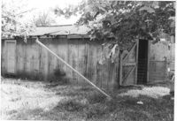
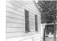
Shed on site affected by the construction of Interstate 26 (I-26). Address: 2120 Weaver Avenue. Surveyor notations on back of photo: "Dkt.: 10.490. Property owner: Troy R. Bevill. Tract: 190. Station: 100' Lt. Sta. 5887+00. Date: May 15, 1962. In R/W - Bought." [See collection description for explanation of surveyor notations.]
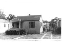
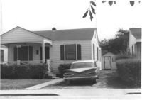
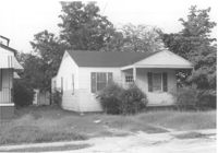
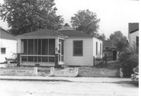
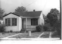
House on site affected by the construction of Interstate 26 (I-26). Address: 2119 Weaver Avenue. Surveyor notations on back of photo: "Dkt.: 10.490. Property owner: Marion Butler, et al. Tract: 192. Station: 5888+50 on CL. Date: May 15, 1962. In R/W - Bought." [See collection description for explanation of surveyor notations.]
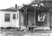
House (rear view) on site affected by the construction of Interstate 26 (I-26). Address: 2119 Weaver Avenue. Surveyor notations on back of photo: "Dkt.: 10.490. Property owner: Marion Butler, et al. Tract: 192. Station: 5888+50 on CL. Date: May 15, 1962. In R/W - Bought." [See collection description for explanation of surveyor notations.]
Bird house on site affected by the construction of Interstate 26 (I-26). Address: 2117 Weaver Avenue. See also I-26 Photos 1448-1449. Surveyor notations on back of photo: "Dkt.: 10.490. Property owner: Mrs. Lucretia Nowak. Tract: 191. Station: 5888+85 Lt. House, 5889+23 on CL Bird House. Date: May 15, 1962. In R/W - Bought." [See collection description for explanation of surveyor notations.]
Outbuilding on site affected by the construction of Interstate 26 (I-26). Address: 2117 Weaver Avenue. See also I-26 Photos 1448-1449. Surveyor notations on back of photo: "Dkt.: 10.490. Property owner: Marion Butler, et al. Tract: 192. Station: 5888+80 Rt. Date: May 15, 1962. In R/W - Bought." [See collection description for explanation of surveyor notations.]
House on site affected by the construction of Interstate 26 (I-26). Address: 2121 Weaver Avenue. Surveyor notations on back of photo: "Dkt.: 10.490. Property owner: Peter Putz. Tract: 193. Station: 5888+30 Rt. Date: May 15, 1962. In R/W - Bought." [See collection description for explanation of surveyor notations.]
House (rear view) on site affected by the construction of Interstate 26 (I-26). Address: 2121 Weaver Avenue. Surveyor notations on back of photo: "Dkt.: 10.490. Property owner: Peter Putz. Tract: 193. Station: 5888+30 Rt. Date: May 15, 1962. In R/W - Bought." [See collection description for explanation of surveyor notations.]
House on site affected by the construction of Interstate 26 (I-26). Address: 2117 Weaver Avenue. See also I-26 Photos 144-1445. View of house partially obscured by trees and bushes. See also I-26 Photo 1444. Surveyor notations on back of photo: "Dkt.: 10.490. Property owner: Mrs. Lucretia Nowak. Tract: 191. Station: 5888+85 Lt. Date: May 15, 1962. In R/W - Bought." [See collection description for explanation of surveyor notations.]
House (rear view) on site affected by the construction of Interstate 26 (I-26). Address: 2117 Weaver Avenue. See also I-26 Photos 1444-1445. Surveyor notations on back of photo: "Dkt.: 10.490. Property owner: Mrs. Lucretia Nowak. Tract: 191. Station: 5888+85 Lt. Date: May 15, 1962. In R/W - Bought." [See collection description for explanation of surveyor notations.]
House on site affected by the construction of Interstate 26 (I-26). Address: 2123 Weaver Avenue. Surveyor notations on back of photo: "Dkt.: 10.490. Property owner: Henry Yaschik. Tract: 194. Station: 5888+10 Rt. Date: May 15, 1962. In R/W - Bought." [See collection description for explanation of surveyor notations.]
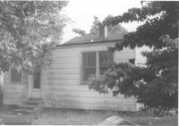
House (rear view) on site affected by the construction of Interstate 26 (I-26). Address: 2123 Weaver Avenue. Surveyor notations on back of photo: "Dkt.: 10.490. Property owner: Henry Yaschik. Tract: 194. Station: 5888+10 Rt. Date: May 15, 1962. In R/W - Bought." [See collection description for explanation of surveyor notations.]
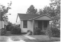
House on site affected by the construction of Interstate 26 (I-26). Address: 2125 Weaver Avenue. Surveyor notations on back of photo: "Dkt.: 10.490. Property owner: Rob't O. Davey [Robert O. Davey]. Tract: 195. Station: 80' Rt. Sta. 5887+90. Date: May 15, 1962. In R/W - Bought." [See collection description for explanation of surveyor notations.]
House (rear view) on site affected by the construction of Interstate 26 (I-26). Address: 2125 Weaver Avenue. Surveyor notations on back of photo: "Dkt.: 10.490. Property owner: Rob't O. Davey [Robert O. Davey]. Tract: 195. Station: 80' Rt. Sta. 5887+90. Date: May 15, 1962. In R/W - Bought." [See collection description for explanation of surveyor notations.]
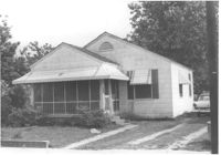
House on site affected by the construction of Interstate 26 (I-26). Address: 2127 Weaver Avenue. View of house partially obscured by trees and bushes. Surveyor notations on back of photo: "Dkt.: 10.490. Property owner: John B. Priester, Jr. Tract: 196. Station: 115' Rt. Sta. 5887+70. Date: May 15, 1962. Proximity." [See collection description for explanation of surveyor notations.]
House on site affected by the construction of Interstate 26 (I-26). Address: 2129 Weaver Avenue. Surveyor notations on back of photo: "Dkt.: 10.490. Property owner: Lewis W. Infinger, Est. Tract: 197. Sta.: 110' Rt. Sta. 5889+25. Date: May 15, 1962. In R/W - Bought." [See collection description for explanation of surveyor notations.]
House (rear view) on site affected by the construction of Interstate 26 (I-26). Address: 2129 Weaver Avenue. Surveyor notations on back of photo: "Dkt.: 10.490. Property owner: Lewis W. Infinger, Est. Tract: 197. Sta.: 110' Rt. Sta. 5889+25. Date: May 15, 1962. In R/W - Bought." [See collection description for explanation of surveyor notations.]
House (rear view) on site affected by the construction of Interstate 26 (I-26). Address: 2124 Mt. Pleasant Street (possibly). Surveyor notations on back of photo: "Dkt.: 10.490. Property owner: Mrs. Barbara Hendricks. Tract: 197-A. Station: 130' Rt. Sta. 5889+00. Date: May 15, 1962. Proximity." [See collection description for explanation of surveyor notations.]