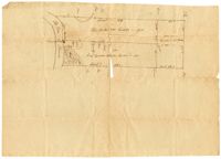
A hand-drawn map of land along the Pee Dee River which records the original land grants from 1711 The land of Thomas Diston and Lady Elizabeth Drake is marked, as well as swamp land and Tapsaw Plantation
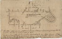
Plat of land laid out to Huggins of 58 acres situated on the NE side of Pee Dee River butting and bounding to the North on William Alston's land and to the south and southwest on unknown land. Names associated with this plat are Huggins, William Alston, Job Roshmahler and John Hardwick.
Copy of a plat of 765 acres of high land and swamp and 98 acres of swamp along Pee Dee River. Names associated with this plat are Colonel Powell, Saxby, Richfield, Wood Furman and Broughton. Notable geographic locations include St. George Parish, the Pee Dee River, Churning Crop Road, Richfield Plantation, and Georgetown District.