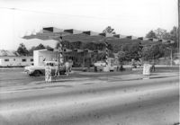
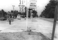
Kayo gas station, on site affected by the widening of State Road 13 (Remount Road). Surveyor notations on back of photo: "Dkt.: 10.562. Property owner: S.R. Hill - K.O. Station. Tract: 66. Date: Jul. 19, 1967." [See collection description for explanation of surveyor notations.]
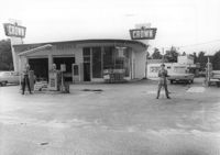
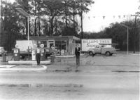
Crown gas station, on site affected by the widening of State Road 13 (Remount Road). Possibly the corner of North Rhett Avenue and Remount Road. Surveyor notations on back of photo: "Dkt.: 10.562. Property owner: Corco Realty Co. (Crown). Tract: 142. Date: Jul. 19, 1967." [See collection description for explanation of surveyor notations.]
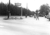
Crown gas station, on site affected by the widening of State Road 13 (Remount Road). View of street corner. Possibly the corner of North Rhett Avenue and Remount Road. Surveyor notations on back of photo: "Dkt.: 10.562. Property owner: Corco Realty Co. (Crown). Tract: 142. Date: Jul. 19, 1967." [See collection description for explanation of surveyor notations.]
Kayo gas station, on site affected by the widening of State Road 13 (Remount Road). Surveyor notations on back of photo: "Dkt.: 10.562. Property owner: S.R. Hill - K.O. Station. Tract: 66. Date: Jul. 19, 1967." [See collection description for explanation of surveyor notations.]
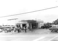
Texaco gas station, on site affected by the widening of State Road 13 (Remount Road). Neighboring Gulf gas Station: in background. Surveyor notations on back of photo: "Dkt.: 10.562. Property owner: W.L. Dyches, et al. Tract: 23. Date: Jul. 12, 1967." [See collection description for explanation of surveyor notations.]
Spar gas station, on site affected by the widening of Route 171 (Folly Road). Surveyor notations on back of photo: "Dkt.: 10.494. Property owner: Palm Oil Co. Tract: 45. Station: 176+80 Lt. Date: Mar. 21, 1962. Owner to move pumps. [See collection description for explanation of surveyor notations.]
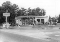
Atlantic gas station, on site affected by the widening of State Road 13 (Remount Road). Surveyor notations on back of photo: "Dkt.: 10.562. Property owner: Atlantic Refining Co. Tract: 37. Date: Jul. 19, 1967." [See collection description for explanation of surveyor notations.]
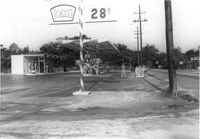
Gulf gas station, on site affected by the widening of Route 171 (Folly Road). Surveyor notations on back of photo: "Dkt.: 10.494. Property owner: Tremarco Corp. Tract: 46. Station: 178+90 Rt. Date: Mar. 21, 1962. Owner to move pumps. [See collection description for explanation of surveyor notations.]
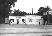
Humble gas station / Esso gas station on site affected by the widening of U.S. Route 17. Ed Cummings, proprietor. Presumably located in Mount Pleasant or vicinity. Surveyor notations on back of photo: "Dkt.: 10.597. Property owner: Edward Cummings. Tract: 37. Station: 285+20 Lt. Date: Sept. 17, 1968." [See collection description for explanation of surveyor notations.]
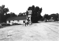
Phillips 66 gas station on site affected by the widening of U.S. Route 17. Gulf gas station in background. Presumably located in southern Charleston County. Surveyor notations on back of photo: "Dkt.: 10.600. Property owner: Nora Bishop Carmichael. Tract: 18. Station: 608±40 Lt. Date: Sept. 18, 1968." [See collection description for explanation of surveyor notations.]
Right of way--South Carolina--Charleston County, Highway planning--South Carolina--Charleston County, Commercial buildings--South Carolina--Charleston County, Service stations--South Carolina--Charleston County, Vernacular architecture--South Carolina--Charleston County, Lost architecture--South Carolina--Charleston County✖[remove]51
Charleston County (S.C.)--Buildings, structures, etc.✖[remove]51