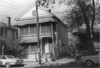
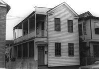
House on site affected by the construction of the Crosstown. Address: 128 Sheppard Street. Surveyor notations on back of photo: "Dkt.: 10.524. Property owner: Kawarsuan, Inc. Tract: 133. Station: 16+40 Lt. S.B. lane. Date: Dec. 2, 1964. Condemned." [See collection description for explanation of surveyor notations.]
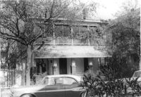
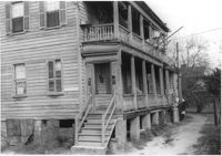
House on site affected by the construction of the Crosstown. Address: 130 Sheppard Street. Surveyor notations on back of photo: "Dkt.: 10.524. Property owner: Charles J. Brendt. Tract: 132. Station: 91+90 Lt. Date: Dec. 2, 1964. In R/W - Bought." [See collection description for explanation of surveyor notations.]
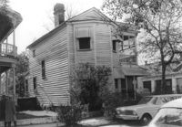
House on site affected by the construction of the Crosstown. Address: 127 Sheppard Street. Surveyor notations on back of photo: "Dkt.: 10.524. Property owner: Essie W. Jenkins. Tract: 129. Station: 91+50 Rt. Date: Dec. 2, 1964. In R/W - Bought." [See collection description for explanation of surveyor notations.]
House on site affected by the construction of the Crosstown. Address: 130 Sheppard Street. Surveyor notations on back of photo: "Dkt.: 10.524. Property owner: Charles J. Brendt. Tract: 132. Station: 91+90 Lt. Date: Dec. 2, 1964. In R/W - Bought." [See collection description for explanation of surveyor notations.]
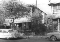
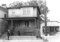
House on site affected by the construction of the Crosstown. Address: 114 Bogard Street. Surveyor notations on back of photo: "Dkt.: 10.524. Property owner: Francis Jenkins, et al. Tract: 64. Station: 75+70 CL Rt. Date: Oct. 14, 1964. In R/W - Bought." [See collection description for explanation of surveyor notations.]
House on site affected by the construction of the Crosstown. Address: 190 Spring Street. Surveyor notations on back of photo: "Dkt.: 10.524. Property owner: E.H. Heidman, Est. Tract: 18. Station: 24± Lt. (Spring Street). Date: Oct. 13, 1964. Portion in R/W to be removed." [See collection description for explanation of surveyor notations.]
House on site affected by the construction of the Crosstown. Address: 22 Wescott Street. Surveyor notations on back of photo: "Dkt.: 10.524. Property owner: Ida J. Gantt. Tract: 10. Station: 61+20 Lt. Date: Oct. 13, 1964." [See collection description for explanation of surveyor notations.]
Right of way--South Carolina--Charleston County, Highway planning--South Carolina--Charleston County, Vernacular architecture--South Carolina--Charleston County, Lost architecture--South Carolina--Charleston County, Dwellings--South Carolina--Charleston County✖[remove]287