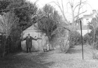
Shed and backyard on site affected by the construction of the Crosstown. Address: 112 Sheppard Street. Surveyor notations on back of photo: "Dkt.: 10.524. Property owner: Alston O. Crum, Est. Tract: 146. Station: 19+60 Lt. S.B. lane. Date: Dec. 2, 1964. Proximity." [See collection description for explanation of surveyor notations.]
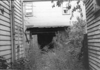
Shed in rear of house, on site affected by the construction of the Crosstown. Address: 11 Kennedy Street. Surveyor notations on back of photo: "Dkt.: 10.524. Property owner: J. Arthur Brown. Tract: 87. Station: 80+45 Rt. Date: Oct. 14, 1964. Behind house." [See collection description for explanation of surveyor notations.]
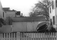
Shed and/or garage and yard on site affected by the construction of the Crosstown. Address: 285 Coming Street. Surveyor notations on back of photo: "Dkt.: 10.524. Property owner: Gladys S. Wilson. Tract: 151. Station: 21+00 Rt. S.B. lane. Date: Dec. 2, 1964. In R/W - Bought." [See collection description for explanation of surveyor notations.]
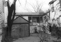
Storage shed or garage and backyard in rear of house on site affected by the construction of the Crosstown. Address: 160½ Line Street [160 Line Street]. Surveyor notations on back of photo: "Dkt.: 10.524. Property owner: John Meyer, Est. Tract: 101. Station: 83+65 Lt. Date: Dec. 1, 1964. In R/W - Bought." [See collection description for explanation of surveyor notations.]
Limit your search
SCDOT Photographs: Properties in the Right-of-Way✖[remove]4
Right of way--South Carolina--Charleston County, Highway planning--South Carolina--Charleston County, Vernacular architecture--South Carolina--Charleston County, Lost architecture--South Carolina--Charleston County, Dwellings--South Carolina--Charleston County, Outbuildings--South Carolina--Charleston County✖[remove]4