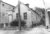
House (freedman's cottage) on site affected by the construction of the Crosstown. Address: 7 Rosemont Street. Surveyor notations on back of photo: "Dkt.: 10.524. Property owner: Lauretta Izzard. Tract: 52. Station: 72+70 Rt. Date: Oct. 14, 1964. In R/W - Bought." [See collection description for explanation of surveyor notations.]
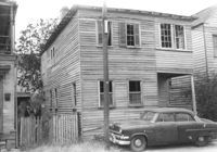
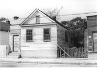
House on site affected by the construction of the Crosstown. Address: 13 Kennedy Street. Surveyor notations on back of photo: "Dkt.: 10.524. Property owner: Frances B. Beaton, Est. Tract: 86. Station: 80+35 Rt. Date: Oct. 14, 1964. In R/W - Bought." [See collection description for explanation of surveyor notations.]
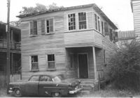
House on site affected by the construction of the Crosstown. Address: 13 Kennedy Street. Surveyor notations on back of photo: "Dkt.: 10.524. Property owner: Frances B. Beaton, Est. Tract: 86. Station: 80+35 Rt. Date: Oct. 14, 1964. In R/W - Bought." [See collection description for explanation of surveyor notations.]
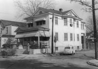
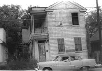
House on site affected by the construction of the Crosstown. Address: 270 Ashley Avenue. View of street corner. Surveyor notations on back of photo: "Dkt.: 10.524. Property owner: J. Arthur Brown. Tract: 90. Station: 80+50 Lt. Date: Dec. 1, 1964." [See collection description for explanation of surveyor notations.]
House (rear view) on site affected by the construction of the Crosstown. Address: 162A Cannon Street (address on 1951 Sanborn Map). Surveyor notations on back of photo: "Dkt.: 10.524. Property owner: J. Irvine Hoffman. Tract: 6. Station: 61+60 Rt. Date: Oct. 13, 1964. In R/W - Bought." [See collection description for explanation of surveyor notations.]
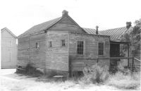
House on site affected by the construction of the Crosstown. Address: 106 Bogard Street. Surveyor notations on back of photo: "Dkt.: 10.524. Property owner: Charity Freeman. Tract: 73. Station: 76+90 Rt. Date: Oct. 14, 1964. Proximity." [See collection description for explanation of surveyor notations.]
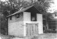
Cinder block structure (garage?) on site affected by the construction of the Crosstown. Address: 110 Bogard Street. Surveyor notations on back of photo: "Dkt.: 10.524. Property owner: Thomassina Elizabeth McCray. Tract: 72. Station: 76+60 Rt. Date: Oct. 14, 1964. In R/W - Bought." [See collection description for explanation of surveyor notations.]
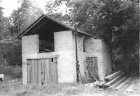
Cinder block structure (garage?) on site affected by the construction of the Crosstown. Address: 110 Bogard Street. Surveyor notations on back of photo: "Dkt.: 10.524. Property owner: Thomassina Elizabeth McCray. Tract: 72. Station: 76+60 Rt. Date: Oct. 14, 1964. In R/W - Bought." [See collection description for explanation of surveyor notations.]
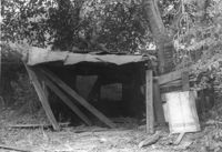
Structure (shed?) in dilapidated condition on site affected by the construction of the Crosstown. Address: 79 Kracke Street. Surveyor notations on back of photo: "Dkt.: 10.524. Property owner: Ella Lawrence, Est. Tract: 70. Station: 77+30 Lt. Date: Oct. 14, 1964. In R/W - Bought." [See collection description for explanation of surveyor notations.]
House on site affected by the construction of the Crosstown. Address: 162B Cannon Street (address on 1951 Sanborn Map). Surveyor notations on back of photo: "Dkt.: 10.524. Property owner: J. Irvine Hoffman. Tract: 5. Station: 61+40 Rt. Date: Oct. 13, 1964. In R/W - Bought." [See collection description for explanation of surveyor notations.]