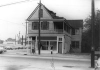
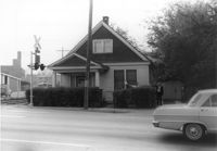
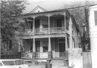
House on site affected by the construction of Interstate 26 (I-26). Address: 1226 King Street. View of street corner; corner of King Street and Mount Pleasant Street. First story is Sanex Cleaners. Surveyor notations on back of photo: "Dkt.: 10.503. Property owner: Mary E. Lea Ward. Tract: 14-B. Station: 11+50 Rt. (Mt. Pleasant St.). Date: Apr. 20, 1965. Partially in R/W." [See collection description for explanation of surveyor notations.]
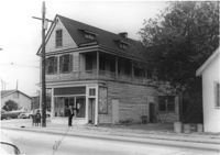
House (corner view) on site affected by the construction of Interstate 26 (I-26). Address: 1226 King Street. View of street corner; corner of King Street and Mount Pleasant Street. First story is Sanex Cleaners. Sign for Coastal Carolina Fair posted on side of building. Surveyor notations on back of photo: "Dkt.: 10.503. Property owner: Mary E. Lea Ward. Tract: 14-B. Station: 11+50 Rt. (Mt. Pleasant St.). Date: Apr. 20, 1965." [See collection description for explanation of surveyor notations.]
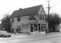
House (corner view) on site affected by the construction of Interstate 26 (I-26). Address: 1226 King Street. View of street corner; corner of King Street and Mount Pleasant Street. First story is Sanex Cleaners. Directional sign for St. John Hotel and sign for Coastal Carolina Fair posted on side of building. Surveyor notations on back of photo: "Dkt.: 10.503. Property owner: Mary E. Lea Ward. Tract: 14-B. Station: 11+50 Rt. (Mt. Pleasant St.). Date: Apr. 20, 1965." [See collection description for explanation of surveyor notations.]
House (side view) on site affected by the construction of Interstate 26 (I-26). Address: 1226 King Street. View of street corner; corner of King Street and Mount Pleasant Street. First story is Sanex Cleaners. Directional sign for St. John Hotel and sign for Coastal Carolina Fair posted on side of building. Surveyor notations on back of photo: "Dkt.: 10.503. Property owner: Mary E. Lea Ward. Tract: 14-B. Station: 11+50 Rt. (Mt. Pleasant St.). Date: Apr. 20, 1965." [See collection description for explanation of surveyor notations.]
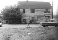
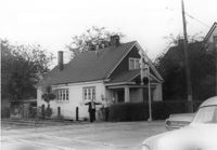
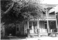
House on site by the construction of Interstate 26 (I-26). Address; 35 Mount Pleasant Street. Number 7 on porch column. At corner of railroad tracks and Mount Pleasant Street. Surveyor notations on back of photo: "Dkt.: 10.503. Property owner: Henry Fritz. Tract: 14-C. Station: 12+10 Rt. (Mt. Pleasant St.). Date: Apr. 20, 1965." [See collection description for explanation of surveyor notations.]
House on site by the construction of Interstate 26 (I-26). Address: 35 Mount Pleasant Street. Corner view from railroad tracks at Mount Pleasant Street. Surveyor notations on back of photo: "Dkt.: 10.503. Property owner: Henry Fritz. Tract: 14-C. Station: 12+10 Rt. (Mt. Pleasant St.). Date: Apr. 20, 1965." [See collection description for explanation of surveyor notations.]
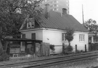
House on site by the construction of Interstate 26 (I-26). Address: 35 Mount Pleasant Street. Corner (rear) view from railroad tracks in foreground. Joseph Floyd Manor (Mount Pleasant Street and King Street) in background. Surveyor notations on back of photo: "Dkt.: 10.503. Property owner: Henry Fritz. Tract: 14-C. Station: 12+10 Rt. (Mt. Pleasant St.). Date: Apr. 20, 1965." [See collection description for explanation of surveyor notations.]
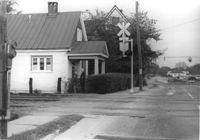
House (side view) on site by the construction of Interstate 26 (I-26). Address: 35 Mount Pleasant Street. View of house from railroad tracks at Mount Pleasant Street. View of street corner, looking down King Street. Surveyor notations on back of photo: "Dkt.: 10.503. Property owner: Henry Fritz. Tract: 14-C. Station: 12+10 Rt. (Mt. Pleasant St.). Date: Apr. 20, 1965." [See collection description for explanation of surveyor notations.]
House on site affected by the construction of Interstate 26 (I-26). Address: 78 Fishburne Street. Surveyor notations on back of photo: "Dkt.: 10.517. Property owner: Rosetta E. Richardson. Tract: 124. Station: 24+00 Lt. (Line "1" survey). Date: November 4, 1965. Subject building and entire lot entirely in R/W. Bought." [See collection description for explanation of surveyor notations.]
House on site affected by the construction of Interstate 26 (I-26). Address: 78 Fishburne Street. Surveyor notations on back of photo: "Dkt.: 10.517. Property owner: Rosetta E. Richardson. Tract: 124. Station: 24+00 Lt. (Line "1" survey). Date: November 4, 1965. Subject building and entire lot entirely in R/W. Bought." [See collection description for explanation of surveyor notations.]
Right of way--South Carolina--Charleston County, Highway planning--South Carolina--Charleston County, Vernacular architecture--South Carolina--Charleston County, Lost architecture--South Carolina--Charleston County, Dwellings--South Carolina--Charleston County✖[remove]122