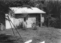
Cinder-block structure (shed?) on site affected by the construction of Interstate 26 (I-26). Surveyor notations on back of photo: "Dkt.: 10.480. Property owner: Crider O. Murray. Tract: 202. Station: 5689+80 Lt. Date: May 31, 1961. In R/W - Bought." [See collection description for explanation of surveyor notations.]
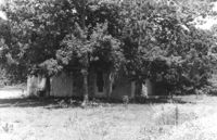
Cinderblock structure on site affected by the construction of Interstate 26 (I-26). Obscured by trees. Surveyor notations on back of photo: "Dkt.: 10.480. Property owner: Mrs. Margaret H. Patterson. Tract: 241. Station: 5702+60 Lt. Date: May 31, 1961. In R/W - Bought." [See collection description for explanation of surveyor notations.]
Cinderblock structure and doghouse, on site affected by the construction of Interstate 26 (I-26). Surveyor notations on back of photo: "Dkt.: 10.480. Property owner: D.T. Browning. Tract: 264. Station: 5714+60 Lt. Date: May 31, 1961. In R/W - Bought." [See collection description for explanation of surveyor notations.]
Right of way--South Carolina--Charleston County, Highway planning--South Carolina--Charleston County, Lost architecture--South Carolina--Charleston County✖[remove]3