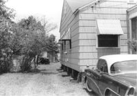
Corner of house, with view of shed at rear of property, on site affected by the construction of Interstate 26 (I-26). Possibly on Rivers Avenue. Surveyor notations on back of photo: "Dkt.: 10.486. Property owner: Mrs. Ida K. Hill. Tract: 16. Station: 12+00 Rt. (Main Line). Date: May 30, 1961. In R/W - Bought." [See collection description for explanation of surveyor notations.]
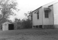
Corner view of house and garage/shed, on site affected by the construction of Interstate 26 (I-26). Surveyor notations on back of photo: "Dkt.: 10.480. Property owner: Mary E. Martin. Tract: 261. Station: 5712+75 CL. Date: May 2, 1961. In R/W - Bought." [See collection description for explanation of surveyor notations.]
Limit your search
SCDOT Photographs: Properties in the Right-of-Way✖[remove]2
Right of way--South Carolina--Charleston County, Highway planning--South Carolina--Charleston County, Vernacular architecture--South Carolina--Charleston County, Lost architecture--South Carolina--Charleston County, Dwellings--South Carolina--Charleston County, Sheds--South Carolina--Charleston County✖[remove]2