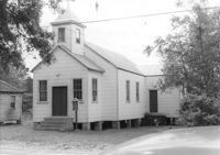
Enah Chapel Church on site affected by the construction of Interstate 26 (I-26). Surveyor notations on back of photo: "Dkt.: 10.480. Property owner: Enoch Methodist Church. Tract: 36. Station: 5507+80 Lt. Date: May 2, 1961. In R/W - Bought." [See collection description for explanation of surveyor notations.]
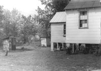
Enah Chapel (side view, rear) and structure that appears to be an outhouse, on site affected by the construction of Interstate 26 (I-26). Surveyor notations on back of photo: "Dkt.: 10.480. Property owner: Enoch Methodist Church. Tract: 36. Station: 5508+20 Lt. Date: May 2, 1961. In R/W - Bought." [See collection description for explanation of surveyor notations.]
Limit your search
SCDOT Photographs: Properties in the Right-of-Way✖[remove]2
Right of way--South Carolina--Charleston County, Highway planning--South Carolina--Charleston County, Vernacular architecture--South Carolina--Charleston County, Lost architecture--South Carolina--Charleston County, Church buildings--South Carolina--Charleston County✖[remove]2