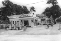
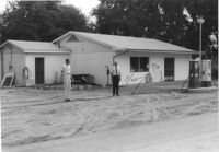
Gulf gas station, on site affected by the widening of State Road 13 (Remount Road). Surveyor notations on back of photo: "Dkt.: 10.562. Property owner: E.R. Gassman. Tract: 1. Date: Jul. 12, 1967." [See collection description for explanation of surveyor notations.]
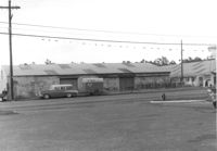
Renken Boat Co, on site affected by the widening of Route 171 (Folly Road). Surveyor notations on back of photo: "Dkt.: 10.494. Property owner: Renken Finance Co. Tract: 19. Station: 157+00 Lt. Date: Mar. 21, 1962. Proximity. [See collection description for explanation of surveyor notations.]
Description and index of Civic Services Committee materials that were taken from Carolina Art Association and incorporated into the files of what became Historic Charleston Foundation. Also includes a list of materials "now on deposit at SC Historical Society," and the finding aid to the Civic Services Committee records that are still held at the Gibbes Museum of Art.
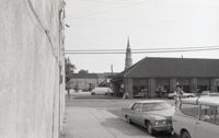
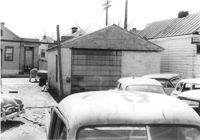
Houses (review view) on site affected by the construction of the Crosstown. Address: 80 Cooper Street. Surveyor notations on back of photo: "Dkt.: 10.518. Property owner: Helen Phillips Brown. Tract: 9. Station: 38+95 Rt. N.B. lane Route 17. Date: Mar. 6, 1963. In R/W - Bought. [See collection description for explanation of surveyor notations.]
House on site affected by the construction of Interstate 26 (I-26). Surveyor notations on back of photo: "Dkt.: 10.471. Property owner: Noble M. Drennen. Tract: 104. Station: 5379+30 Lt. Date: Aug. 23, 1960. Proximity." [See collection description for explanation of surveyor notations.]
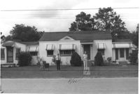
House on site affected by the construction of Interstate 26 (I-26). Building address number 22 (painted on mailbox). Surveyor notations on back of photo: "Dkt.: 10.471. Property owner: Eleanor L. O'Brien. Tract: 105. Station: 5379+50 Lt. Date: Aug. 23, 1960. Proximity." [See collection description for explanation of surveyor notations.]
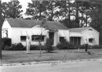
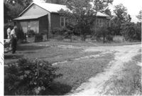
House on site affected by the construction of Interstate 26 (I-26). Surveyor notations on back of photo: "Dkt.: 10.471. Property owner: Donald C. Drennen. Tract: 106. Station: 5380+00 Lt. Date: Aug. 23, 1960. Proximity." [See collection description for explanation of surveyor notations.]
Gulf gas station on site affected by the construction of Interstate 26 (I-26). Surveyor notations on back of photo: "Dkt.: 10.471. Property owner: W.W. Holcombe. Tract: 109. Station: 5380+00 Lt. Date: Aug. 23, 1960. Proximity." [See collection description for explanation of surveyor notations.]
House on site affected by the construction of Interstate 26 (I-26). Surveyor notations on back of photo: "Dkt.: 10.471. Property owner: Annie C. Craven. Tract: 116. Station: 5396+10 Rt. Date: Aug. 23, 1960. In R/W - Bought." [See collection description for explanation of surveyor notations.]