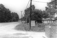
Roadside lot on site affected by the widening of U.S. Route 17. Presumably located in Mount Pleasant or vicinity. Surveyor notations on back of photo: "Dkt.: 10.439. Property owner: Louise S. Carter. Tract: 3. Station: 230±50 Rt. Date: Jul. 22, 1965. Looking NE from Carter Ave. at range poles on 33' & 50' R/Ws - Cond." [See collection description for explanation of surveyor notations.]
Roadside lot on site affected by the widening of U.S. Route 17. Presumably located in Mount Pleasant or vicinity. Surveyor notations on back of photo: "Dkt.: 10.439. Property owner: Louise S. Carter. Tract: 3. Station: 229±50 Rt. Date: Jul. 22, 1965. Looking NE at range on 33' R/W & 50' R/W - Cond." [See collection description for explanation of surveyor notations.]
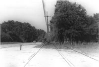
Lot on site affected by the widening of U.S. Route 17. Presumably located in Mount Pleasant or vicinity. Surveyor notations on back of photo: "Dkt.: 10.439. Property owner: Samuel D. Causey. Tract: 6. Station: 233±00 Rt. Date: Jul. 22, 1965. Range poles on 33' & 50' R/W - Cond." [See collection description for explanation of surveyor notations.]
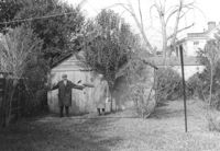
Shed and backyard on site affected by the construction of the Crosstown. Address: 112 Sheppard Street. Surveyor notations on back of photo: "Dkt.: 10.524. Property owner: Alston O. Crum, Est. Tract: 146. Station: 19+60 Lt. S.B. lane. Date: Dec. 2, 1964. Proximity." [See collection description for explanation of surveyor notations.]
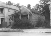
House (freedman's cottage) on site affected by the construction of the Crosstown. Address: 149 President Street. Surveyor notations on back of photo: "Dkt.: 10.524. Property owner: Mamie B. Motte. Tract: 32. Station: 67+90 Rt. Date: Oct. 13, 1964. In R/W - Bought." [See collection description for explanation of surveyor notations.]
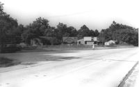
Lot and building on site affected by the widening of U.S. Route 17. Billboard for Busch Bavarian [beer] in background. Presumably located in Mount Pleasant or vicinity. Surveyor notations on back of photo: "Dkt.: 10.439. Property owner: A.J. Ashley. Tract: 19. Station: 241+92 Lt. Date: Jul. 22, 1965. Range poles on new R/W & man & range poles on pres. 33' R/W. Portion of bldg within R/W." [See collection description for explanation of surveyor notations.]
Lot and building on site affected by the widening of U.S. Route 17. Billboard for Busch Bavarian [beer] in background. Presumably located in Mount Pleasant or vicinity. Surveyor notations on back of photo: "Dkt.: 10.439. Property owner: A.J. Ashley. Tract: 19. Station: 241+92 Lt. Date: Jul. 22, 1965. Range poles on new R/W & man & range poles on pres. 33' R/W. Portion of bldg within R/W." [See collection description for explanation of surveyor notations.]
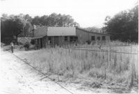
Lot and buildings on site affected by the widening of U.S. Route 17. Billboard for Busch Bavarian [beer] in background. Presumably located in Mount Pleasant or vicinity. Surveyor notations on back of photo: "Dkt.: 10.439. Property owner: A.J. Ashley. Tract: 19. Station: 238+85 to 242+45 Lt. Date: Jul. 22, 1965. Range poles on pres. & 75' R/W - Cond. 2 frame bldg." [See collection description for explanation of surveyor notations.]
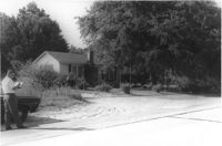
House on site affected by the widening of U.S. Route 17. Presumably located in Mount Pleasant or vicinity. Surveyor notations on back of photo: "Dkt.: 10.439. Property owner: A.J. Ashley. Tract: 20. Station: 242+85 Lt. Date: Jul. 22, 1965. Proximity." [See collection description for explanation of surveyor notations.]
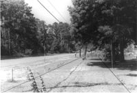
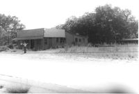
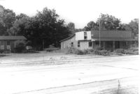
Buildings on site affected by the widening of U.S. Route 17. Presumably located in Mount Pleasant or vicinity. Surveyor notations on back of photo: "Dkt.: 10.439. Property owner: A.J. Ashley. Tract: 19. Station: 241+00 Lt. Date: Jul. 22, 1965. Range poles on pres. & 75' R/W - front of both bldg." [See collection description for explanation of surveyor notations.]