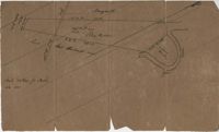
Copy of plat of 342 acres on Johns Island. Very little detail, just an outline of the property with trees on the edges. Names associated with this plat are Thomas Ladson, Hanscome, Allen, William Wallisby, Robert Murens, and Brocher. Geographic locations are the Stono River, Colleton County and Johns Island.
Plat contains 200 acres conveyed to Thomas McConnell of W town 1814. Granted to Duyal Mckechaw in 1735. Names associated with this plat are Thomas McConnell, Duyal Mckechaw, John Summerhoofs, Eliza Staufiur, and John White.
Copy of a plat of 200 acres in St. George’s Parish. The property lines and various trees located on them are the only details included. Names associated with this plat are Benjamin Cattell, Richard Bedon, and Edward North. Notable geographic locations are St. George's Parish and Cypress.
Copy of a plan annexed to a deed for 177 acres given by Ebenezer Simmons to the John's Island Society lying adjoining the church on Johns Island. Names associated with this plat are Johns Island Society, Ebenezer Simmons, James Lawson, Robert Gibbes, William Boone, John Freer, George Scott, Thomas Smith, Daniel Doyley, Joshua Ward, John Hanyon, John Moultrie, Isaac Wraught, and John Stanyarn.
A 550 acre plot of land given to Francis Middleton, the entire plot is labeled as marsh located on the banks of the branches of the Santee River. Names associated with this plat are Francis Middleton, Ephraim Mitchell, Josh Purcell and A. Darby. Notable geographic locations included are St. James Parish.
Plat of land on Goose Creek belonging to Dr. Charles Drayton. Details include an area of marsh and the location of Goose Creek. Names associated with this plat are Dr. Charles Drayton, Michau, Manigault and Richards.
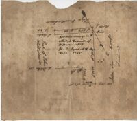
Plat consists of 100 3/4 acres. Names associated with this plat include William Walter, William Kittlebum, Coachman, Thomas Hamilton, Benjamin, Richard and Allen. Notable geographic locations include St. George Parish and Cypress.
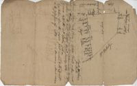
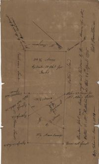
"In the above delineated plat A represents a tract of land containing 120 acres originally granted to William Sanders the 10 May 1734 for 100 acres, now held by William Allen Milis B containing 134 acres is part of a tract granted to Roger Simner the 21st day of April 1733 for 4200 acres and now held by William Edward Perry - Situated on the Cypress Swamp in St. George’s Parish Berkeley County and… a fore said and butting and bounding and having such marks and shape as are about set the Certified the 23rd July 1775 by John Fenwick Copy taken from the original in July 1801." Names associated with this plat are William Allen Milis, Roger Simner, William Edward Perry, William Benjamin Coachman, William John Glaize, Daniel Blake, William H. Drayton, Watter, Sanders, and John Fenwick. Notable geographic locations include St. George's Parish, Cypress Swamp, and Bedons.
200 acres laid out to Jonathan Stocks situated in Colleton County lying on the side of Kywa [Kiawah] Creek, shows surrounding properties with no land type or detail. Names associated with this plat are Jonathan Stock, John Jones, John Edenborough, Thomas Jones, and Thomas Weatherby.
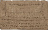
"Release from Thomas Osborn a Sheriff Charleston District to Philip Hart dated 6 October 1794 for a tract of land measuring and Containing 500 acres more or less situated lying and being on the Cypress Swamp in the district of Charleston Butting and Bounding Westwardly on land now or late the property of David Manll. Southwardly on lands of John Conard, Eastwardly on lands of Thomas Waring and Northeastwardly on lands belonging to Major James Postell - Sold under [?] in the property of William Doweth." Names associated with this plat are Thomas Osborn, William Dewitt, Hart, David Manll, John Conrad, Thomas Waring, Philip Hart, James Postell, and William Doweth. Notable geographic locations include St. George Parish, Cypress Swamp and Charleston District.
Limit your search
John McCrady Plats and Deeds Collection✖[remove]22