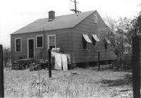
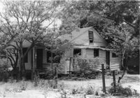
Side view of house (duplex) on site affected by the construction of Interstate 26 (I-26). Building address numbers 1809A and 1809B. Possibly on Rivers Avenue. Surveyor notations on back of photo: "Dkt.: 10.486. Property owner: Joseph S. & Vivian G. Walsh. Tract: 14. Station: 12+00 (Line D). Date: May 30, 1961. In R/W - Bought." [See collection description for explanation of surveyor notations.]
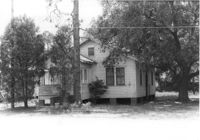
House on site affected by the construction of Interstate 26 (I-26). Building address number 1812. Possibly on Rivers Avenue. Surveyor notations on back of photo: "Dkt.: 10.486. Property owner: J.A. Livingston. Tract: 15. Station: 11+80 Lt. Date: May 30, 1961. In R/W - Bought." [See collection description for explanation of surveyor notations.]
House (rear view) on site affected by the construction of Interstate 26 (I-26). Building address number 1812. Possibly on Rivers Avenue. Surveyor notations on back of photo: "Dkt.: 10.486. Property owner: J.A. Livingston. Tract: 15. Station: 11+80 Lt. Date: May 30, 1961. In R/W - Bought." [See collection description for explanation of surveyor notations.]
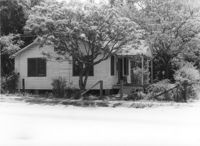
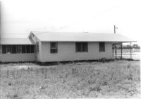
House on site affected by the construction of Interstate 26 (I-26). Possibly on Rivers Avenue. Surveyor notations on back of photo: "Dkt.: 10.486. Property owner: Mrs. Ida K. Hill. Tract: 16. Station: 12+00 Rt. (Main Line). Date: May 30, 1961. In R/W - Bought." [See collection description for explanation of surveyor notations.]
Corner of house, with view of shed at rear of property, on site affected by the construction of Interstate 26 (I-26). Possibly on Rivers Avenue. Surveyor notations on back of photo: "Dkt.: 10.486. Property owner: Mrs. Ida K. Hill. Tract: 16. Station: 12+00 Rt. (Main Line). Date: May 30, 1961. In R/W - Bought." [See collection description for explanation of surveyor notations.]
House (rear view) on site affected by the construction of Interstate 26 (I-26). Possibly on Rivers Avenue. Surveyor notations on back of photo: "Dkt.: 10.486. Property owner: Mrs. Ida K. Hill. Tract: 16. Station: 12+00 Rt. Date: May 30, 1961. In R/W - Bought." [See collection description for explanation of surveyor notations.]
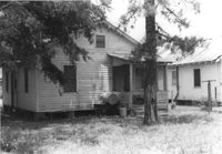
House on site affected by the construction of Interstate 26 (I-26). Possibly on Rivers Avenue. Surveyor notations on back of photo: "Dkt.: 10.486. Property owner: Edward R. Livingston. Tract: 17. Station: 12+25 Lt. Date: May 30, 1961. In R/W - Bought." [See collection description for explanation of surveyor notations.]
House (rear view) on site affected by the construction of Interstate 26 (I-26). Possibly on Rivers Avenue. Surveyor notations on back of photo: "Dkt.: 10.486. Property owner: Edward R. Livingston. Tract: 17. Station: 12+25 Lt. Date: May 30, 1961. In R/W - Bought." [See collection description for explanation of surveyor notations.]
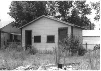
House on site affected by the construction of Interstate 26 (I-26). Possibly on Rivers Avenue. Surveyor notations on back of photo: "Dkt.: 10.486. Property owner: Alberta Sanders, Est. Tract: 19. Station: 12+80 CL. Date: May 30, 1961. In R/W - Bought." [See collection description for explanation of surveyor notations.]
House on site affected by the construction of Interstate 26 (I-26). Possibly on Rivers Avenue. Surveyor notations on back of photo: "Dkt.: 10.486. Property owner: Alberta Sanders, Est. Tract: 19. Station: 12+80 CL. Date: May 30, 1961. In R/W - Bought." [See collection description for explanation of surveyor notations.]
Letter from John Lynch in Columbia to Mother Theresa of the Sisters of Mercy in Charleston. John writes the Mother Superior about a potential conflict regarding a child boarding with the Sisters and fears the powerful influence of the child's mother could adversely affect their school. May 11, 1858. 2p.
An addendum to a longer letter, in which the writer praises Willis for keeping faith in God. The writer also states that Henry has a "lady-love" who is said to be a fine young lady, and rich.
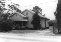
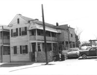
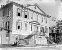
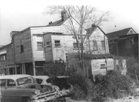
House on site affected by the construction of the Crosstown. Address: 85 Lee Street. Surveyor notations on back of photo: "Dkt.: 10.518. Property owner: Joe S. Brown, et al. Tract: 2. Station: 38+90 Lt. S.B. lane Route 17. Date: Mar. 6, 1963. In R/W - Bought. [See collection description for explanation of surveyor notations.]
William H. W. Barnwell, from Laurel Bay Plantation, writes to friend Edgar Day in Catskill, New York. After 4 years without correspondence, Barnwell apprises Day of his marriage, the birth of his first child and his religious conversion during a revival in Gillisonville, SC. He also speaks of forming a local temperance society and hopes to establish "one upon my plantation among my Negroes." January 18, 1832.
Building on site affected by the construction of Interstate 26 (I-26). May have been a barber shop (striped pole posted by door). Building address number 1818. Langston Motors in background. Possibly on Rivers Avenue. Surveyor notations on back of photo: "Dkt.: 10.486. Property owner: Dora Peagler. Tract: 20. Station: 13+50 Rt. Date: May 30, 1961. In R/W - Bought." [See collection description for explanation of surveyor notations.]
Building (rear view) on site affected by the construction of Interstate 26 (I-26). Building address number 1818. Possibly on Rivers Avenue. Surveyor notations on back of photo: "Dkt.: 10.486. Property owner: Dora Peagler. Tract: 20. Station: 13+50 Rt. Date: May 30, 1961. In R/W - Bought." [See collection description for explanation of surveyor notations.]
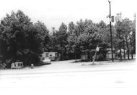
Trailers on lot on site affected by the construction of Interstate 26 (I-26). Sign "Trailers for Rent" posted on street. Possibly on Rivers Avenue. Surveyor notations on back of photo: "Dkt.: 10.486. Property owner: Raymond Peagler. Tract: 21. Station: 13+75 Rt. & Lt. (Line C). Date: May 30, 1961. Damage as appraised." [See collection description for explanation of surveyor notations.]
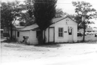
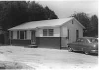
House/office on site affected by the construction of Interstate 26 (I-26). Signs "Open for Inspection" and posted office hours on front. Possibly on Rivers Avenue. Surveyor notations on back of photo: "Dkt.: 10.486. Property owner: Otis R. Burbage. Tract: 22 & 34. Station: 14+80 Rt. Date: May 30, 1961. In R/W to be moved." [See collection description for explanation of surveyor notations.]
Structure (storage shed/garage) on site affected by the construction of Interstate 26 (I-26). Possibly on Rivers Avenue. Surveyor notations on back of photo: "Dkt.: 10.486. Property owner: Otis R. Burbage. Tract: 22 & 34. Station: 14+80 Rt. Date: May 30, 1961. In R/W to be moved." [See collection description for explanation of surveyor notations.]
House/office (side view) on site affected by the construction of Interstate 26 (I-26). Signs "Open for Inspection" and posted office hours on front. Possibly on Rivers Avenue. Surveyor notations on back of photo: "Dkt.: 10.486. Property owner: Otis R. Burbage. Tract: 22 & 34. Station: 14+80 Rt. Date: May 30, 1961. In R/W to be moved." [See collection description for explanation of surveyor notations.]
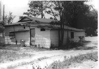
House on site affected by the construction of Interstate 26 (I-26). Building address number 4800. Possibly on Rivers Avenue. Surveyor notations on back of photo: "Dkt.: 10.486. Property owner: Redding F. Moore. Tract: 23, 24, 25. Station: 15+70 Lt. (Line C). Date: May 30, 1961. In R/W to be moved." [See collection description for explanation of surveyor notations.]
Wood-sided building on site affected by the construction of Interstate 26 (I-26). Building address number 4804. Neon sign for a Drive In (__MANER'S) (name partly illegible) in front. Billboard for First National Homes (4800 Rivers Ave.) next to building. Possibly on Rivers Avenue. Surveyor notations on back of photo: "Dkt.: 10.486. Property owner: Redding F. Moore. Tract: 23, 24, 25. Station: 15+50 Rt. (Line C). Date: May 30, 1961. In R/W - Bought." [See collection description for explanation of surveyor notations.]
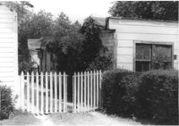
Portion of wood-sided building on site affected by the construction of Interstate 26 (I-26). Building address number 4804. Driveway gate in foreground. Possibly on Rivers Avenue. Surveyor notations on back of photo: "Dkt.: 10.486. Property owner: Redding F. Moore. Tract: 23, 24, 25. Station: 15+50 Rt. (Line C). Date: May 30, 1961. In R/W - Bought." [See collection description for explanation of surveyor notations.]
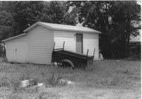
Outbuilding on site affected by the construction of Interstate 26 (I-26). Possibly on Rivers Avenue. Surveyor notations on back of photo: "Dkt.: 10.486. Property owner: Redding F. Moore. Tract: 23, 24, 25. Station: 15+90 Rt. (Line C). Date: May 30, 1961. In R/W - Bought." [See collection description for explanation of surveyor notations.]
In a letter from Columbia, John Lynch writes to his brother, Bishop Patrick Lynch in Charleston, for help in securing employment for their brother Bernard at the S.C. Statehouse. May 18, 1858. 4p.
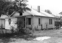
Houses (rear view) on site affected by the construction of the Crosstown. Address: 85 Lee Street. Surveyor notations on back of photo: "Dkt.: 10.518. Property owner: Joe S. Brown, et al. Tract: 2. Station: 38+90 Lt. S.B. lane Route 17. Date: Mar. 6, 1963. In R/W - Bought. [See collection description for explanation of surveyor notations.]
In a letter to his mother from London, William Manigault Heyward inquires about other family members including his brothers "Nat", Joseph, Arthur and Charles and sisters Ann and Elizabeth. He comments vividly about the social scene in London and admits after seven months he has wearied of it, having "been to so many balls, events, concerts, dinner parties, plays, operas, masquerades, etc." He mentions socializing in London with several prominent Charleston families including Pinckney, Middleton, Izard and Rutledge. He also describes firsthand the events surrounding the arrest of radical MP Francis Burdett, who was famously imprisoned in the Tower of London for libelling the House of Commons, even participating in the protests outside Burdett's house "to satisfy my curiosity and see what a London mob is." 8p.