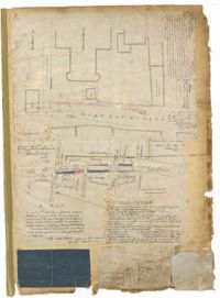
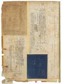
Page 1 of the City Engineer's Plat Book with four plats. Plat 1 shows the intersection of East Bay Street and Market Street, and labels reading "New Custom Ho.," "Old Flash," "Scale House," and "Market." Plat 2 shows a stretch of East Bay Street from the intersection with Guignard Street to Pritchard Street, including the bridge crossing over Canal Street. Plat 3 shows the intersection of Tradd Street and Greenhill Street. Plat 4 features Beaufain Street's intersections with St. Phillip Street and Archdale Street, and features a plot of land labelled "Normal School Yard."
Letter to Edgar M. Lazarus from Henry S. Samuel discussing the political situation in the United States following the Civil War, family, and matters at the Liverpool synagogue.
Page 120 of the City Engineer's Plat Book with five plats, labelled two through six. Plat 2 shows lots and buildings located near Cumberland Street, between Church Street and Philadelphia Street. Plat 3 shows lots located near the intersection Pinckney Street and Anson Street. Plat 4 shows lots and structures located on Hasell Street. Plat 5 shows lots and buildings along East Bay Street. Plat 6 shows lots and structures located between wharf street and the Cooper River.
Page 13 of the City Engineer's Plat Book with five plats. Plat 1 features plots on East Bay Street between Tradd Street and Broad Street (which is labelled in the top-left corner), including several wharfs. Plat 2 shows lots located between Archdale Street and King Street, including a plot belonging to the "German Lutheran Church." Plat 3 features a plot of land located on King Street. Plat 4 shows plots located on State Street between Market Street and Amen Street. Plat 5 features "Potters Field Public Cemetery," located near President Street and Congress Street.
Page 28 of the City Engineer's Plat Book with three plats. Plat 1 shows lots located near Calhoun Street, Bull Street, South Street, Ashley Street, Rutledge Street Lynch Street, and Bennett Street. Plat 1 also shows lots labelled "The Mall," and Lots Belonging to Sundry Persons. Plat 2 shows lots and buildings located near the intersection of Calhoun Street and Lucas Street, including lots labelled "Mansion Lot" and "Left for a Public Square." Plat 3 shows lots and buildings located near Bee Street, between Ashley Street and Rutledge Street.
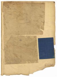
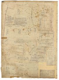
Page 2 of the City Engineer's Plat Book with five plats. Plat 1 shows the intersections of Guignard Street with East Bay Street and "Raper's Alley," and features a building labelled "Old Mansion Ruins." Plat 2 shows the intersection of East Bay Street and Market Street near the "Charleston Harbour on the Cooper River," and features plans to expand Market Street. Plat 3 features a stretch of land from the end of Rose Alley to the Cooper River, labelled as "Union Warf No. 1." Plat 4 features the same stretch of land as Plat 2 with slightly more land to the north. Plat 5 features the intersections of Tradd Street with Legare Street and Friend Street.
Page 5 of the City Engineer's Plat Book with three plats. Plat 1 shows plots near Meeting Street, Russell Street, King Street, and a creek labelled "Small Creek." Plat 2 shows plots of land near the intersection of Water Street and Church Street. Plat 3 shows Calhoun Street where it intersects with Ashley Street and Lynch Street, and shows a lot labeled "St. Xavier's Infirmary."
Page 53 of the City Engineer's Plat Book with five plats. Plat 1 shows shoals and marshlands located near the Ashley River Channel, Gibbes Street, and South Bay Street. Plat 2 features a lot and its buildings at the intersection of Broad Street and New Street. Plat 3 shows a lots and buildings located on Tradd Street. Plat 4 features lots and buildings located near the intersection of Broad Street and Tradd Street, including some stretches of marshland. Plat 5 shows lots located near Broad Street's and Tradd Street's intersections with New Street and Legare Street.
Page 62 of the City Engineer's Plat Book with eight plats. Plat 1 shows lots located near East Bay Street. Plat 2 shows a lot on Concord Street, including a wharf. Plat 3 shows three Wharf Lots on Wharf Street, near the intersection with Inspection Street. Plat 4 features a lot on Wharf Street with a dock and a brick building, across the street from a building labelled "Eagle Foundry." Plat 5 shows a lot with several buildings on East Bay Street. Plat 6 shows land near the intersection of East Bay Street and Cumberland Street, with a stretch labelled "Passage to what is now called Central Wharves." Plat 7 shows a wharf and yard on Concord Street, and a structure labelled "Cotton Shed on Brick Pillars." Plat 8 shows a lot located at the intersection of Anson Street and Calhoun Street.