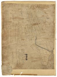
Page 104 of the City Engineer's Plat Book with one plat. The plat shows lots located between Moultrie Street and Cunnington Street. It also shows Lemon Street, Lee Street, Price Street, and Magnolia Street. It also shows a plat labelled "Artilery Society" and another plat labelled "Magnolia Cemetery."
Page 141 of the City Engineer's Plat Book with four plats. Plat 1 features a lot and structures located between Lynch Steet and the Ashley River, near Broad Street. It also shows Comings Creek, a pond, and a lot labelled "Clark & Steinmeyer." Plat 2 shows lots and structures located near the intersection of College Street and Calhoun Street. Plat 3 shows a lot and structures in "the City of Charleston in Ward No. 9." Plat 4 shows lots on and near Society Street, between Meeting Street and King Street.
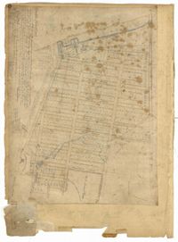
Page 220 of the City Engineer's Plat Book with one plat. The plat shows lots extending from the Ashley River, past Lucas Street. The plat also shows Doughty Street, Calhoun Street, President Street, U. S. Arsenal Square, and several structures.
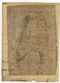
Page 80 of the City Engineer's Plat Book with one plat. The plat shows a plan for developing a stretch of land from the Ashley River towards President Street and Lucas Street, with a few lots and structures further east. The plat also shows a lot labelled "U. S. Arsenal Square," and a mill on the Ashley River.
Page 3 of the City Engineer's Plat Book with four plats. Plat 1 features lots at the intersection of Laurens Street and East Bay Street, and labels a section of salt marsh. Plat 2 shows plots at the intersection of East Bay Street and Hasell Street. Plat 3 features three lots of land and buildings on East Bay Street. Plat 4 shows a stretch of Pinckney Street between Bay Street and the Cooper River, including several lots.
Page 79 of the City Engineer's Plat Book with six plats. Plat 1 shows a lots and some structures located between Doughty Street and Palmetto Street, and also shows Ashley Street and a structure labelled "United States Arsenal Wall." Plat 2 shows lots located near the intersection of Bee Street and President Street. Plat 3 shows lots located on Doughty Street, between Ashley Street and Rutledge Street. Plat 4 features lots and land located near the intersection of Bee Street and President Street. The plat also shows a mill pond and several structures. Plat 5 shows lots located between Doughty Street and Mill Street, and near Ashley Street. Plat 5 also shows Palmetto Street and a lot labelled U. S. Arsenal. Plat 6 shows lots located between Thomas Street and Pinckney Street, with several structures.
Page 6 of the City Engineer's Plat Book with three plats. Plat 1 shows a lot on the Ashley River. Plat 2 shows lots on Friend Street located between Broad Street and Tradd Street. Plat 3 features lots on King Street and includes a lot labeled "Orphan House Lot."
Page 20 of the City Engineer's Plat Book with two plats. Plat 1 shows lots and buildings located near the Cooper River, Warf Street, and Concord Street, including a rice mill and a lot labelled "Atlantic Steam Packet Company." Plat 2 shows a city block between State Street and East Bay Street, and Market Street and Cumberland Street.
Page 18 of the City Engineer's Plat Book with two plats. Plat 1 shows lots located near King Street, Moultrieville Street, and Huger Street. Plat 2 shows lots located near the Cooper River, Charlotte Street, and Washington Street.