82 Acre plat of land, shows some trees with minimal notation. Names associated with this plat are John Green and Anthony Mitchell. Notable geographic locations include Waccamaw Neck.
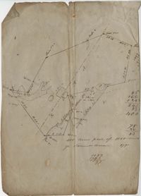
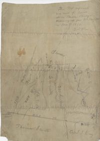
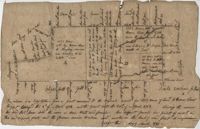
Plat of 130 acres on the Pee Dee River. Explains the plat and the surrounding area, drawing itself has little detail. Names associated with this plat are William Swinton, Joseph LaBruce, John White, James St. John, Elias Hopkin, and Thomas [?]. Notable geographic locations include the Pee Dee River, Black River, Weehaw Plantation, Kensington Plantation, Weehaw Creek, Georgetown, and Craven County [now in parts of Berkeley, Charleston, Georgetown, and Williamsburg counties].
Plat of 383 acres on Mary Creek Swamp belonging to Joseph Coachman. Details include the property lines, the location of the swamp, and location of a few trees. Names associated with this plat are Joseph Coachman, J. Hardwick, John LaBruce, Cattle, and Ralph Izard.
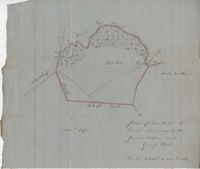
400 acre plot of David Elliot that includes what appears to be a marsh called Great Bay, no land types or detail. Names associated with this plat are David Elliot, Washington, Henry Sattus and J. Hardwick. Notable geographic locations include Georgetown and Great Bay.
Plat of 200 acres above Bacon Bridge surveyed for William Drayton. Details include the property lines, trees, the location of the swamp, a field, a canal and roads. Names associated with this plat are Joseph Coachman, William Drayton, Thomas, Thomas Smith, J.J. Keersy [?], Chandless, Gales, and J.H. Waring. Notable geographic locations include Mary Creek Swamp [?], Broad Road, and Bacon Bridge.
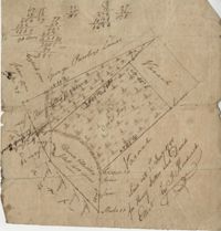
Copy of a plat laid out at Goose Creek now belonging to Benjamin Mazyck. 200 acres of land commonly called Busharia. Butting and bounding on the north and west on Col. James Moore land and the south on Captain Schrenckingh and on the east on Madam Davis' land. Names associated with this plat are Benjamin Mazyck, Davis, Lawson, Thomas Smith, Benjamin Schrenckingh, James Moore, and David Daw. Notable geographic locations include Busharia, Booshee, and Goose Creek.
Plan of lands at Bee Creek belonging to Mr. James Bolen called Gray's Hill. Names associated with this plat include James Bolen. Notable geographic locations include St. Lukes Parish, Gray's Hill, Grey's Hill Landing, Bees Creek, and Purrysburgh.
Copy of a plat annexed to the original grant for 1153 acres of land to Thomas Farr lettered A-E. Names associated with this plat are Daniel Green, Thomas Farr, Elizabeth Gibbs, Christopher Wilkinson, Joseph Smith, Andrew Smith, Thomas Smith, George Haig, Joseph Farr, Humphrey Sommers, and Benjamin Stoney.
Plat of 320 acres in the Georgetown District on the Black Mingo waters with marshes surrounding it. Little detail included. Names associated with this plat include Thomas Bull, Job Rothmaler, McCottry, Robert Davidson, Hugh Swinton and Sam Day.