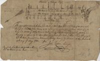
FRONT: Plat is on the northside of the Ashley River. Contains 200 acres. BACK: Plat contains 36 acres on the North side of the Ashley River. Names associated with this plat are Richard Baker, Elibee Baker, John Baker, Josiah Baker, John Guptan, James Cantley [?], James Glen, John Stevens, Joseph Child, John Ainslee, Richard Baker, William Cattell and George Hunter. Notable geographic locations include St. George's Parish, Ashley River and Berkeley County.
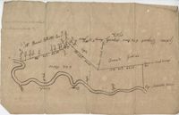
Plat includes 624 acres surveyed for Gideon DuPont. Plat does not contain structures. Names associated with this plat are Gideon DuPont, William Thomas Elliot, Captain Daniel Godin, and Middleton. Notable geographic locations are St. Bartholomew's Parish, the Ashepoo River and Deer Creek.
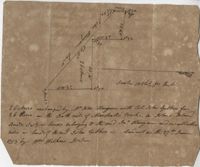
26 acres of land exchanged by John Stanyarn with Col. John Gibbes in the north side of Marshall's Creek on John's Island. Bounding on the south on lands belonging to the said Stanyarn and on all other sides on lands of John Gibbes. Laid out in 1753. Names associated with this plat are John Stanyarn, John Gibbes and Wilkins. Notable geographic locations include Johns Island and Marshall's Creek.
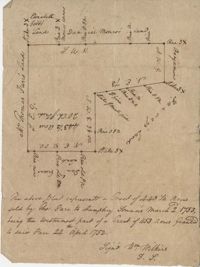
Plat of a tract of land with 443.5 acres sold by Thomas Farr to Humphrey Sommers. It is the westernmost part of a tract of 1153 acres granted to said Farr in 1752. Names associated with this plat include Thomas Farr, Humphrey Sommers, Wilkins, Elizabeth Gibbs, Daniel Monro, Benjamin Harvey and Daniel Green.