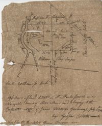
196 acres of land located in St Pauls Parish on a navigable branch of Stono River amd belonging to the confiscated estate of James D. Yarborough. Names associated with this plat include Thomas Ferguson, James Yarborough, G. Trotti, William Williamson, Charles Elliot, William Clay Snipes, Thomas Broughton, Edmond Bellinger, and Thomas Cliffon. Notable geographic locations include St. Paul's Parish, the Stono River, Road to Willows, Rutledge’s Creek, Road to Pon Pon and Jacksonborough.
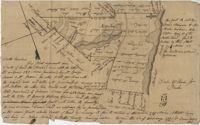
120 acre plot purchased by George Rivers, shows Bohicket Creek and several smaller creeks, also denotes some marsh, highland, and riverbanks, the plot of land is divided into six smaller plots with "Broad Road" running between them. Names associated with this plat are John Rivers, Dr. Micah Jenkins, James Stanyon, George Rivers, Hearn, Matthews, Solomon Freer, William Spencer, James Rivers, John Taylor, Margaret Simpson, William Holmes, John Holmes and James Legare. Notable geographic locations are Bohicket Creek, Johns Island, and Colleton County.
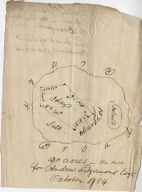
Plan of a tract of land containing 130 acres situated in Darres [Parris] Island in Beaufort. Names associated with this plat are Andrew Fitzsimons. Notable geographic locations include Beaufort, Darres [Parris] Island, and Broad River.