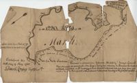
BACK: John Griggs 1220 acres Charleston 1 June 1786 [?] Peter Freneau. FRONT: “Pursuant to a warrant from Ephraim Mitchell Esquire Surveyor General and laid out unto John Griggs a Tract of land containing one thousand two hundred and twenty acres (1220) situated in St. Bartholomew's Parish Charleston District and has such shape form and marks as the above plat represents. Likewise butting and bounding as the said plat specifies." Names associated with this plat are John Griggs, Ephraim Mitchell, Daniel Doyley, Edmund Belling, Gochran, Gabriel Stock, Gochnan [?], and Peter Freneau [?]. Notable geographic locations include the Ch[?]aw River, Charleston District and St. Bartholomew's Parish.
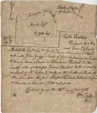
“Pursuant to a War- Mitchell Esquire Surveyor General [having been] admeasured and laid out unto John Griggs a tract of land containing one hundred and ninety (190) acres situated in Charleston District on the South side of Ashepoo River Bounded South-Westwardly on Lands of [?] Ladson, and part on Mr. Smiths lands on all other sides upon the said Ashepoo River and hath such form and marks as the above plat represents. Certified...this 26 day of June 1786 William Tate D. S." Names associated with this plat are John Griggs, William Tate, Ladson, Smith, Peter Freneau, and Ephraim Mitchell.
83 acre parcel of land that shows the land belonging to the estate of William Williamson, shows rice fields, swamp in woods, public drains, and roads. Names associated with this plat are William Williamson, George Haigery, and James Parsons. Notable geographic locations include the Stono River and Wenners.
"Copy of a plat of a tract now belonging to Richard Goughlr." The tract contains 500 acres and states that it was granted to Isaac Lewis on March 21, 1715. Names associated with this plat are Isaac Lewis, John Broughton, John Glover, John Diamond, and Richard Goughlr [?]. Notable geographic locations include Goose Creek, St. James Parish and Black Jon Bay.
Tract of land includes 224 acres. Plat includes house and cemetery as well as a path and road. Names associated with this plat are William Harvey, William Charles, Thomas Elliott, William Harvey, Charles Linning, and Charles Elliott. Notable geographic locations include St. Andrews Parish and Wappoo Creek.
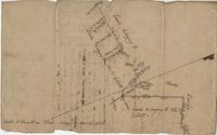
876 acres of land west of Murray Road in St. John's Parish. Names associated with this plat are Chas Johnston, Ben Castell, William Simpson, Verth, and J.G. Wiare. Notable geographic locations include Wadboo Barony.
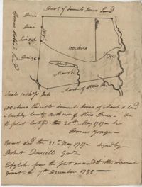
Plat of approximately 300 acres of marsh and farm land on the Stono River. Marsh and high land are denoted on the plat with few other details. Names associated with this plat are Mansfield, Mathuvin [?] Guevin, Franics [?] Guevin, Rebecca Chapman, Francis Wilkinson, Gaspar Trotti, and Stephen Ravenel. Notable geographic locations are the Stono River.
Copy of a plat granted to Abraham Michau north side of Santee and containing 213 acres in the Georgetown district in Craven County [now in parts of Berkeley, Charleston, Georgetown, and Williamsburg counties]. Names associated with this plat are Abraham Michau, James St. John, Thomas Broughton, Paul Michau, and John Dear.
Plat of 210 acres belonging to William Williams surrounded by land owned by Thomas Pinckney, Christopher Smith, and Thomas Dalton. No other notes written as to the location of the land. Very little detail on the plat included. Names associated with this plat include William Williams, Thomas Pinckney, Christopher Smith, Thomas Daulton, Thomas Smith, Edward Weekly, William Dry, Ralph Izard, Charles Fields, John Jolhimns [?], Thomas Broughton, and Hannah English aka Hannah Williams.
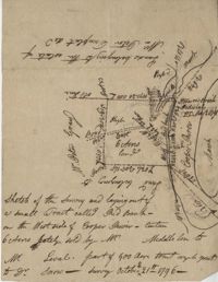
77 acres of marsh in two pieces situated on Johns Island along Stono River. Names associated with this plat are J.N. Mainville, Thomas Simmons, James Nicholas, Guervin, William Simmons and Marshall. Notable geographic locations are the Stono River, Johns Island, Charleston District, and Marshalls Creek.
Limit your search
John McCrady Plats and Deeds Collection✖[remove]102