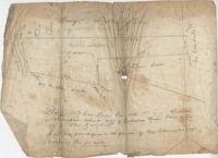
Copy of Plat of 157 acres of land laid out to Harrison on Wadmalaw Island at the head of Wadmalaw River. Names associated with this plat are Christopher Harrison, Henry Walkins, and Luna Williams.
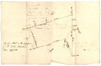
Tract of land on Pawley's Island containing 10 acres situated to the south west of Hasell, known as Lot No.6. Names associated with this plat are Colonel P. Fraser, Hasell, Goudin, Robert Campbell, Anderson, Hoben [?], Joseph Port-Geaur, Thomas Bouhia [?], May Smith, H. Eclert [?], D. Wary, W. Snipes, Mazyck, Mitchell and Grant. Notable geographic locations include Pawley's Island, Georgetown District and Sash Creek.
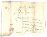
Copy of a plat of annexed to the original grant to John Stanyarn for 300 acres on Wadmalaw Island now belonging to Barnet Adams. Names associated with this plat include Barnet Adams, Edmund Bellinger, John Stanyarn, William Green, Joseph Tobias, Christopher Williamson, John Mill and Winborne Laughton. Notable geographic locations include Wadmalaw Island and Bohicket Creek.
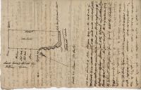
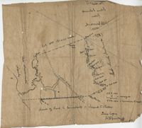
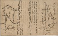
Copy of a plat of 355 Acres of land in Berkeley County near the West side of Cooper River, shows surrounding properties, doesn’t include land type or detailed notations. Names associated with this plat are Edward Keating, William Kimlough, Buvet, Matthew Beard, Colonel Chicken, Chapennoun Elliott, Robert Daniell, Longrove Thomas, Edward Keyting, Andrew Allens, William Gibbons, James Kenloch, William Adams, Allen Anderson, William Gibbons, Matthew Benson, Thomas Smith, John Vecandge [?], Francis Ternandol, and Allen Andrew. Notable geographic locations include St. James Parish, Goose Creek, Cooper River, and Berkeley County.
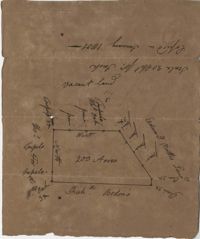
Copy of a plat of 200 acres in St. George’s Parish. The property lines and various trees located on them are the only details included. Names associated with this plat are G. Wagner, Samuel Jones, Thomas Hotkins, Francis Yonge, and Robert Daniell. Notable geographic locations include the Stono River and Berkeley County.
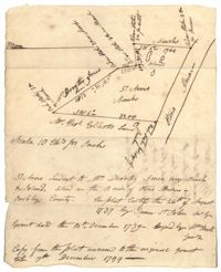
Plat of 57 acres belonging to Dorothy Jones on the Stono River. At the time of the copy belonged to George Wagner. Names associated with this plat are Dorothy Jones, George Wagner, Bull and John St. James.
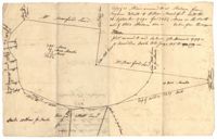
Plat of land annexed to a release from Benjamin Elliott to William Brandford for 362.5 acres. At the time of the copy belonged to George Wagner. Names associated with this plat include William Branford, Benjamin Elliott, Wagner George and Thomas Elliott.
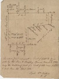
Plat of a tract of land with 443.5 acres sold by Thomas Farr to Humphrey Sommers. It is the westernmost part of a tract of 1153 acres granted to said Farr in 1752. Names associated with this plat include Thomas Farr, Humphrey Sommers, Wilkins, Elizabeth Gibbs, Daniel Monro, Benjamin Harvey and Daniel Green.
Copy of two plats: 1) 300 acres conveyed by Thomas Lynch to William Moultrie April 1, 1762, afterwards conveyed by Moultrie to Benjamin Singleton 2) 53 acres conveyed by Francis Kinloch to William Moultrie on the 8th February, 1765 now belonging to Benjamin Singleton. Names associated with this plat are Thomas Lynch, William Moultrie, Benjamin Singleton, Francis Kinloch, and Manigault. Notable geographic locations include Santee, White Oak, Six Mile Creek, and the Santee River.
Limit your search
John McCrady Plats and Deeds Collection✖[remove]102