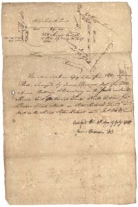
250 acre plot given to Peter Lesesne on the 20th of February 1760, butting and bounding on the south side of the Santee River. Names associated with this plat are Peter Lesesne, James Thomson, Peter Robert, Joseph Manap [?], and Phippes.
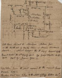
True copy of Peter Sinkler plat contains 310 acres in Craven County [now in parts of Berkeley, Charleston, Georgetown, and Williamsburg counties] bounding northwest on land of Isaac Porcher and Rene Pyre, southeast on land of Robert Taylor and Rene Ravenel, and northwest on Santee River. Names associated with this plat are Peter Sinkler, Robert Taylor, Ephraim Mitchell, Rene Pyre, Isaac Porcher, Rene Ravenel, John Brernon, and Henry Mowlon. Notable geographic locations include St. James Parish, the Santee River and Craven County.
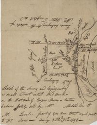
Plan of the land claimed by James Sinkler on Santee River and comprehended with the claim of White Oak Plantation belonging to Ralph Izard. Names associated with this plat are Ralph Izard, James Sinkler, Peter Sinkler, John Guerry, and Stephens.
Copy of a plat granted to Abraham Michau north side of Santee and containing 213 acres in the Georgetown district in Craven County [now in parts of Berkeley, Charleston, Georgetown, and Williamsburg counties]. Names associated with this plat are Abraham Michau, James St. John, Thomas Broughton, Paul Michau, and John Dear.
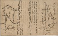
Copy of two plats: 1) 300 acres conveyed by Thomas Lynch to William Moultrie April 1, 1762, afterwards conveyed by Moultrie to Benjamin Singleton 2) 53 acres conveyed by Francis Kinloch to William Moultrie on the 8th February, 1765 now belonging to Benjamin Singleton. Names associated with this plat are Thomas Lynch, William Moultrie, Benjamin Singleton, Francis Kinloch, and Manigault. Notable geographic locations include Santee, White Oak, Six Mile Creek, and the Santee River.