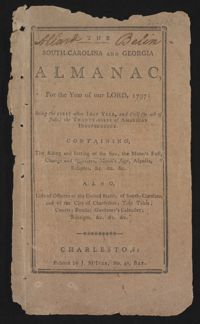
This is a Sandy Island plantation journal written inside of The South Carolina and Georgia Almanac for the year 1792. The plantation journal documents the planting of crops (rice, corns, and potatoes), the maintenance of ditches and drains, slave records, complications with the hiring of an overseer, livestock, and business relations with Laurel Hill Plantation.
One of three scrapbooks compiled by William Henry Johnson containing, among other materials, photographs depicting scenes of the South Carolina Lowcountry, with descriptive notes. Volume 1 includes photographs depicting cemeteries, churches, plantations, historic buildings, ruins, landscapes, and the interiors of buildings. Subjects include locations in Berkeley County, St. Johns (Berkeley) Parish, Goose Creek, and along the Cooper River. Other sites and subjects include Belmont, Black Oak Church, Bluford, Casada, Cedar Grove, Cedar Spring, Comingtee, a Prioleau family burial ground, Crowfield, Dean Hall Plantation, Dockon Plantation, Eutaw, Eutaw Springs, Exeter, Fairspring, Fort Dorchester, Four Hole Swamp, Gippy, Gravel Hill, the gravestone of Susan Bee, Hanover Plantation, Indian Fields Campground, Ingleside, Indianfield, Liberty Hall Club, Lewisfield, Magnolia Cemetery, monument of Col. Hezekiah Maham, grave of Major Majoribanks, Medway Plantation, Mepkin, a milestone by the Cooper River, Moorfield, Mount Pleasant Plantation, Mulberry Castle, North Hampton, Numertia, The Oaks Plantation, Ophir, Otranto Hunting Club, Parnassus, Pimlico, Pinegrove, Pond Bluff, Pooshee Plantation, John Poppenheim's plantation, Quarter house, Red Bank Hunting Club, an Episcopal church in Pineville, Rice Hope Plantation, The Rocks, St. James Goose Creek church, St. Johns Berkeley rectory site, St. Johns AME Church, a St. Julien family house, a Santee Canal lock, "Sarrazin house," a shanty, Somerset Plantation, Somerton Plantation, "Francis Marion spring," Springfield, Stoney Landing, Strawberry Chapel, Ten Mile Hill, Thoroughgood, Wadboo Barony, Wadboo bridge, Walnut Grove, Walworth, Wampee, Wampoolah, Wappetaw, Washington Plantation, the Whaley place, White Hall, Wiskinboo, Woodlawn, and Yeamans Hall.
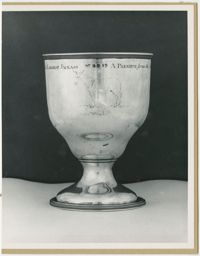
A black and white mounted photograph of one of three sides of a sliver chalice awarded as 'A premium from the Agricultural Society of So. [South] Carolina, to General [George] Washington for raising the largest jackass.' This side has an engraving of a donkey and the beginning and ending sentiments of the chalice.
Receipt book kept by Eliza L. Pinckney includes formulas for making medicines to treat croup, fever, dropsy, and other conditions; recipes for cheese cake, puddings, currant wine, orange marmalade, jelly, oyster soup, and other foods; instructions for preparing meats and rice, and preserving and pickling foods; and a formula "To make the hair grow."
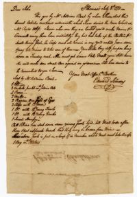
A letter from Edward Simons in St. Thomas to John Ball in Charleston, South Carolina discussing a shipment of articles sent to John by Mr. Addison's boat and requesting that the enslaved persons Minus and Cromwell carry the articles upon arrival.
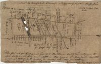
876 acres of land west of Murray Road in St. John's Parish. Names associated with this plat are Chas Johnston, Ben Castell, William Simpson, Verth, and J.G. Wiare. Notable geographic locations include Wadboo Barony.
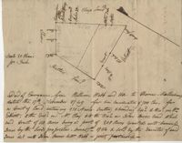
Plat of land of 64 acres laid out for Allard Belin situated on Sandy Island. Names associated with this plat are Allard Berlin, John Hardwick and D.T. Waring.
Copy of plan of a plantation on Stono Swamp commonly called Stono Plantation belonging to Thomas Ferguson. Contains 630 acres. Approximately 360 acres is swamp and approximately 270 acres is highland. Names associated with this plat are Thomas Ferguson, George Haig, Joseph Farr, Mary Williams, Smith and John McSweeney. Notable geographic locations include Stono Swamp, Stono Plantation and Charleston.
This is a Sandy Island plantation journal written inside of the South Carolina and Georgia Almanac for the year 1797. The plantation journal documents the planting of crops (rice, corn and potatoes), slave records (including runaway slaves), accounts, the weather, and business relations with Laurel Hill Plantation.
Copy of tract of land containing 200 acres, butting and bounding south and west by William Elliott, and on the east by Clay, and to the north by John Rivers. Names associated with this plat include William Webb, Thomas Mellichamp, Butler, William Elliott, William Clay, Shem, John Rivers, John S. Cripps, Samuel Jones, the Lords Proprietors, and Daniel Gibson.