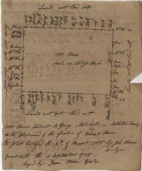
Plat of 500 acres belonging to George Mitchell in Colleton County near the Edisto River. Includes the outline of the property and the location of trees on the property line. Names associated with this plat are George Mitchell, Job Howe, and James Moore. Notable geographic locations include the Edisto River, Colleton County and St. Bartholomew's Parish.
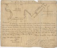
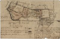
500 Acre plantation, on the northeast side of the south Edisto River, neighbors the 416/2-13 plat, the 416/2-13 is added in pencil over the writing at the bottom of the plat, no land type or detail. Names associated with this plat are John Gerardeau, Charles Craven, William Livingston, Thomas Broughton, and Charles Parker. Notable geographic locations include South Edisto River and Colleton County.
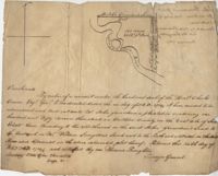
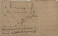
150 acre plot budding and bounding on the east side of the Edisto River, shows south Edisto River and surrounding plot owners, no land detail. Names associated with this plat are John Gerardeau, William Livingston, Charles Gruren, and Thomas Broughton. Notable geographic locations include South Edisto River and Colleton County.
Plan of a tract of land on the NE side of Edisto River called Riverside Plantation and contains 1100 acres belonging to estate of Thomas Ferguson lately sold to Martin. Names associated with this plat included Benjamin Berry, Bull, Martin, John Eberley, Edward Perry, and Thomas Ferguson. Notable geographic locations include St. Paul's Parish, the Edisto River, Parkers Ferry, Public Road to Charleston, Riverside Plantation, and Charleston District.
"A Plan of a Plantation or Tract of Land on Penny Creek a Branch of Ponpon or Edisto River late the property of Joseph Bee Esquire now belonging to John Champney Esquire." Plat contains 687 acres on the north side of Penny Creek the plat is divided by use of lands and the location of structures on the property. Names associated with this plat are John Champney, Dr. John Mitchell, Thomas Bee, Joseph Bee, and George Savage. Notable geographic locations include Penny Creek, Edisto River, Pon Pon River, Landing Road, and Bridge Road.
Plat of Hopewell Plantation with surrounding lands owned by several people, shows the Edisto River and an unnamed settlement, labels the land in the center as uncleared land while swamps, roads, rivers and trees surround it. Acreage unclear. Names associated with this plat are Baring, Branford, Mellechamp, Colonel W. Hayne and Arthur Middleton. Notable geographic locations are St. Paul's Parish, Edisto River, and Willtown Road.
Plat is laid out for 200 acres of land but when surveyor toured the land contained 547 acres apparently the surveyor did not "run the lines" properly when the land was first laid out and not setting corners. Names associated with this plat are Thomas Tucker, Archibald Crall, John Cook, Richard Ireland, Levey, John Linder, and James Stuard. Notable geographic locations include the Edisto River.
Plat of two tracts of land one for 360 acres and the other for 90 plat contains dates and names of the properties as well as a short chain of title. Names associated with this plat are John Musgrove, John Champneys, Sarah Champneys, William Stend, Robert Adams, George Jackson, Thomas Grumball, Sherriff C.D Elliott, Jabina, Col. William Ball, William John Champney, William Seads, and James St. John. Notable geographic locations include the Edisto River, Hickory Bridge and Colleton County.
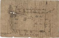
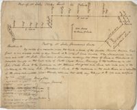
Plat contains 500 acres on the Edisto River. Names associated with this plat are William John Gerardeau, John Stock, William Livingston, Thomas Broughtors, Charles Craven, Charles Parker. Notable geographic locations include South Edisto River and Colleton County.