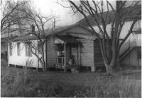
House on site affected by the construction of Interstate 26 (I-26). Address: 11 Maple Street. Surveyor notations on back of photo: "Dkt.: 10.503. Property owner: James L. Tyler. Tract: 54. Station: 5907+50 Rt. Date: Feb. 19, 1963. In R/W - Bought." [See collection description for explanation of surveyor notations.]
House on site affected by the construction of Interstate 26 (I-26).Address: 5 Maple Street. Surveyor notations on back of photo: "Dkt.: 10.503. Property owner: Harry B. Chassereau. Tract: 57. Station: 5907+35 Lt. Date: Feb. 19, 1963." [See collection description for explanation of surveyor notations.]
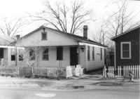
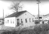
Free Kindergarten on site affected by the construction of Interstate 26 (I-26). Address: 20 Huger Street. Surveyor notations on back of photo: "Dkt.: 10.503. Property owner: Free Kindergarten Assoc. of Chas. Tract: 113. Station: 5936+50 Rt. & Lt. CL. Date: Feb. 20, 1963. In R/W - Bought." [See collection description for explanation of surveyor notations.]
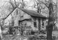
Dilapidated dwelling on site affected by the construction of Interstate 26 (I-26). Address: 22½ Poinsett Street (rear). Surveyor notations on back of photo: "Dkt.: 10.503. Property owner: J.W. Blanchard, Est. Tract: 102. Station: 5921+00 Lt. Date: Feb. 20, 1963. In R/W - Bought." [See collection description for explanation of surveyor notations.]
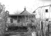
Dilapidated dwelling on site affected by the construction of Interstate 26 (I-26). Address: 22½ Poinsett Street. Surveyor notations on back of photo: "Dkt.: 10.503. Property owner: J.W. Blanchard, Est. Tract: 102. Station: 5921+80 Lt. Date: Feb. 20, 1963. In R/W - Bought." [See collection description for explanation of surveyor notations.]
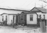
House (rear view) on site affected by the construction of Interstate 26 (I-26). Address: 22 Riker Street. Surveyor notations on back of photo: "Dkt.: 10.503. Property owner: Gibbs Mitchell, Est. Tract: 66. Station: 5910+50 Rt. Date: Feb. 20, 1963. In R/W - Bought." [See collection description for explanation of surveyor notations.]
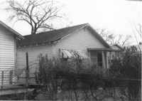
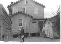
House on site affected by the construction of Interstate 26 (I-26). Address: 22 Riker Street. Surveyor notations on back of photo: "Dkt.: 10.503. Property owner: Gibbs Mitchell, Est. Tract: 66. Station: 5910+50 Rt. Date: Feb. 20, 1963. In R/W - Bought." [See collection description for explanation of surveyor notations.]
Corner grocery store? (side view) on site affected by the construction of Interstate 26 (I-26). Address: 506 Meeting Street (northwest corner of Meeting Street and Sheppard Street). Signage for a gas station in background (partially visible). Surveyor notations on back of photo: "Dkt.: 10.517. Property owner: Rose D. Brady. Tract 64. Station: 5963+50 Lt. - Line 6. Date: March 5, 1963. Partially in R/W." [See collection description for explanation of surveyor notations.]
House (freedman's cottage) and neighboring structures (rear view) on site affected by the construction of Interstate 26 (I-26). Address: 146 Cooper Street. (1951 Sanborn map indicates the address is 94-92A Cooper Street.) Surveyor notations on back of photo: "Dkt.: 10.517. Property owner: Felix J. McKnight, et al. Tract: 65. Station: 5957+85 Lt. - Line 4. Date: March 5, 1963. All in R/W." [See collection description for explanation of surveyor notations.]
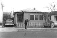
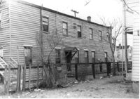
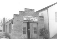
Collins Auto Glass Service on site affected by the construction of Interstate 26 (I-26). Address: 91 Lee Street. Front facade has stepped parapet. Surveyor notations on back of photo: "Dkt.: 10.517. Property owner: W.H. Yon. Tract: 56. Station: 34+30 Lt. - Route 17. Date: February 21, 1963." [See collection description for explanation of surveyor notations.]
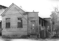
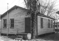
House in dilapidated condition (freedman's cottage) on site affected by the construction of Interstate 26 (I-26). Address: 7 Poinsett Street. Number 23 painted on door. Surveyor notations on back of photo: "Dkt.: 10.503. Property owner: Manuel F. Fernandez. Tract: 106. Station: 5923+50 Lt. Date: Feb. 20, 1963. In R/W - Bought." [See collection description for explanation of surveyor notations.]
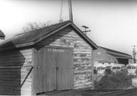
Shed (railroad building) along railroad tracks, on site affected by the construction of Interstate 26 (I-26). Address: 19½ Poinsett Street (rear). Trolley barn on 665 Meeting Street, and buses, in background. Surveyor notations on back of photo: "Dkt.: 10.503. Property owner: S.A.L.R.R. Tract: 105. Station: 5924+40 Rt. & Lt. Date: Feb. 20, 1963." [See collection description for explanation of surveyor notations.]
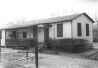
House (corner view, rear) on site affected by the construction of Interstate 26 (I-26). Address: 95 Lee Street. Surveyor notations on back of photo: "Dkt.: 10.517. Property owner: Church of God of Prophecy. Tract: 54. Station: 5955+00 CL. Date: February 21, 1963. In R/W - Bought." [See collection description for explanation of surveyor notations.]
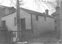
House in dilapidated condition (freedman's cottage) (rear view) on site affected by the construction of Interstate 26 (I-26). Address: 7 Poinsett Street. Surveyor notations on back of photo: "Dkt.: 10.503. Property owner: Manuel F. Fernandez. Tract: 106. Station: 5923+50 Lt. Date: Feb. 20, 1963. In R/W - Bought." [See collection description for explanation of surveyor notations.]
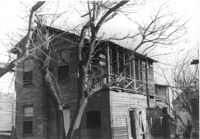
House (corner view, rear) on site affected by the construction of Interstate 26 (I-26). Unnumbered house, on unnamed road, behind 35 Poinsett Street. Trolley barn on 665 Meeting Street, and buses, in background. Surveyor notations on back of photo: "Dkt.: 10.503. Property owner: Manuel F. Fernandez. Tract: 106. Station: 5923+80 Lt. Date: Feb. 20, 1963. In R/W - Bought." [See collection description for explanation of surveyor notations.]
House (rear view) on site affected by the construction of Interstate 26 (I-26). Address: 12 Maple Street. Surveyor notations on back of photo: "Dkt.: 10.503. Property owner: Atlantic Coast Life Ins. Co., et al. Tract: 52. Station: 5906+45 Rt. Date: Feb. 19, 1963. In R/W - Bought." [See collection description for explanation of surveyor notations.]
House (rear view) on site affected by the construction of Interstate 26 (I-26). Address: 8 Maple Street. Surveyor notations on back of photo: "Dkt.: 10.503. Property owner: Atlantic Coast Life Ins. Co., et al. Tract: 50. Station: 5906+30 Rt. Date: Feb. 19, 1963. In R/W - Bought." [See collection description for explanation of surveyor notations.]
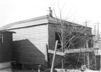
House (rear view) on site affected by the construction of Interstate 26 (I-26). Address: 10 Brigard Street. Surveyor notations on back of photo: "Dkt.: 10.503. Property owner: Nathan Williams. Tract: 43. Station: 5905+30 Rt. Date: Feb. 19, 1963. In R/W - Bought." [See collection description for explanation of surveyor notations.]
House (rear view) on site affected by the construction of Interstate 26 (I-26). Address: 5 Lenox Street. Surveyor notations on back of photo: "Dkt.: 10.503. Property owner: Estelle Thompson. Tract: 40. Station: 5902+60 Lt. Date: Feb. 19, 1963. In R/W - Bought." [See collection description for explanation of surveyor notations.]
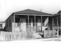
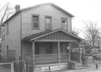
House on site affected by the construction of Interstate 26 (I-26). Address: 11 Brigade Street. Surveyor notations on back of photo: "Dkt.: 10.503. Property owner: Ada Williams. Tract: 42. Station: 5905+20 Rt. Date: Feb. 19, 1963. In R/W - Bought." [See collection description for explanation of surveyor notations.]