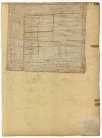
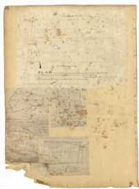
Page 45 of the City Engineer's Plat Book with nine plats. Plat 1 shows lots along New Street, located between Broad Street and Tradd Street, and shows an area labelled "City marshland." Plat 2 shows lots and buildings located between Queen Street and Cliffords Alley. Plat 3 shows land located near the intersection of Washington Street and Smith Street. Plat 4 shows lots and buildings located near the intersection of Green Street and "Comming Street." Plat 5 shows land located between "Boundary (Calhoun) Street" and George Street, and St. Phillip Street and "Comming Street," including a stretch of Green Street and College Street, and a lot labelled "College Lot." Plat 6 shows a lot located on the corner of Queen Street and King Street, and its buildings. Plat 7 shows lots located on Savage Street. Plat 8 shows lots located on Beaufain Street. Plat 9 shows lots near King Street, located between Boulevard Drive and South Bay Street.
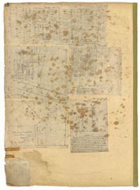
Page 41 of the City Engineer's Plat Book with six plats. Plat 1 shows land between Mount Street and Congress Street, and between a private street and "CITY LANDS Potter's Field." Plat 2 shows lots near Chestnut Street and near Spring Street, Ashton Street, Always Street, Lilly Street, and Pine Street. It also shows a few bodies of water. Plat 3 shows lots near Meeting Street's intersections with Market Alley, and State House Alley. It also labels a court house, the Treasury and Guard House, and St. Michael's Church. Plat 4 shows a stretch of land near President Street, Logan Street, Pinckney Street, Fishburne Street, Mount Street, Congress Street, and shows bodies of water and highlands. Plat 5 shows lots and buildings near the intersection Church Street and Water Street.
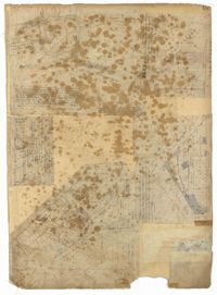
Page 47 of the City Engineer's Plat Book with four plats. Plat 1 shows lots between America Street and Meeting Street, and between Moultrie Street and Line Street. Plat 1 also includes a stretch of Moultrie Street and Hampton Street extending from Meeting Street to King Street. Plat 2 shows the plan of a wharf and channel located on East Bay Street, and includes several planned buildings and structures. Plat 3 shows lots of land located between East Bay Street and the "Edge of Channel of Cooper Street." Plat 4 shows lots located near East Bay Street's intersections with Water Street and Lynches Lane. Plat 4 shows several buildings, "Flat Broken ground," low lands, and a "Shoal dry at Low Water."
Page 49 of the City Engineer's Plat Book with six plats. Plat 1 shows land on the Cooper River. Plat 2 shows land located near Broad Street's intersections with Gadsden Street and Lynch Street, and a stream labelled "Comings Creek." Plat 3 shows wharfs and buildings along the Cooper River and near Champney Street. Plat 4 shows wharves and other structures between East Bay Street and the Cooper River. Plat 5 shows land near South Bay Street's intersections with Meeting Street and Church Street, including a lot labelled "Battery Garden" and a structure labelled "Bathing House."
Page 46 of the City Engineer's Plat Book with five plats. Plat 1 shows lots on Butler Street, between Russell Street and Meeting Street. Plat 2 shows marshland and lots located near Huger Street and "Congress alias Pinckney Street." Plat 3 shows lots located near the intersection of "Rutledge formerly Congress Street" and Huger Street, and also shows Moultrie Street, Pinckney Street, and Legare Street. Plat 4 shows land near the intersection of King Street and Queen Street and several buildings. Plat 5 shows lots between "Hunter now Line" Street, and "Elliot St. now Spring St.," and also shows Rutledge Avenue and Boigard Street.
Page 48 of the City Engineer's Plat Book with five plats. Plat 1 shows lots located between Smith Street and King Street, and Radcliffe Street and Vanderhorst Street, including stretches of Thomas Street, Coming Street, St. Philip Street, and King Street. Plat 2 shows lots and buildings located near the intersection of King Street and South Bay Street. Plat 3 shows land near the intersection between Congress Street and Legare Street, and includes stretches of Hayne Street, Mount Street, and President Street. Plat 3 also shows some land labelled "City Land Potters Field." Plat 4 shows lots and a set of buildings located near Broad Street and Savage Street. Plat 5 shows lots and some buildings located on Gadsden Street.
Page 50 of the City Engineer's Plat Book with seven plats. Plat 1 shows wharves and other structures located on East Bay Street. Plat 2 shows lots and buildings located on the intersection of Tradd Street and Meeting Street. Plat 3 shows lots located near the intersection of Broad Street and Rutledge Street. Plat 4 shows lots and buildings located near Gibbes Street. Plat 5 shows lots located near the intersection of Society Street and East Bay Street. Plat 6 shows lots and buildings near Broad Street. Plat 7 shows lots located between South Bay Street and the Ashley River, near Legare Street.
Page 53 of the City Engineer's Plat Book with five plats. Plat 1 shows shoals and marshlands located near the Ashley River Channel, Gibbes Street, and South Bay Street. Plat 2 features a lot and its buildings at the intersection of Broad Street and New Street. Plat 3 shows a lots and buildings located on Tradd Street. Plat 4 features lots and buildings located near the intersection of Broad Street and Tradd Street, including some stretches of marshland. Plat 5 shows lots located near Broad Street's and Tradd Street's intersections with New Street and Legare Street.