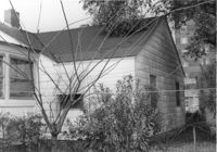
House (rear view) on site affected by the construction of Interstate 26 (I-26). Address: 172 Laurel Avenue. Surveyor notations on back of photo: "Dkt.: 10.503. Property owner: Marguerite E. Jacques. Tract: 13. Station: 5893+20 Lt. Date: Feb. 19, 1963. In R/W - Bought." [See collection description for explanation of surveyor notations.]
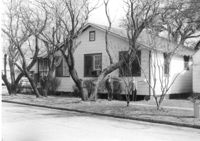
House (side view) on site affected by the construction of Interstate 26 (I-26). Address: 29 Mount Pleasant Street. Joseph Floyd Manor (Mount Pleasant Street and King Street) faintly in background. On corner of on Mount Pleasant Street and King Street. Surveyor notations on back of photo: "Dkt.: 10.503. Property owner: Charles B. Cromer, et al. Tract: 14. Station: 5892+90 Lt. Date: Feb. 19, 1963. In R/W - Bought." [See collection description for explanation of surveyor notations.]
House on site affected by the construction of Interstate 26 (I-26). Address: 29 Mount Pleasant Street. Surveyor notations on back of photo: "Dkt.: 10.503. Property owner: Charles B. Cromer, et al. Tract: 14. Station: 5892+90 Lt. Date: Feb. 19, 1963. In R/W - Bought." [See collection description for explanation of surveyor notations.]
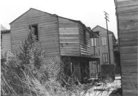
Houses (rear view) on site affected by the construction of the Crosstown. Address: 74½ Cooper Street [74 Cooper Street]. Surveyor notations on back of photo: "Dkt.: 10.518. Property owner: Beatrice Hayward. Tract: 12. Station: 5965+30 Rt. Line 3, S.B. lane of Route 17. Date: Mar. 6, 1963. In R/W - Bought. [See collection description for explanation of surveyor notations.]
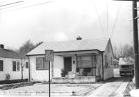
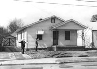
House on site by the construction of Interstate 26 (I-26). Address: 1215 King Street. Surveyor notations on back of photo: "Dkt.: 10.503. Property owner: Mary M.J. Clifton. Tract: 15. Station: 5894+60 Lt. Date: Feb. 19, 1963. In R/W - Bought." [See collection description for explanation of surveyor notations.]
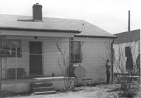
House (rear view) on site by the construction of Interstate 26 (I-26). Address: 1215 King Street. Surveyor notations on back of photo: "Dkt.: 10.503. Property owner: Mary M.J. Clifton. Tract: 15. Station: 5894+60 Lt. Date: Feb. 19, 1963. In R/W - Bought." [See collection description for explanation of surveyor notations.]
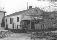
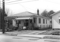
House (rear view) on site by the construction of Interstate 26 (I-26). Address: 1213 King Street. Surveyor notations on back of photo: "Dkt.: 10.503. Property owner: Robert C. Benke, et al. Tract: 16. Station: 5894+90 Lt. Date: Feb. 19, 1963. In R/W - Bought." [See collection description for explanation of surveyor notations.]
Houses on site affected by the construction of the Crosstown. Address: 73 Cooper Street. Surveyor notations on back of photo: "Dkt.: 10.518. Property owner: Centeur Corp. Tract: 13. Station: 5963+90 Rt. Line 3 of the S.B. lane of Route 17. Date: Mar. 6, 1963. Proximity. [See collection description for explanation of surveyor notations.]
House on site by the construction of Interstate 26 (I-26). Address: 1213 King Street. Surveyor notations on back of photo: "Dkt.: 10.503. Property owner: Robert C. Benke, et al. Tract: 16. Station: 5894+90 Lt. Date: Feb. 19, 1963. In R/W - Bought." [See collection description for explanation of surveyor notations.]
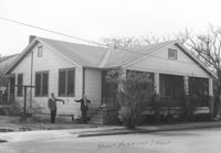
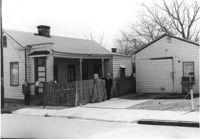
House on site by the construction of Interstate 26 (I-26). Address: 1211 King Street. Surveyor notations on back of photo: "Dkt.: 10.503. Property owner: Albert M. Jones, et al. Tract: 17. Station: 5895+00 Lt. Date: Feb. 19, 1963. In R/W - Bought." [See collection description for explanation of surveyor notations.]
Right of way--South Carolina--Charleston County, Highway planning--South Carolina--Charleston County, Vernacular architecture--South Carolina--Charleston County, Lost architecture--South Carolina--Charleston County, Dwellings--South Carolina--Charleston County✖[remove]463