Copy of plat of 300 acres of land situated in Craven County on the north side of the Santee River bounding north east on Bennett's land and the other sides on vacant land. Names associated with this plat are Susannah Williams, Thomas Ferguson, Moses Bennett, and Benjamin [?]. Notable geographic locations include the Santee River, Craven County [now in parts of Berkeley, Charleston, Georgetown, and Williamsburg counties], and Georgetown.
A collection of five maps and three charts describing land owned by Jonah Horry in South Carolina. The first four maps were drawn from surveys made by John Goddard in 1793; the last map was drawn from a survey made by John Horry Dent in 1836.
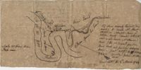
Copy of a tract of 127 acres in the marsh on the Ashepoo River belonging to Sarah McPherson. Little detail included in the plat. Names associated with this plat are Sarah McPherson, Willliam Spense, and Joshua McPherson. Notable geographic locations are the Ashepoo River, Deer Creek, Ladson, and Colleton County.
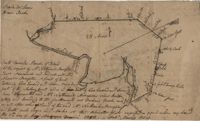
Copy of plan of a plantation on Stono Swamp commonly called Stono Plantation belonging to Thomas Ferguson. Contains 630 acres. Approximately 360 acres is swamp and approximately 270 acres is highland. Names associated with this plat are Thomas Ferguson, George Haig, Joseph Farr, Mary Williams, Smith and John McSweeney. Notable geographic locations include Stono Swamp, Stono Plantation and Charleston.
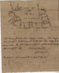
John Grigg 69 Acres Certified for him Feb 28th 1793. John Grigge 69 acres recorded 24 September 1793. Names associated with this plat are John Grigg, William Jones, William Burens, Crompton, H. J. [?] Kennedy, Barnes, Bowels, Somes [?] and John Buren. Notable geographic locations include Fairfield County, Camdon [Camden?] District, and Sawines [?] Creek.
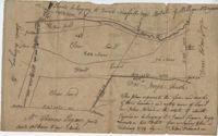
Plan of a tract of land on the NE side of Edisto River called Riverside Plantation and contains 1100 acres belonging to estate of Thomas Ferguson lately sold to Martin. Names associated with this plat included Benjamin Berry, Bull, Martin, John Eberley, Edward Perry, and Thomas Ferguson. Notable geographic locations include St. Paul's Parish, the Edisto River, Parkers Ferry, Public Road to Charleston, Riverside Plantation, and Charleston District.
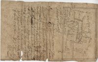
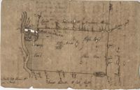
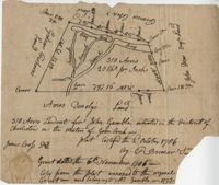
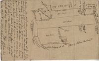
Plat contains 310 acres layer out for John Gamble granted November 6, 1706. Plat contains location of house. Names associated with this plat are John Gamble, Gideon Fishero, Amos Donoly, John Deas, Francis Cobia, Purull, and F. Bremar.
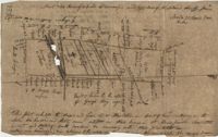
“Plan of parcel of land of late belonging to John Jones and now sold and conveyed by the said Jones to James Carsen for 850 acres but the request of the said Carsen. The said tract of land has been resurveyed and find it to contain but 805 acres of land or there about, so that the original survey must have taken in 45 acres of the marshes of Bohicket River...true copy taken from the original plat in the property of Mr. William Carsen in June 1794." Names associated with this plat are John Carsen, John Jones, James Carsen, William Chambers, James Young, Thomas Winborns, McDoul, Abigail Winborn, John Gibbs, Wilkins, and William Carsen. Notable geographic locations include St. John's Parish, Bohicket River, Wadmalaw River and Johns Island.
Plat contains 211 acres copied from a release form annexed to Nathaniel Broughton to Alexander Broughton. Part of Mulberry Tract. Names associated with this plat are William John Broughton, Nathaniel Broughton, Alexander Broughton and A. Domini. Notable geographic locations include Doken Creek, The Farm, St. John's Parish and Long Branch Creek.
Copy of a plan of a plantation or tract of land lately sold to Isaac Holmes by James Legare lying on Johns Island, Charleston District from a plan annexed to Arleas from Thomas Legare and annexed to Isaac Holmes 1784. 380 acres. Names associated with this plat are Thomas Legare, James Legare, and Isaac Holmes. Notable geographic locations include Charleston District and Johns Island.