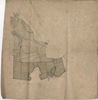
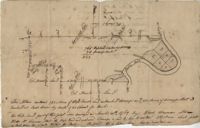
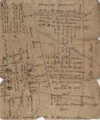
Farm of 54 across for sale by Rutherford, individual plots lettered A-S. Names associated with this plat are Birkman, Rutledge Phokes, Fitch, Kinsman and Rutherford. Notable geographic locations include Broad Street and Dorchester Road.
Office copy of a tract of land once belonging to Thomas Nau then John S. Cripps containing 277 1/2 acres. The land includes gum, white and red oak, and cedar trees along with posts, a rice field and a bridge over the public road from Rantoles [Rantowles] to Charleston. Names associated with this plat include John S. Cripps, Thomas Nau, and S. Lewis.
Plan of Belle Island north of Four Mile Creek consisting of 316 acres. Names associated with this plat are Middleton, Richard Lowndes, and W.R. Maxwell. Notable geographic locations include Belle Isle, Four Mile Creek, and Manquils Creek.
Copy of a plat of 250 acres laid out to Abraham Michau on the north side of Santee River and “now belonging to John Pedro." Names associated with this plat are Abraham Michau, John Pedro, George Hunter and James Glen. Notable geographic locations include the Santee River, Prince Frederick Parish and Georgetown District.
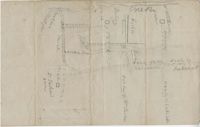
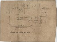
Plat of 53 acres off of Dorchester Road which is divided into lots. Very little details or information. Names associated with this plat are Fitch and Beckman. Notable geographic locations include Dorchester Road.
Resurvey of a tract of land measuring 510 acres called Egan Hall belonging to John Egan situated in St. James Parish, Santee. Names associated with this plat are John Egan, Gredless and Ball. Notable geographic locations include St. James Parish, Santee, Egan Hall, and Bunker's Hill.
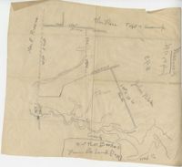
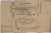
Sketch of property including roads and fields, some specific house names like Rectory house and W. Dotolhinese's house. Names associated with this plat are Glisbe, Priohau, Dotolhinese and Glebe. Notable geographic locations include St. Johns Parish, Broad Road, Wadboo [?] Bridge, Road to Pontauxs, and Road to Cordyville [?].
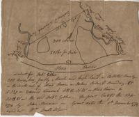
300 acre plot being partly marsh and highland in Colleton County, on the south side it is budding with the Stono River, shows surrounding property owners and minor creeks. Names associated with this plat are Robert Gibbes, Edward Fenwak, John Bremar and Bull.
Copy of a plat of 765 acres of high land and swamp and 98 acres of swamp along Pee Dee River. Names associated with this plat are Colonel Powell, Saxby, Richfield, Wood Furman and Broughton. Notable geographic locations include St. George Parish, the Pee Dee River, Churning Crop Road, Richfield Plantation, and Georgetown District.
Plan of a tract of land belonging to George Chisolm. Names associated with this plat are George Chisolm, John Scott, A. Andrew, Thomas Hollingsby [?], and Thomas. Notable geographic locations include the Ashley River and Kuskawah [Kushiwah] Creek.
Plan of a body of land now part belonging to Mr. George Summers and part to John Summers and part of the estate of Brigdon Smith lying at Stono adjoining lands of S. Matlock. Names associated with this plat are John Summer, George Summer, Brigdon Smith, Malleck, J. Fenwich, Edward Bellinger, Christopher Wilkenson, John Tucker, W. Owen, Henry Hyrne, Inch, Downs, Elizabeth Elliott, George Tommer, Thomas Farr, Smith Mellichamp, and Ann Downs. Notable geographic locations include New Road, St. Paul's Parish and Stono.
Plat consists of 900 acres. Names associated with this plat include Rero A. Stoble, James Bullock and H. Bryan. Notable geographic locations include Savannah and St. Peter's Parish.
300 acres of land belonging to Richard Downes at Stono. Names associated with this plat include Richard Downes, Edmond Bellinger, Thomas Mellichamp, Christopher Welkin and Archibald Stanyarn.
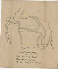
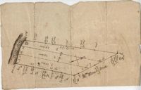
Plat of land belonging to General Cuthbert in the Beaufort District on the Pocotaligo River. Little other detail included in the plat besides the property lines and the river. Names associated with this plat include Luna Cuthbert and Cuthbert.
500 acres surveyed for Thomas Ditom now Paul Blare. Includes Bacon Bridge Road. Names associated with this plat are Paul Blare, Dilton, William Way and Scotte.
Plat of Hopewell Plantation with surrounding lands owned by several people, shows the Edisto River and an unnamed settlement, labels the land in the center as uncleared land while swamps, roads, rivers and trees surround it. Acreage unclear. Names associated with this plat are Baring, Branford, Mellechamp, Colonel W. Hayne and Arthur Middleton. Notable geographic locations are St. Paul's Parish, Edisto River, and Willtown Road.
Plat of two tracts of land (1000 acres) adjoining each other on the north side of the Santee River now belonging to the estate of Brown. Copy from the plat annexed to the orginal grants from the Lords Proprietors. Names associated with this plat are Peter Gaillard, Brown, Henry Bruneau and The Lords Proprietors. Notable geographic locations include the Santee River and Dohov Swamp and Creek.
Three separate 211 acre plots (633 total) of land that are budding and bounding on the south side by the Santee River, shows some trees at the property border and surrounding neighbors. Names associated with this plat are Major Ladson and William Moultrie. Notable geographic locations include the Santee River.
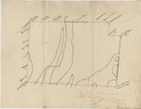
Sketch of land with no measurements or names, shows some trees and unnamed road/creeks. Names associated with this plat are John Michael and J.H. Alston. Notable geographic locations include Santee River and St. James Parish.