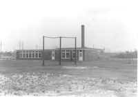
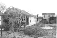
Daniel Jenkins Elementary School, on site affected by the construction of Interstate 26 (I-26). Surveyor notations on back of photo: "Dkt.: 10.490. Property owner: Ashley Development Co. Tract: 1-A. Station: 5775+65 to 5776+60 Lt. Date: September 11, 1962. In R/W - Bought." [See collection description for explanation of surveyor notations.]
Daniel Jenkins Elementary School, on site affected by the construction of Interstate 26 (I-26). Surveyor notations on back of photo: "Dkt.: 10.490. Property owner: V.C. Chemical Co. Tract: 1. Station: 5775+65 to 5776+60 Lt. Date: September 11, 1962. In R/W - Bought." [See collection description for explanation of surveyor notations.]
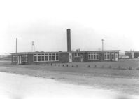
Daniel Jenkins Elementary School, on site affected by the construction of Interstate 26 (I-26). Surveyor notations on back of photo: "Dkt.: 10.490. Property owner: V.C. Chemical Co. Tract: 1. Station: 5776+00 to 5776+40 Rt. Date: September 11, 1962. To be cut off at R/W by owner." [See collection description for explanation of surveyor notations.]
Daniel Jenkins Elementary School, on site affected by the construction of Interstate 26 (I-26). Surveyor notations on back of photo: "Dkt.: 10.490. Property owner: V.C. Chemical Co. Tract: 1. Station: 5776+00 to 5776+40 Rt. Date: September 11, 1962. To be cut off at R/W by owner." [See collection description for explanation of surveyor notations.]
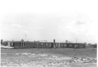
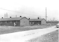
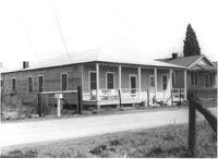
Daniel Jenkins Homes, federal multi-family housing, on Richland Avenue (119 Richland Avenue and 120 Richland Avenue), on site affected by the construction of Interstate 26 (I-26). Surveyor notations on back of photo: "Dkt.: 10.490. Property owner: Ashley Development Co. Tract: 1-A. Station: 5783+10 to 5784+00 Lt. Date: September 11, 1962. To be cut off at R/W by owner." [See collection description for explanation of surveyor notations.]
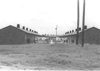
Daniel Jenkins Homes, federal multi-family housing, on Richland Avenue (115 Richland Avenue and 116 Richland Avenue), on site affected by the construction of Interstate 26 (I-26). Surveyor notations on back of photo: "Dkt.: 10.490. Property owner: Ashley Development Co. Tract: 1-A. Station: 5786+50 to 5787+40 Rt. and Lt. Date: September 11, 1962. To be cut off at R/W by owner." [See collection description for explanation of surveyor notations.]
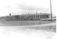
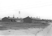
Daniel Jenkins Homes, federal multi-family housing, on Richland Avenue (111 Richland Avenue and 112 Richland Avenue), on site affected by the construction of Interstate 26 (I-26). Surveyor notations on back of photo: "Dkt.: 10.490. Property owner: Ashley Development Co. Tract: 1-A. Station: 5788+35 to 5789+25 Rt. and Lt. Date: September 11, 1962. In R/W - Bought." [See collection description for explanation of surveyor notations.]
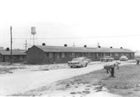
Daniel Jenkins Homes, federal multi-family housing, on Richland Avenue (113 Richland Avenue and 114 Richland Avenue), on site affected by the construction of Interstate 26 (I-26). Surveyor notations on back of photo: "Dkt.: 10.490. Property owner: Ashley Development Co. Tract: 1-A. Station: Rt. 5788+00. Date: September 11, 1962. In R/W - Bought." [See collection description for explanation of surveyor notations.]
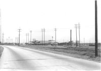
Road (presumably King Street Extn.) to Virginia-Carolina Chemical Corp. with its buildings in background, on site affected by the construction of Interstate 26 (I-26). Surveyor notations on back of photo: "Dkt.: 10.490. Property owner: V.C. Chemical Co. Tract: 1. Station: Panoramic view from North (see plans). Date: September 11, 1962. (For information.)" [See collection description for explanation of surveyor notations.]
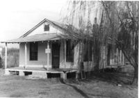
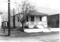
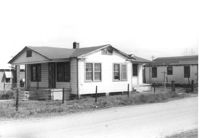
House on site affected by the construction of Interstate 26 (I-26). Surveyor notations on back of photo: "Dkt.: 10.490. Property owner: Robert M. Huckabee. Tract: 14. Station: 5818+00 (Lt. Line "G"). Date: March 22, 1962. In R/W - Bought." [See collection description for explanation of surveyor notations.]
House (rear view) on site affected by the construction of Interstate 26 (I-26). Surveyor notations on back of photo: "Dkt.: 10.490. Property owner: Robert M. Huckabee. Tract: 14. Station: 5818+00 (Lt. Line "G"). Date: March 22, 1962. In R/W - Bought." [See collection description for explanation of surveyor notations.]
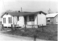
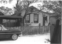
House on site affected by the construction of Interstate 26 (I-26). Surveyor notations on back of photo: "Dkt.: 10.490. Property owner: Kate Metts. Tract: 15. Station: 5818+20 Rt. Date: March 22, 1962. In R/W - Bought." [See collection description for explanation of surveyor notations.]
House (rear view) on site affected by the construction of Interstate 26 (I-26). Surveyor notations on back of photo: "Dkt.: 10.490. Property owner: Kate Metts. Tract: 15. Station: 5818+20 Rt. Date: March 22, 1962. In R/W - Bought." [See collection description for explanation of surveyor notations.]
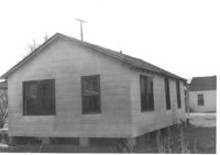
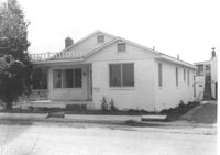
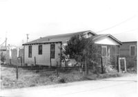
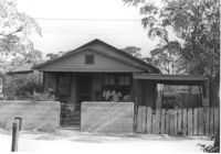
House on site affected by the construction of Interstate 26 (I-26). Surveyor notations on back of photo: "Dkt.: 10.490. Property owner: Charles L. Smith. Tract: 16. Station: 5818+20 Lt. Date: March 22, 1962. In R/W - Bought." [See collection description for explanation of surveyor notations.]
House (rear view) on site affected by the construction of Interstate 26 (I-26). Surveyor notations on back of photo: "Dkt.: 10.490. Property owner: Charles L. Smith. Tract: 16. Station: 5818+20 Lt. Date: March 22, 1962. In R/W - Bought." [See collection description for explanation of surveyor notations.]
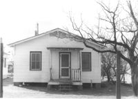
House on site affected by the construction of Interstate 26 (I-26). Building address number 2202. Surveyor notations on back of photo: "Dkt.: 10.490. Property owner: Julius A. Cercoply. Tract: 17. Station: 5818+20 Lt. Date: March 22, 1962. In R/W - Bought." [See collection description for explanation of surveyor notations.]
House on site affected by the construction of Interstate 26 (I-26). Building address number 2202. Surveyor notations on back of photo: "Dkt.: 10.490. Property owner: Julius A. Cercoply. Tract: 17. Station: 5818+20 Lt. Date: March 22, 1962. In R/W - Bought." [See collection description for explanation of surveyor notations.]
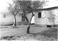
House (rear view) yard, and shed, on site affected by the construction of Interstate 26 (I-26). [Building address number 2202]. Surveyor notations on back of photo: "Dkt.: 10.490. Property owner: Julius A. Cercoply. Tract: 17. Station: 5818+20 Lt. Date: March 22, 1962. In R/W - Bought." [See collection description for explanation of surveyor notations.]
House on site affected by the construction of Interstate 26 (I-26). Surveyor notations on back of photo: "Dkt.: 10.490. Property owner: Joe B. Cusak, Jr. Tract: 18. Station: 5819+85 Lt. Date: March 22, 1962. In R/W - Bought." [See collection description for explanation of surveyor notations.]
House (rear view) on site affected by the construction of Interstate 26 (I-26). Surveyor notations on back of photo: "Dkt.: 10.490. Property owner: Joe B. Cusak, Jr. Tract: 18. Station: 5819+85 Lt. Date: March 22, 1962. In R/W - Bought." [See collection description for explanation of surveyor notations.]
House on site affected by the construction of Interstate 26 (I-26). Surveyor notations on back of photo: "Dkt.: 10.490. Property owner: Ernest L. Bailey. Tract: 19. Station: 5819+30 Lt. Date: March 22, 1962. In R/W - Bought." [See collection description for explanation of surveyor notations.]
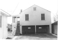
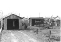
Garage and garage apartment on site affected by the construction of Interstate 26 (I-26). Surveyor notations on back of photo: "Dkt.: 10.490. Property owner: Ernest L. Bailey. Tract: 19. Station: 5819+80 on CL. Date: March 22, 1962. In R/W - Bought." [See collection description for explanation of surveyor notations.]
House (rear view) on site affected by the construction of Interstate 26 (I-26). Surveyor notations on back of photo: "Dkt.: 10.490. Property owner: Ernest L. Bailey. Tract: 19. Station: 5819+30 Lt. Date: March 22, 1962. In R/W - Bought." [See collection description for explanation of surveyor notations.]
House (corner view, rear) on site affected by the construction of Interstate 26 (I-26). Surveyor notations on back of photo: "Dkt.: 10.490. Property owner: Ernest L. Bailey. Tract: 19. Station: 5819+80 on CL. Date: March 22, 1962. In R/W - Bought." [See collection description for explanation of surveyor notations.]
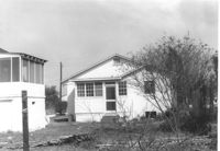
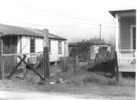
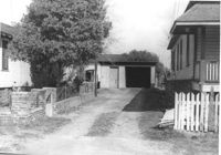
Garage or shed on site affected by the construction of Interstate 26 (I-26). Surveyor notations on back of photo: "Dkt.: 10.490. Property owner: Joseph F. Smith. Tract: 20. Station: 5819+82 on Lt. of line "G." Date: March 22, 1962. In R/W - Bought." [See collection description for explanation of surveyor notations.]
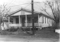
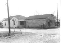
Joe Smith's Grocery, at the corner of Doscher Avenue and Farwell Street, on site affected by the construction of Interstate 26 (I-26). [Building address number 1934.] House to its rear also in photo. Surveyor notations on back of photo: "Dkt.: 10.490. Property owner: Joseph F. Smith. Tract: 21. Station: 5819+00 Rt. Line "G." Date: March 22, 1962. In R/W - Bought." [See collection description for explanation of surveyor notations.]
Joe Smith's Grocery [at the corner of Doscher Avenue and Farwell Street] on site affected by the construction of Interstate 26 (I-26). Building address number 1934. Surveyor notations on back of photo: "Dkt.: 10.490. Property owner: Joseph F. Smith. Tract: 21. Station: 5819+00 Rt. Line "G." Date: March 22, 1962. In R/W - Bought." [See collection description for explanation of surveyor notations.]
House (rear view) behind Joe Smith's Grocery, on site affected by the construction of Interstate 26 (I-26). Surveyor notations on back of photo: "Dkt.: 10.490. Property owner: Joseph F. Smith. Tract: 21. Station: 5819+00 Rt. Line "G." Date: March 22, 1962. In R/W - Bought." [See collection description for explanation of surveyor notations.]
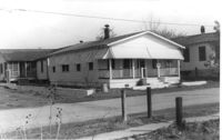
House on site affected by the construction of Interstate 26 (I-26). Surveyor notations on back of photo: "Dkt.: 10.490. Property owner: William N. Harrell. Tract: 22. Station: 5819+40 on CL Line "G." Date: March 22, 1962. In R/W - Bought." [See collection description for explanation of surveyor notations.]
House (rear view) on site affected by the construction of Interstate 26 (I-26). Surveyor notations on back of photo: "Dkt.: 10.490. Property owner: William N. Harrell. Tract: 22. Station: 5819+40 on CL Line "G." Date: March 22, 1962. In R/W - Bought." [See collection description for explanation of surveyor notations.]
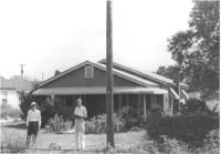
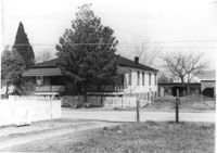
House on site affected by the construction of Interstate 26 (I-26). Surveyor notations on back of photo: "Dkt.: 10.490. Property owner: Myrtices S. Williams. Tract: 23. Station: 5820+00 Rt. Date: August 29, 1962. Bought." [See collection description for explanation of surveyor notations.]
House (rear view) on site affected by the construction of Interstate 26 (I-26). Surveyor notations on back of photo: "Dkt.: 10.490. Property owner: Myrtices S. Williams. Tract: 23. Station: 5820+00 Rt. Date: August 29, 1962. Bought." [See collection description for explanation of surveyor notations.]
House on site affected by the construction of Interstate 26 (I-26). Surveyor notations on back of photo: "Dkt.: 10.490. Property owner: Margaret Ehrardt. Tract: 24. Station: 5820+55 Rt. Line "G." Date: March 22, 1962. In R/W - Bought." [See collection description for explanation of surveyor notations.]
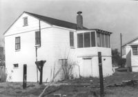
House (side view) on site affected by the construction of Interstate 26 (I-26). Surveyor notations on back of photo: "Dkt.: 10.490. Property owner: Margaret Ehrardt. Tract: 24. Station: 5820+55 Rt. Line "G." Date: March 22, 1962. In R/W - Bought." [See collection description for explanation of surveyor notations.]
House on site affected by the construction of Interstate 26 (I-26). Surveyor notations on back of photo: "Dkt.: 10.490. Property owner: James and Joseph Davis. Tract: 25. Station: 5820+50 Lt. Line "G." Date: March 22, 1962. In R/W - Bought." [See collection description for explanation of surveyor notations.]
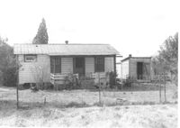
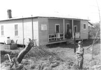
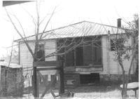
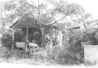
House, driveway, and shed on site affected by the construction of Interstate 26 (I-26). Surveyor notations on back of photo: "Dkt.: 10.490. Property owner: James and Joseph Davis. Tract: 25. Station: 5820+50 Lt. Line "G." Date: March 22, 1962. In R/W - Bought." [See collection description for explanation of surveyor notations.]
House on site affected by the construction of Interstate 26 (I-26). Surveyor notations on back of photo: "Dkt.: 10.490. Property owner: Ruth V. Cooper. Tract: 26. Station: 5820+50 on CL. Date: March 22, 1962. In R/W - Bought." [See collection description for explanation of surveyor notations.]
House (rear view) on site affected by the construction of Interstate 26 (I-26). Surveyor notations on back of photo: "Dkt.: 10.490. Property owner: Ruth V. Cooper. Tract: 26. Station: 5820+50 on CL. Date: March 22, 1962. In R/W - Bought." [See collection description for explanation of surveyor notations.]
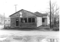
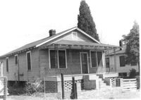
House on site affected by the construction of Interstate 26 (I-26). Building address number 2204. Surveyor notations on back of photo: "Dkt.: 10.490. Property owner: Joseph B. Cusack, Jr. Tract: 27. Station: 5820+50 Lt. Date: March 22, 1962. In R/W - Bought." [See collection description for explanation of surveyor notations.]
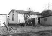
House, driveway, and shed/garage on site affected by the construction of Interstate 26 (I-26). Surveyor notations on back of photo: [Address number 2204.] "Dkt.: 10.490. Property owner: Joseph B. Cusack, Jr. Tract: 27. Station: 5820+50 Lt. Date: March 22, 1962. In R/W - Bought." [See collection description for explanation of surveyor notations.]
House (rear view) on site affected by the construction of Interstate 26 (I-26). [Building address number 2204.] Surveyor notations on back of photo: "Dkt.: 10.490. Property owner: Joseph B. Cusack, Jr. Tract: 27. Station: 5820+50 Lt. Date: March 22, 1962. In R/W - Bought." [See collection description for explanation of surveyor notations.]
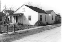
House on site affected by the construction of Interstate 26 (I-26). View from lot across the street. Surveyor notations on back of photo: "Dkt.: 10.490. Property owner: Mary F. Mitchum. Tract: 27-A. Station: 5820+50 Lt. Date: March 22, 1962. In R/W - Bought." [See collection description for explanation of surveyor notations.]
House (rear view) on site affected by the construction of Interstate 26 (I-26). Surveyor notations on back of photo: "Dkt.: 10.490. Property owner: Mary F. Mitchum. Tract: 27-A. Station: 5820+50 Lt. Date: March 22, 1962. In R/W - Bought." [See collection description for explanation of surveyor notations.]
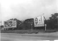
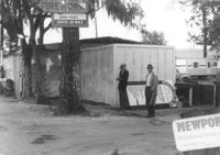
Swift's Ice Cream and "Oil Heat is Safe" billboards on lot on Spruill Avenue at Irving Avenue, on site affected by the construction of Interstate 26 (I-26). Surveyor notations on back of photo: "Dkt.: 10.490. Property owner: Arabelle Simmons, Est. Tract: 28. Date: September 12, 1962. To be moved by owner." [See collection description for explanation of surveyor notations.]
McFadden Open Air Market, on site affected by the widening of Route 171 (Folly Road). Surveyor notations on back of photo: "Dkt.: 10.494. Property owner: Margaret H. Heirs. Tract: 44. Station: 175+50 Lt. Date: Mar. 21, 1962. Proximity. [See collection description for explanation of surveyor notations.]
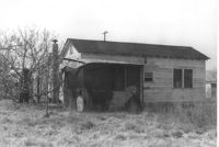
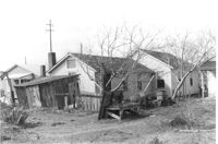
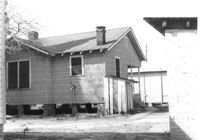
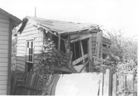
House in dilapidated condition, on site affected by the construction of Interstate 26 (I-26). Surveyor notations on back of photo: "Dkt.: 10.490. Property owner: Robert Ladson, et al. Tract: 29. Station: 5794+20 on CL Line A. Date: September 11, 1962. In R/W - Bought." [See collection description for explanation of surveyor notations.]
House in dilapidated condition (rear view), on site affected by the construction of Interstate 26 (I-26). Surveyor notations on back of photo: "Dkt.: 10.490. Property owner: Robert Ladson, et al. Tract: 29. Station: 5794+20 on CL Line A. Date: September 11, 1962. In R/W - Bought." [See collection description for explanation of surveyor notations.]
House (rear view) on site affected by the construction of Interstate 26 (I-26). Surveyor notations on back of photo: "Dkt.: 10.490. Property owner: Rev. Andrew Johnson, et al. Tract: 30. Station: 5794+45 on CL Line 'A'. Date: September 11, 1962. In R/W - Bought." [See collection description for explanation of surveyor notations.]
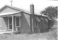
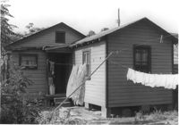
House on site affected by the construction of Interstate 26 (I-26). Surveyor notations on back of photo: "Dkt.: 10.490. Property owner: Rev. Andrew Johnson, et al. Tract: 30. Station: 5794+45 on CL Line 'A'. Date: September 11, 1962. In R/W - Bought." [See collection description for explanation of surveyor notations.]
House on site affected by the construction of Interstate 26 (I-26). Surveyor notations on back of photo: "Dkt.: 10.490. Property owner: Anna Broderick. Tract: 31. Station: 5794+75 on CL Line 'A'. Date: September 11, 1962. In R/W - Bought." [See collection description for explanation of surveyor notations.]