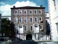
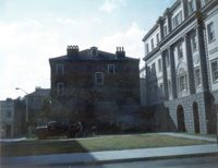
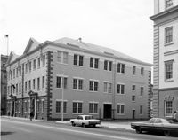
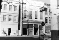
Fireproof Building (South Carolina Historical Society), 100 Meeting Street. View of SW (Side and Front) elevation. Charleston, S.C.;3.5" x 5" B/W photo. Box 5, Folder 2-1-1. One copy.
Fireproof Building (South Carolina Historical Society), 100 Meeting Street. View of SW (Front and Side) elevation. Charleston, S.C.;3.5" x 5" B/W photo. Box 5, Folder 2-1-1. One copy.
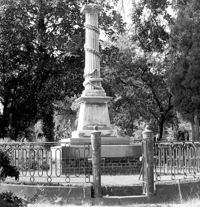
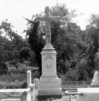
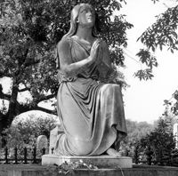
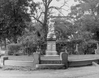
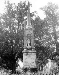
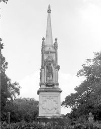
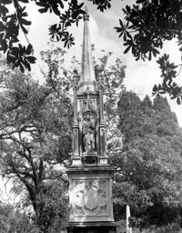
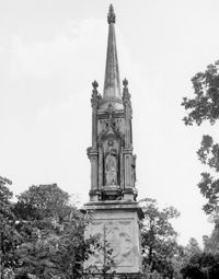
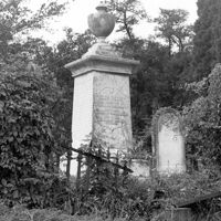
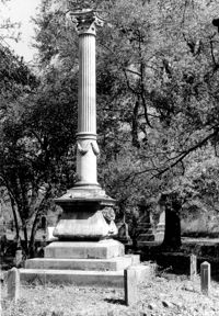
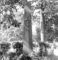
Magnolia Cemetery, Huguenin Avenue and Algonquin Road. Monument of Colonel William Washington. View of South elevation. Charleston, S.C.;8" x 8" B/W photo. Box 5, Folder 2-1-3. One copy.
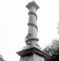
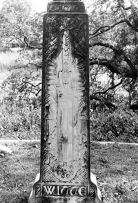
Magnolia Cemetery, Huguenin Avenue and Algonquin Road. Monument of Colonel William Washington. Detail View of column. South elevation. Charleston, S.C.;8" x 8" B/W photo. Box 5, Folder 2-1-3. Three copies.
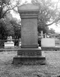
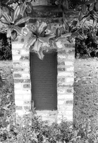
Magnolia Cemetery, Huguenin Avenue and Algonquin Road. Tombstone of William Gilmore Simms. Charleston, S.C.;10" x 8" B/W photo. Box 5, Folder 2-1-3. One copy.
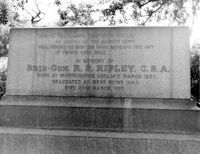
Magnolia Cemetery, Huguenin Avenue and Algonquin Road. Tombstone of R.S. Ripley. View of South elevation. Charleston, S.C.;8" x 10" B/W photo. Box 5, Folder 2-1-3. One copy.
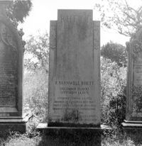
Magnolia Cemetery, Huguenin Avenue and Algonquin Road. Tombstone of R. Barnwell Rhett. View of ESE elevation. Charleston, S.C.;8" x 8" B/W photo. Box 5, Folder 2-1-3. One copy.
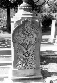
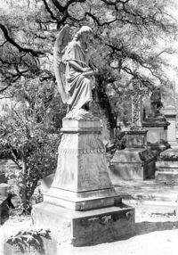
Magnolia Cemetery, Huguenin Avenue and Algonquin Road. Monument of Emma Heyward Haskell. Charleston, S.C.;8" x 8" B/W photo. Box 5, Folder 2-1-3. One copy.
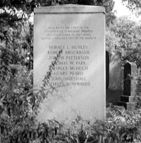
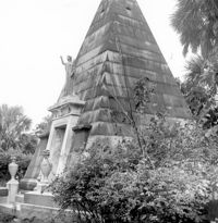
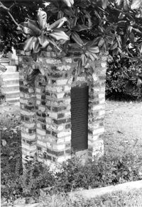
Magnolia Cemetery, Huguenin Avenue and Algonquin Road. Hunley Monument. View of North elevation. Charleston, S.C.;8" x 8" B/W photo. Box 5, Folder 2-1-3. One copy.
Magnolia Cemetery, Huguenin Avenue and Algonquin Road. Tombstone of Elizabeth DeSaussure Tucker. Charleston, S.C.;10" x 8" B/W photo. Box 5, Folder 2-1-3. One copy.
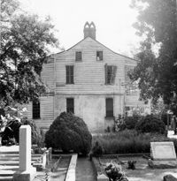
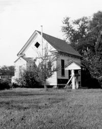
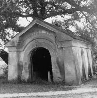
Magnolia Cemetery, Huguenin Avenue and Algonquin Road. Chapel - View of Side and Rear elevation. Charleston, S.C.;10" x 8" B/W photo. Box 5, Folder 2-1-3. One copy.
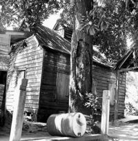
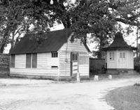
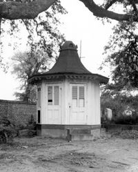
Magnolia Cemetery, Huguenin Avenue and Algonquin Road. Pump House and Gazebo - View of NW (Front and Side) elevation. Charleston, S.C.;8" x 10" B/W photo. Box 5, Folder 2-1-3. One copy.
Magnolia Cemetery, Huguenin Avenue and Algonquin Road. Monument of Ellen Turner, ca. 1898. View of Front and Side elevation. Charleston, S.C.;10" x 6.5" B/W photo. Box 5, Folder 2-1-3. One copy.
Magnolia Cemetery, Huguenin Avenue and Algonquin Road. Monument of Sarah F., Charles F., and Elbert P. Jones. View of South elevation. Charleston, S.C.;10" x 8" B/W photo. Box 5, Folder 2-1-3. One copy.
Magnolia Cemetery, Huguenin Avenue and Algonquin Road. Monument of Sarah F., Charles F., and Elbert P. Jones. View of West elevation. Charleston, S.C.;10" x 8" B/W photo. Box 5, Folder 2-1-3. One copy.
Magnolia Cemetery, Huguenin Avenue and Algonquin Road. Monument of Sarah F., Charles F., and Elbert P. Jones. View of North elevation. Charleston, S.C.;10" x 8" B/W photo. Box 5, Folder 2-1-3. One copy.
Magnolia Cemetery, Huguenin Avenue and Algonquin Road. Monument of Sarah F., Charles F., and Elbert P. Jones. View of East elevation. Charleston, S.C.;10" x 8" B/W photo. Box 5, Folder 2-1-3. One copy.
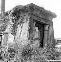
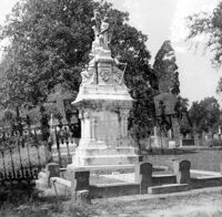
Magnolia Cemetery, Huguenin Avenue and Algonquin Road. Gibbes Mausoleum. View of Front elevation. Charleston, S.C.;8" x 8" B/W photo. Box 5, Folder 2-1-3. One copy.
Magnolia Cemetery, Huguenin Avenue and Algonquin Road. Tombstone of Thomas Bennett. View of Front and Side elevation. Charleston, S.C.;8" x 8" B/W photo. Box 5, Folder 2-1-3. One copy.
Magnolia Cemetery, Huguenin Avenue and Algonquin Road. Vanderhorst Mausoleum. View of Front and Side elevation. Charleston, S.C.;8" x 8" B/W photo. Box 5, Folder 2-1-3. One copy.
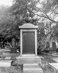
Magnolia Cemetery, Huguenin Avenue and Algonquin Road. Monument of William Ashmead Courtenay. View of Front elevation. Charleston, S.C.;10" x 8" B/W photo. Box 5, Folder 2-1-3. One copy.
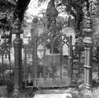
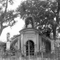
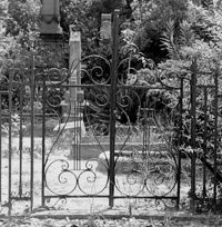
Magnolia Cemetery, Huguenin Avenue and Algonquin Road. Trapier-Jervey Gate. View of Front elevation. Charleston, S.C.;8" x 8" B/W photo. Box 5, Folder 2-1-3. One copy.
Magnolia Cemetery, Huguenin Avenue and Algonquin Road. William B. Smith Mausoleum. View of Side and Front elevation. Charleston, S.C.;8" x 8" B/W photo. Box 5, Folder 2-1-3. One copy.
Magnolia Cemetery, Huguenin Avenue and Algonquin Road. Monument of Hugh Swinton Legare. View of Front and Side elevation. Charleston, S.C.;10" x 6.5" B/W photo. Box 5, Folder 2-1-3. One copy.
Magnolia Cemetery, Huguenin Avenue and Algonquin Road. Tombstone of Birt family. View of Front elevation. NOTE: Print has superimposed second image. Charleston, S.C.;8" x 8" B/W photo. Box 5, Folder 2-1-3. Two copies.
Magnolia Cemetery, Huguenin Avenue and Algonquin Road. Tombstone of Micah Jenkins. View of Front elevation. Charleston, S.C.;8" x 8" B/W photo. Box 5, Folder 2-1-3. One copy.
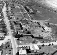
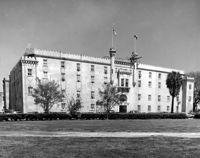
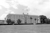
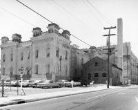
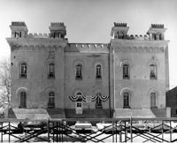
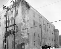
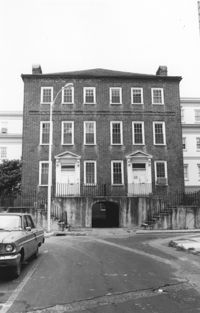
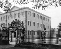
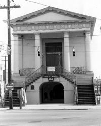
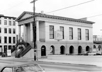
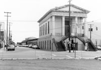
Old Citadel (South Carolina State Arsenal, Embassy Suites Hotel), 337 Meeting Street. View of SW (Front and Side) elevation. Charleston, S.C.;3.5" x 5" B/W photo. Box 5, Folder 2-1-5. Two copies.
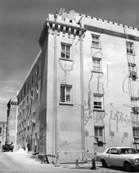
Old Citadel (South Carolina State Arsenal, Embassy Suites Hotel), 337 Meeting Street. View of SW (Front and Side) elevation. Charleston, S.C.;8" x 10" B/W photo. Box 5, Folder 2-1-5. Three copies.
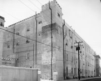
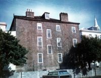
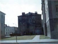
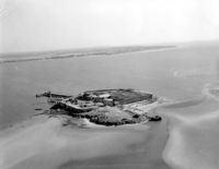
Old Citadel (South Carolina State Arsenal, Embassy Suites Hotel), 337 Meeting Street. View of NE (Rear and Side) elevation. Charleston, S.C.;8" x 10" B/W photo. Box 5, Folder 2-1-5. One copy.
Old Citadel (South Carolina State Arsenal, Embassy Suites Hotel), 337 Meeting Street. View of NE (Rear and Side) elevation. Charleston, S.C.;8" x 10" B/W photo. Box 5, Folder 2-1-5. Two copies.
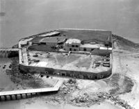
Old Citadel (South Carolina State Arsenal, Embassy Suites Hotel), 337 Meeting Street. View of North (Rear) elevation. Charleston, S.C.;8" x 10" B/W photo. Box 5, Folder 2-1-5. One copy.
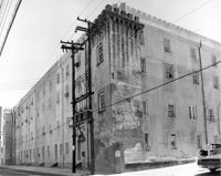
Old Citadel (South Carolina State Arsenal, Embassy Suites Hotel), 337 Meeting Street. View of NW (Side and Rear) elevation. Charleston, S.C.;8" x 10" B/W photo. Box 5, Folder 2-1-5. One copy.
Old Citadel (South Carolina State Arsenal, Embassy Suites Hotel), 337 Meeting Street. View of NW (Side and Rear) elevation. Charleston, S.C.;8" x 10" B/W photo. Box 5, Folder 2-1-5. One copy.
Old Citadel (South Carolina State Arsenal, Embassy Suites Hotel), 337 Meeting Street. View of SW (Front and Side) elevation. Charleston, S.C.;10" x 8" B/W photo. Box 5, Folder 2-1-5. One copy.
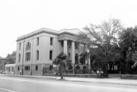
Charleston County Courthouse, 77 Meeting Street. View of NE (Side and Front) elevation. Charleston, S.C.;8" x 10" B/W photo. Box 5, Folder 2-1-8. One copy.
Charleston County Courthouse, 77 Meeting Street. View from Washington Square Park - NE (Front and Side) elevation. Charleston, S.C.;8" x 10" B/W photo. Box 5, Folder 2-1-8. One copy.
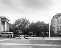
Washington Square Park, NE corner of Broad and Meeting Streets. View of West (Meeting Street) elevation. Charleston, S.C.;8" x 10" B/W photo. Box 5, Folder 2-1-8. One copy.
Old Citadel (South Carolina State Arsenal, Embassy Suites Hotel), 337 Meeting Street. View of Interior Courtyard. Charleston, S.C.;8" x 10" B/W photo. Box 5, Folder 2-1-5. One copy.
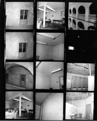
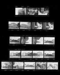
Charleston County Courthouse, 77 Meeting Street. Contact Sheet - Views of the Courthouse and Washington Square Park. Charleston, S.C.;10" x 8" B/W photo. Box 5, Folder 2-1-8. One copy.
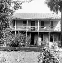
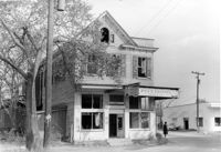
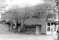
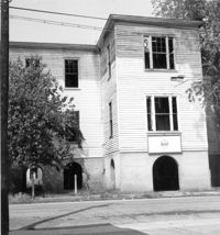
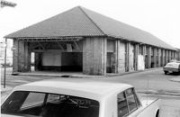
Firetag's Store (Mappus' Store, Six Mile Store) - View of NE (Front and Side) elevation. North Charleston, S.C.;6.5" x 10" B/W photo. Box 5, Folder 2-1-7. One copy.
Firetag's Store (Mappus' Store, Six Mile Store), Success Street (between Meeting Street Road and Rivers Avenue). View of West (Side) elevation. North Charleston, S.C.;6.5" x 10" B/W photo. Box 5, Folder 2-1-7. One copy.
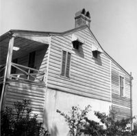
Firetag's Store (Mappus' Store, Six Mile Store), Success Street (between Meeting Street Road and Rivers Avenue). View of SW (Rear and Side) elevation. North Charleston, S.C.;6.5" x 10" B/W photo. Box 5, Folder 2-1-7. One copy.
Firetag's Store (Mappus' Store, Six Mile Store), Success Street (between Meeting Street Road and Rivers Avenue). View of East (Side) elevation. North Charleston, S.C.;6.5" x 10" B/W photo. Box 5, Folder 2-1-7. One copy.
Quarter House Fort & Tavern Site, Success Street (between Meeting Street Road and Rivers Avenue). Detail View of Tavern Entrance Post and Historical Marker. Front and Side elevation. North Charleston, S.C.;10" x 6.5" B/W photo. Box 5, Folder 2-1-10. One copy.
Quarter House Fort & Tavern Site, Success Street (between Meeting Street Road and Rivers Avenue). Detail View of Tavern Entrance Post and Historical Marker. Front elevation. North Charleston, S.C.;10" x 6.5" B/W photo. Box 5, Folder 2-1-10. One copy.
Quarter House Fort & Tavern Site, Success Street (between Meeting Street Road and Rivers Avenue). View of SE elevation. North Charleston, S.C.;6.5" x 10" B/W photo. Box 5, Folder 2-1-10. One copy.
Quarter House Fort & Tavern Site, Success Street (between Meeting Street Road and Rivers Avenue). View of SE elevation. North Charleston, S.C.;6.5" x 10" B/W photo. Box 5, Folder 2-1-10. One copy.
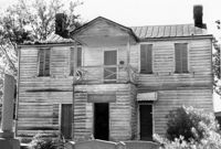
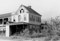
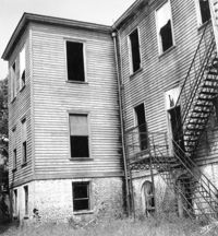
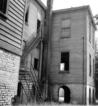
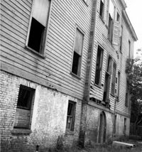
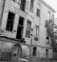
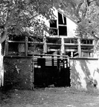
Shaw Community Center, 22 Mary Street. Main Building - View of North (Front) elevation. Charleston, S.C. (NOTE: Structure demolished in 1974);8.25" x 7.5" B/W photo. Box 6, Folder 2-1-13. One copy.
Shaw Community Center, 22 Mary Street. Main Building - View of SW (Rear and Side) elevation. Charleston, S.C. (NOTE: Structure demolished in 1974);8.25" x 7.5" B/W photo. Box 6, Folder 2-1-13. One copy.
Shaw Community Center, 22 Mary Street. Main Building - View of SE (Side and Rear) elevation. Charleston, S.C. (NOTE: Structure demolished in 1974);8.25" x 7.5" B/W photo. Box 6, Folder 2-1-13. One copy.
Shaw Community Center, 22 Mary Street. Main Building - View of South (Rear) elevation, looking West. Charleston, S.C. (NOTE: Structure demolished in 1974);8.25" x 7.5" B/W photo. Box 6, Folder 2-1-13. One copy.
Shaw Community Center, 22 Mary Street. Main Building - View of South (Rear) elevation. Charleston, S.C. (NOTE: Structure demolished in 1974);8.25" x 7.5" B/W photo. Box 6, Folder 2-1-13. One copy.
Shaw Community Center, 22 Mary Street. Coach House - View of NW elevation. Charleston, S.C. (NOTE: Structure demolished in 1974);8.25" x 7.5" B/W photo. Box 6, Folder 2-1-13. One copy.
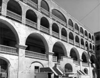
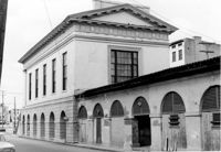
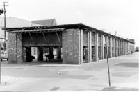
City Market - Market Hall and First Section of Sheds. View of SE (Side and Rear) elevation. Charleston, S.C.;8" x 10" B/W photo. Box 6, Folder 2-1-14. One copy.
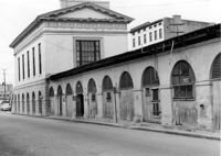
City Market - Market Hall and First Section of Sheds. View of South (Side) elevation, looking East. Charleston, S.C.;6.5" x 10" B/W photo. Box 6, Folder 2-1-14. One copy.
City Market - Market Hall and First Section of Sheds. View of South (Side) elevation, looking East. Charleston, S.C.;6.5" x 10" B/W photo. Box 6, Folder 2-1-14. One copy.
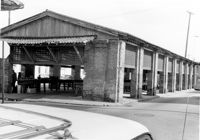
City Market - Market Hall and Second Section of Sheds. View of SW (Front and Side) elevation. Charleston, S.C.;6.5" x 10" B/W photo. Box 6, Folder 2-1-14. One copy.
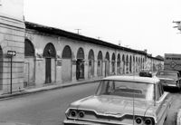
City Market - Market Hall and Third Section of Sheds. View of SW (Front and Side) elevation. Charleston, S.C.;6.5" x 10" B/W photo. Box 6, Folder 2-1-14. One copy.
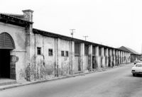
City Market - Market Hall and Fourth Section of Sheds. View of SW (Front and Side) elevation. Charleston, S.C.;6.5" x 10" B/W photo. Box 6, Folder 2-1-14. One copy.
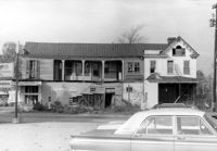
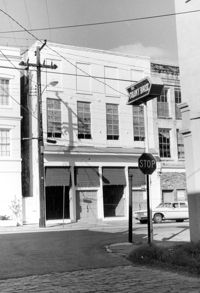
McCrady's Tavern and Long Room, 153 East Bay Street. View of South (Front) elevation (looking West from East Bay Street). Charleston, S.C.;10" x 6.5" B/W photo. Box 6, Folder 2-1-31. One copy.
McCrady's Tavern and Long Room, 153 East Bay Street. View of SW (Side and Front) elevation. Charleston, S.C.;6.5" x 10" B/W photo. Box 6, Folder 2-1-31. One copy.