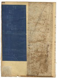
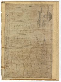
Page 148 of the City Engineer's Plat Book with two plats. Plat 1 shows lots and structures located on and near Calhoun Street, between Washington Street and the Cooper River. Plat two shows "Lots in the Village of Rikersville," including 21 acres of marshland, a canal, and a pond.
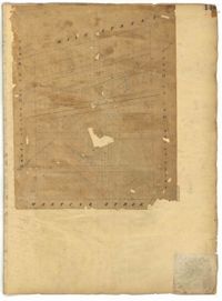
Page 149 of the City Engineer's Plat Book with one plat. The plat shows lots located between Meeting Street and King Street, including a stretch of railroad.
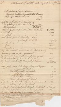
Statement of receipts and expenditures for the construction of Vernizobre Bank ("bank" believed to refer to a river bank or dyke). Earliest date appearing on the document is an expenditure to the contractor in 1854. 2p.
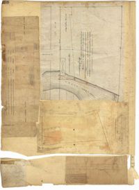
Page 158 of the City Engineer's Plat Book with four plats. Plat 1 shows lots located on South Street, near where it intersects with Hanover Street. Plat 2 shows lots located on and near Mill Street, near its intersections with Lucas Street and President Street, and shows a building labelled "Dead House" and a creek labeled as "leading to canal." Plat 3 shows lots and structures located on East Bay Street. Plat 4 shows South Bay Street and its intersections with Legare Street and King Street.
Page 61 of the City Engineer's Plat Book with four plats. Plat 1 features a lot and buildings located between East Bay Street and Concord Street, and between Pritchard Street and Hasell Street. Plat 2 shows lots between Pritchard Street and Hard Alley, near their intersections with East Bay Street. Plat 3 shows lots located on Pritchard Street, between East Bay Street and Concord Street, with some buildings labelled. Plat 4 shows lots located near the intersection of Meeting Street and Queen Street with some buildings and structures labelled.
Page 29 of the City Engineer's Plat Book with three plats. Plat 1 shows lots and structures located near Calhoun Street, Rutledge Street, Lynch Street, Gadsden Street, Lucas Street, and Bennett Street, including a lot labelled "Public Square," a creek, and a building labelled "Saw Mill." Plat 2 shows land located near the intersection of West Bay Street and a body of water labelled "Mill Pond." Plat 3 shows land located near the Ashley River channel and a road labelled "Causeway Leading to Rice Mill."
Page 232 of the City Engineer's Plat Book with one plat. The plat shows lots and structures between East Bay Street and the Cooper River, and between Society Street and Vernon Street. The plat also shows Washington Street, Marsh Street, Concord Street, Vernon Street, and Wharf Street.
The Dr. Francis P. Porcher Prescription Book 1856-1859 records the patients, including enslaved people, of Dr. Francis Peyre Porcher. The descriptions state the names of the patients, the slave and their owner, the types of medicines that are being prescribed and specific ingredients for those medicines.
The Mulberry Plantation Journal for the years 1857-1860 was kept by overseer R. Meynardie who reported activities on the rice plantation. Entries note agricultural tasks, quantities of rice winnowed, sickness among slaves and individuals assinged to the nightly watch. The names of the slaves are listed throughout the journal as: Adeline, Amy, Ben, Betty, Binah, Bristol, C. Charles/Y.Charles, Carolina, Cilia, Clarinda, Florah, Frances, Hannah, Hariet, Isaac, Jack/Little Jack, Jacob/Little Jacob, Joe, Juba, Lindy, Little Judy/Young Judy, Maryan, Myra, Myrah, Ned/Old Ned, Paris, Peggy, Pierce, Sarah, Shamrocke and Venus.
The Robert F.W. Allston Account Book covers the years 1857-1859 discussing Chicora Wood and Nightingale Hall Plantations. The book includes information on acres of land, stock and cattle, payments and accounts, a purchase of forty-one enslaved persons and the number of enslaved persons at each plantation in which they are listed as dependencies. Book includes a second use with passages written from the back of the book towards the front.