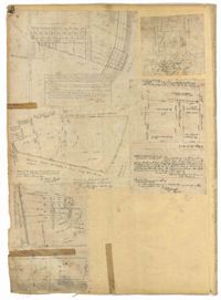
Page 16 of the City Engineer's Plat Book with five plats. Plat 1 shows lots close to the Ashley River located near Tradd Street and Gibbes Street, including a marsh flat labelled as "City Lands." Plat 2 shows lots located near the intersection of Tradd Street and Council Street, including "City marshlands." Plat 3 shows lots located near Gibbes Street and South Bay Street, and includes a dotted line labelled "Low Water Mark." Plat 4 shows land located between Ellery Street and Old Church Street, including a stretch of Raper Street. Plat 5 shows land near the intersection of South Bay Street and "Legare or Johnson Street," and close to the "Low Water" of the Ashley River.
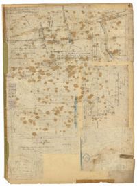
Page 41 of the City Engineer's Plat Book with six plats. Plat 1 shows land between Mount Street and Congress Street, and between a private street and "CITY LANDS Potter's Field." Plat 2 shows lots near Chestnut Street and near Spring Street, Ashton Street, Always Street, Lilly Street, and Pine Street. It also shows a few bodies of water. Plat 3 shows lots near Meeting Street's intersections with Market Alley, and State House Alley. It also labels a court house, the Treasury and Guard House, and St. Michael's Church. Plat 4 shows a stretch of land near President Street, Logan Street, Pinckney Street, Fishburne Street, Mount Street, Congress Street, and shows bodies of water and highlands. Plat 5 shows lots and buildings near the intersection Church Street and Water Street.
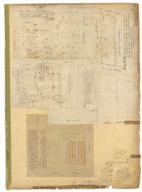
Page 49 of the City Engineer's Plat Book with six plats. Plat 1 shows land on the Cooper River. Plat 2 shows land located near Broad Street's intersections with Gadsden Street and Lynch Street, and a stream labelled "Comings Creek." Plat 3 shows wharfs and buildings along the Cooper River and near Champney Street. Plat 4 shows wharves and other structures between East Bay Street and the Cooper River. Plat 5 shows land near South Bay Street's intersections with Meeting Street and Church Street, including a lot labelled "Battery Garden" and a structure labelled "Bathing House."
Page 19 of the City Engineer's Plat Book with six plats. Plat 1 shows lots and buildings located near the intersection of Pitt Street and Bull Street. Plat 2 shows lots and buildings located near the intersection of Meeting Street and Reid Street. Plat 3 shows lots between King Street and Congress Street, also located near Grove Street and Moultrie Street. Plat 4 shows a lot on Amen Street labelled "Thomas N. Gadsen Esq." and noting multiple brick buildings. Plat 5 shows lots located on Cumberland Street. Plat 6 shows lots located on Amen Street and two two-story brick buildings.
Page 69 of the City Engineer's Plat Book with eight plats. Plat 1 shows land located on either side of Burns Lane, and also shows George Street. Plat 2 features a lot and some buildings on George Street. Plat 3 features lots located on and near King Street, between Beaufain Street and Lynch Street. Plat 4 shows a city block located between Beaufain Street and Wentworth Street, and between Pitt Street and Kirkland Lane. Plat 5 shows lots and some buildings located near the intersection of Smith Street and Montague Street. Plat 6 shows lots on Coming Street, between Montague Street and Wentworth Street. Plat 8 shows lots and some buildings located on Pitt Street, including a lot labelled "The Brown Fellowship Society Cemetery."
Page 51 of the City Engineer's Plat Book with seven plats. Plat 1 shows land located between Tradd Street and the Ashley River, and labels several features of geography such as a patch of marsh and some land labelled "Hard at low water." Plat 1 also shows a lot labelled "City Lands." Plat 2 shows lots and buildings located near the intersection of Tradd Street and Savage Street. Plat 3 shows land located on the west side of New Street. Plat 4 features a lot located at the intersection of New Street and Tradd Street. Plat 5 features lots located near the intersection of New Street and Tradd Street. Plat 6 shows lots located on and near Tradd Street. Plat 7 shows structures located near the intersection of New Street and Broad Street, including a building labelled "Theatre."
Page 54 of the City Engineer's Plat Book with six plats. Plat 1 shows lots located near the intersection of Broad Street and Friend Street. Plat 2 shows land between the Ashley River's low water mark and Smith Street, and between Beaufain Street and Broad Street. It also labels Comings Creek, and an "Edge of High Land." Other Streets on Plat 2 include "Barre Street," Gadsden Street, Beaufain Street, Lynch Street, Queen Street, and Rutledge Street. Plat 3 shows numerous city blocks, "School Land," and a large creek near the Ashley River. Other streets on Plat 3 include Beaufain Street, Wentworth Street, Montague Street, Bull Street, and Pitt Street. Plat 4 shows a similar stretch of land to Plat 3. Plat 5 shows features a lot on Beaufain Street. Plat 6 shows a lot and buildings located near the intersection of King Street and Hutson Street.
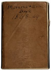
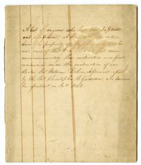
The Robert F.W.Allston Memorandum Book covers the years 1848 and 1849, documenting payments made by Robert Allston, a record of cattle on Waverly, Nightingale Hall and Matanza (later known as Chicora Wood) Plantations and mentions of enslaved people who are referenced by first name. The book also includes loose papers and newspaper clippings on politics, the electoral college and a written statement surrounding the different views over slavery between the northern and southern states.
The Baptism Book for Enslaved People at Walworth and Leamington Plantations, 1848-1853, is a record of enslaved men, women and children who were baptized under officiating ministers Rev. William Dehon and Rev. Christopher D. Gadsden. The book also makes notations regarding enslaved persons who were dead upon receiving baptism. The last two pages are entries about the enslaved persons who underwent the rite of confirmation.