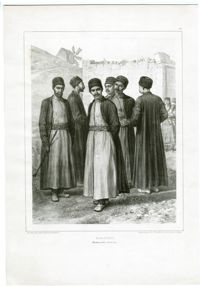
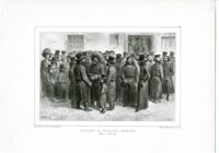
Black-and-white lithograph of Crimean Karaites in Feodosia (Caffa). Lithograph by Denis Auguste Marie Raffet, printed by Auguste Bry. From Voyage dans la Russie Méridionale & la Crimée par la Hongrie, la Valachie et la Moldavie : exécutée en 1837 by Anatoly Nikolaievich Demidov, published Paris: Gihaut Frères.
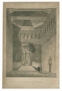
Black-and-white lithograph of interior of the Synagogue of El Transito in Toledo. Drawn by T. J. Rawlins and printed by C. Moody, Litho, 257, Holborn. From The history of the Jews of Spain and Portugal, from the earliest times to their final expulsion from those kingdoms, and their subsequent dispersion by Elias H. Lindo.
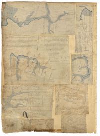
Page 88 of the City Engineer's Plat Book with eight plats. Plat 1 shows a stream and marshland starting at the Ashley River. Plat 2 features land located near the Ashley River and Grove Street. It also features several structures, some marshland, and a creek. Plat 3 shows land located near Grove Street, including some structures, some marshland, and a stream. Plat 4 shows land located Grove Street, including some buildings, a creek, and marshland. Plat 5 shows lots located between a stretch of marsh and Rutledge Avenue. Plat 5 also shows Congress Street, Legare Street, Huger Street, Moultrie Street, and a race track. Plat 6 features Washington Race Course, located between Grove Street and Moultrie Street, and between Congress Street and an unlabeled Street. Plat 7 shows "34 acres of Marsh" located between the Ashley River and a public cemetery. Plat 8 shows marshland located on the Ashley River, near "new Spring Street" and a creek.
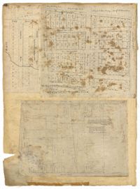
Page 32 of the City Engineer's Plat Book with three plats. Plat 1 shows lots located near the intersection of Tradd Street and Limehouse Street. Plat 2 shows lots located near Elliott Street, Broad Street, and Line Street, near the intersections with Rose Lane, Laurel Street, Percy Street, and Coming Street. Plat 3 shows lots and buildings located between St. Phillip Street and King Street, and Radcliffe Street and Warren Street.
Page 26 of the City Engineer's Plat Book with two plats. Plat 1 is a plan for a public square located near the intersection of Pinkney Street and Boundary Street, and shows a creek. Plat 2 features a lot located on the Ashley River channel and "Commings Creek," located near the intersections of Pinckney Street and Boundary Street, and Bull Street and Rutledge Street. Plat 2 also labels a pond, an island, and "Cannon's Point." Plat 3 shows lots located between Boundary Street and Bull Street, near the intersections with Barre Street, Gadsden Street, Lynch Street, Rutledge Street, Pitt Street, and "Comming Street."
Black-and-white lithograph of Jewish traders and merchants in Odessa. Lithograph by Denis Auguste Marie Raffet, printed by Auguste Bry. From Voyage dans la Russie Méridionale & la Crimée par la Hongrie, la Valachie et la Moldavie : exécutée en 1837 by Anatoly Nikolaievich Demidov, published Paris: Gihaut Frères.
The Charles Manigault Letter Book, 1846-1848 is a bound volume kept by Charles I. Manigault while living in Paris, France with his family between 1846-1848. Letters were sent to James Coward, overseer at Silk Hope Plantation, Thomas Middleton, R. Habersham & Son, Alfred Huger, Anthony Barclay, Y. Haynes, overseer at Gowrie Plantation, Louis Manigault and Charles Manigault Jr. Topics of conversation found in these letters include business operations at the plantations, enslaved people's resistance via running away, treatment and punishment of slaves, a group of slaves taking an overseer to court, living abroad in Paris, Charles Manigault's views on racial equality in Paris, the Manigault children's schooling in Paris and at Yale College, traveling Europe, meeting Muhammad Ali, the leader of Egypt and discussing the Mexican American War and Egyptian politics, Charles Manigault's Huguenot ancestry and history, and being in Paris during the French Revolution of 1848.
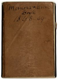
The Robert F.W.Allston Memorandum Book covers the years 1848 and 1849, documenting payments made by Robert Allston, a record of cattle on Waverly, Nightingale Hall and Matanza (later known as Chicora Wood) Plantations and mentions of enslaved people who are referenced by first name. The book also includes loose papers and newspaper clippings on politics, the electoral college and a written statement surrounding the different views over slavery between the northern and southern states.
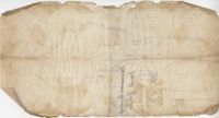
Plat of 1126 acres in St. James Goose Creek on Wasamasaw [Wassamassaw] Swamp. Plat is in pencil and is difficult to read the few details, although there are a few outlines of buildings included, but difficult to tell what they are. Names associated with this plat include Daniel Gelyer, J. Ferrels, Thomas Cusack [?], and James Haney. Notable geographic locations include Wasamasaw [Wassamassaw] Swamp, Sheep Island, Goose Creek, Road to Dorchester, and Ekells Branch.
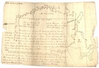
Copy of two tracts of land A and B. A containing 1144 acres, and B, containing 580 located north of the Santee River and Duck Creek for Georgetown District. John Hutchinson, Chardon, Laroche, Foijsin, Gail Huger, Isaac Huger, Mark Hugin, Ford, Job. Rothmaklen, Jospeh Purcell and Charles Parker. Notable geographic locations include Mosquito Creek, Four Mile Creek, Belin Creek Duck Creek, Minim Creek, Santee River, Winyaw Bay, and Georgetown District.