Silent film footage of Mr. and Mrs. Clarence E. Chapman at Mulberry Castle a/k/a Mulberry Plantation, ca. 1927-1932. Includes scenes of the Chapmans, their guests, and their laborers. Features vistas of the main house, grounds, and river; scenes of duck and deer hunting, picnicking, fishing, boating, and horseback riding.
Historic Charleston Foundation's, "An Architectural Guide to Charleston, South Carolina, 1700-1900,' written in manuscript form by Albert Simons, F. A. I. A., and W. H. Johnson, compiled by Historic Charleston Foundation, discussing structures from the Colonial Period (1700-1775), Post Revolutionary Period (1782-1820), Ante-Bellum Period (1820-1860), and Post Civil War Period (1865-1900).
A twelve-part publication about Charleston, South Carolina and the surrounding region. The twelve volumes are mostly composed of black and white photographs and also contain text that runs contiguously throughout. The volumes contain images of well-known homes, monuments, gardens, cemeteries, and buildings, along with notable industrial sites.
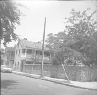
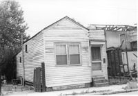
House-like structure in dilapidated condition (side view) on site affected by the construction of Interstate 26 (I-26). Dirt lot in foreground. Address: 739 Meeting Street. Surveyor notations on back of photo: "Dkt.: 10.503. Property owner: Eula Chitwood. Tract: 61. Station: 5909+30 Rt. Date: Feb. 20, 1963. In R/W - Bought." [See collection description for explanation of surveyor notations.]
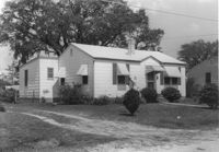
House on site affected by the construction of Interstate 26 (I-26). Building address number 197. Garage/shed at end of driveway. Surveyor notations on back of photo: "Dkt.: 10.480. Property owner: Geo. Smith, et al. Tract: 135. Station: 5654+50 Rt. Date: May 2, 1961. In R/W - Bought." [See collection description for explanation of surveyor notations.]
House on site affected by the construction of Interstate 26 (I-26). Building address number 189. Garage/shed at end of driveway. Surveyor notations on back of photo: "Dkt.: 10.480. Property owner: Elmer C. Waite. Tract: 131. Station: 5652+30 Rt. Date: May 2, 1961. In R/W - Bought." [See collection description for explanation of surveyor notations.]
House-like structure on site affected by the construction of Interstate 26 (I-26). Address: 739 Meeting Street. Surveyor notations on back of photo: "Dkt.: 10.503. Property owner: George E. Williams. Tract: 60. Station: 5909+30 Rt. Date: Feb. 20, 1963. In R/W - Bought." [See collection description for explanation of surveyor notations.]
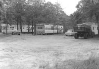
Trailers (trailer park?) on site affected by the construction of Interstate 26 (I-26). Surveyor notations on back of photo: "Dkt.: 10.480. Property owner: Williams Furniture Co., et al. Tract: 103-E. Station: 5580+80 Rt. (Line J). Date: May 2, 1961. Loss underground improvements." [See collection description for explanation of surveyor notations.]
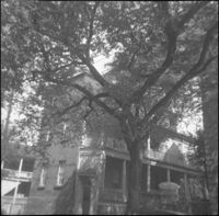
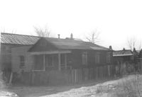
House (freedman's cottage) on site affected by the construction of Interstate 26 (I-26). Address: 23 Riker Street. Surveyor notations on back of photo: "Dkt.: 10.503. Property owner: Lucille Williams. Tract: 68. Station: 5911+40 Rt. Date: May 30, 1963. In R/W - Bought." [See collection description for explanation of surveyor notations.]
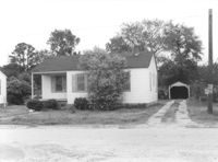
House (corner view) on site affected by the construction of Interstate 26 (I-26). Garage/shed at end of driveway. Surveyor notations on back of photo: "Dkt.: 10.480. Property owner: R.R. Barwick. Tract: 137. Station: 5655+80 Rt. Date: May 2, 1961. In R/W - Bought." [See collection description for explanation of surveyor notations.]
House on site affected by the construction of Interstate 26 (I-26). Address: 11 Brigade Street. Surveyor notations on back of photo: "Dkt.: 10.503. Property owner: Ada Williams. Tract: 42. Station: 5905+20 Rt. Date: Feb. 19, 1963. In R/W - Bought." [See collection description for explanation of surveyor notations.]
Row of houses on site affected by the construction of Interstate 26 (I-26). Address: 20-32 Brigade Street. Surveyor notations on back of photo: "Dkt.: 10.503. Property owner: Gussie Feldman. Tract: 41. Station: 5904+30 Rt. In R/W - Bought." [See collection description for explanation of surveyor notations.]
Building (corner view, front) on site affected by the construction of the Crosstown. Address: 120 Drake Street (based on buildings across the street). Sign in front: Harrisson & Co. Fishing Tacking Hardware. Elevated roadway (presumably the off-ramp of the Grace Memorial Bridge) in background. Surveyor notations on back of photo: "Dkt.: 10.518. Property owner: Frank J. Kelly. Tract: 78. Station: 55+60 Rt. N.B. lane Route 17. Date: Mar. 7, 1963." [See collection description for explanation of surveyor notations.]
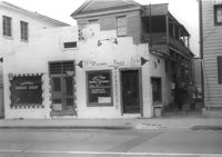
Building, on site affected by the construction of the Crosstown. Address: 209 Spring Street. Friendly Barber Shop and Spot Light Radio TV Service. Front facade has stepped parapet. Surveyor notations on back of photo: "Dkt.: 10.524. Property owner: Maybell Fields. Tract: 166. Station: 20+00 Rt. Spring Street. Date: Dec. 2, 1964." [See collection description for explanation of surveyor notations.]