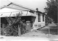
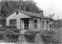
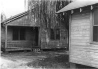
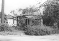
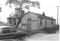
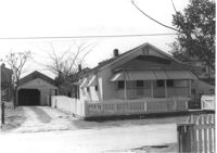
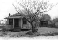
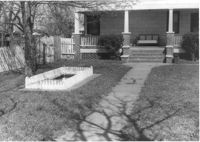
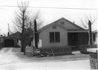
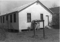
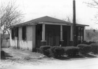
House and fence to driveway next to market (see I-26 Photo 1159), on site affected by the construction of Interstate 26 (I-26). Surveyor notations on back of photo: "Dkt.: 10.490. Property owner: Loretta Gaillard [Loretta Gillard]. Tract: 56. 5800+00 Lt. Line 'G'. Date: September 12, 1962. In R/W - Bought." [See collection description for explanation of surveyor notations.]
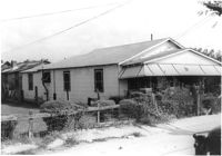
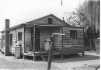
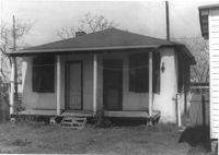
House (see I-26 Photos 1159-1160) and side lot/yard, on site affected by the construction of Interstate 26 (I-26). Surveyor notations on back of photo: "Dkt.: 10.490. Property owner: Loretta Gaillard [Loretta Gillard]. Tract: 56. 5801+80 on CL Line 'F'. Date: September 12, 1962. In R/W - Bought." [See collection description for explanation of surveyor notations.]
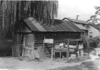
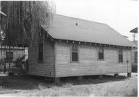
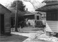
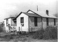
House and garage or shed on site affected by the construction of Interstate 26 (I-26). Surveyor notations on back of photo: "Dkt.: 10.490. Property owner: Loretta Gillard [Loretta Gaillard]. Tract: 56. 5800+00 Lt. Line 'G'. Date: September 12, 1962. In R/W - Bought." [See collection description for explanation of surveyor notations.]
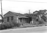
Garage or shed on site affected by the construction of Interstate 26 (I-26). Surveyor notations on back of photo: "Dkt.: 10.490. Property owner: Loretta Gillard [Loretta Gaillard]. Tract: 56. 5799+90 Lt. Line 'G'. Date: September 12, 1962. In R/W - Bought." [See collection description for explanation of surveyor notations.]
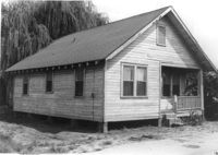
House (rear view) on site affected by the construction of Interstate 26 (I-26). Surveyor notations on back of photo: "Dkt.: 10.490. Property owner: Loretta Gillard [Loretta Gaillard]. Tract: 56. 5801+50 Lt. Line 'F'. Date: September 12, 1962. In R/W - Bought." [See collection description for explanation of surveyor notations.]
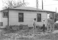
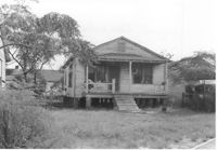
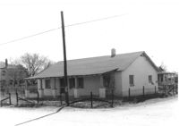
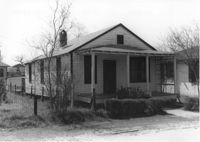
House on site affected by the construction of Interstate 26 (I-26). Surveyor notations on back of photo: "Dkt.: 10.490. Property owner: Leah D. Governor. Tract: 58. Station: 5800+70 Lt. Line 'G'. Date: September 12, 1962. In R/W - Bought." [See collection description for explanation of surveyor notations.]
House (rear view) on site affected by the construction of Interstate 26 (I-26). Surveyor notations on back of photo: "Dkt.: 10.490. Property owner: Leah D. Governor. Tract: 58. Station: 5800+70 Lt. Line 'G'. Date: September 12, 1962. In R/W - Bought." [See collection description for explanation of surveyor notations.]
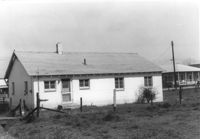
Shed on site affected by the construction of Interstate 26 (I-26). Surveyor notations on back of photo: "Dkt.: 10.490. Property owner: Leah D. Governor. Tract: 58. Station: 5800+60 Rt. Line 'G'. Date: September 12, 1962. In R/W - Bought." [See collection description for explanation of surveyor notations.]
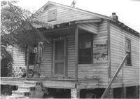
House on site affected by the construction of Interstate 26 (I-26). Surveyor notations on back of photo: "Dkt.: 10.490. Property owner: E.S. Lapine, et al. Tract: 59. Station: 5801+15 on CL Line 'G'. Date: September 12, 1962. In R/W - Bought." [See collection description for explanation of surveyor notations.]
House on site affected by the construction of Interstate 26 (I-26). Surveyor notations on back of photo: "Dkt.: 10.490. Property owner: E.S. Lapine, et al. Tract: 59. Station: 5800+75 Rt. Line 'G'. Date: September 12, 1962. In R/W - Bought." [See collection description for explanation of surveyor notations.]
House (rear view) on site affected by the construction of Interstate 26 (I-26). Surveyor notations on back of photo: "Dkt.: 10.490. Property owner: E.S. Lapine, et al. Tract: 59. Station: 5801+15 on CL Line 'G'. Date: September 12, 1962. In R/W - Bought." [See collection description for explanation of surveyor notations.]
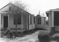
House and structures on site affected by the construction of Interstate 26 (I-26). Surveyor notations on back of photo: "Dkt.: 10.490. Property owner: E.S. Lapine, et al. Tract: 59. Station: 5800+80 Rt. Line 'G'. Date: September 12, 1962. In R/W - Bought." [See collection description for explanation of surveyor notations.]
House (rear view) on site affected by the construction of Interstate 26 (I-26). Surveyor notations on back of photo: "Dkt.: 10.490. Property owner: E.S. Lapine, et al. Tract: 60. Station: 5801+40 Rt. Line 'G'. Date: September 12, 1962. In R/W - Bought." [See collection description for explanation of surveyor notations.]
House on site affected by the construction of Interstate 26 (I-26). Surveyor notations on back of photo: "Dkt.: 10.490. Property owner: E.S. Lapine, et al. Tract: 60. Station: 5801+40 Rt. Line 'G'. Date: September 12, 1962. In R/W - Bought." [See collection description for explanation of surveyor notations.]
House (side view) on site affected by the construction of Interstate 26 (I-26). Surveyor notations on back of photo: "Dkt.: 10.490. Property owner: E.S. Lapine, et al. Tract: 60. Station: 5801+40 Rt. Line 'G'. Date: September 12, 1962. In R/W - Bought." [See collection description for explanation of surveyor notations.]
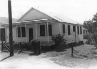
House (rear view) on site affected by the construction of Interstate 26 (I-26). Surveyor notations on back of photo: "Dkt.: 10.490. Property owner: F.F. Bellinger, et al. Tract: 61. Station: 5801+20 Rt. Line 'G'. Date: September 12, 1962. Proximity." [See collection description for explanation of surveyor notations.]
House on site affected by the construction of Interstate 26 (I-26). Surveyor notations on back of photo: "Dkt.: 10.490. Property owner: John Nesbitt. Tract: 63. Station: 5802+00 Lt. Line 'F'. Date: September 12, 1962. In R/W - Bought." [See collection description for explanation of surveyor notations.]
House (rear view) on site affected by the construction of Interstate 26 (I-26). Surveyor notations on back of photo: "Dkt.: 10.490. Property owner: John Nesbitt. Tract: 63. Station: 5802+00 Lt. Line 'F'. Date: September 12, 1962. In R/W - Bought." [See collection description for explanation of surveyor notations.]
House (rear view) on site affected by the construction of Interstate 26 (I-26). Surveyor notations on back of photo: "Dkt.: 10.490. Property owner: Cora L. Gantt, et al. Tract: 64. Station: 5802+80 Lt. Line 'F'. Date: September 12, 1962. In R/W - Bought." [See collection description for explanation of surveyor notations.]
House on site affected by the construction of Interstate 26 (I-26). Surveyor notations on back of photo: "Dkt.: 10.490. Property owner: Cora L. Gantt, et al. Tract: 64. Station: 5802+80 Lt. Line 'F'. Date: September 12, 1962. In R/W - Bought." [See collection description for explanation of surveyor notations.]
House on site affected by the construction of Interstate 26 (I-26). Building address number 208. Surveyor notations on back of photo: "Dkt.: 10.490. Property owner: Cora L. Gantt, et al. Tract: 65. Station: 5802+90 Lt. Line 'F'. Date: September 12, 1962. In R/W - Bought." [See collection description for explanation of surveyor notations.]
House (rear view) on site affected by the construction of Interstate 26 (I-26). [Building address number 208.] Surveyor notations on back of photo: "Dkt.: 10.490. Property owner: Cora L. Gantt, et al. Tract: 65. Station: 5802+90 Lt. Line 'F'. Date: September 12, 1962. In R/W - Bought." [See collection description for explanation of surveyor notations.]
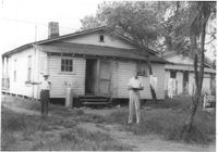
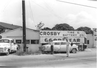
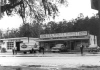
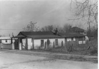
Crosby Tire & Battery Co., on site affected by the construction of Interstate 26 (I-26). [Address 2204 or 2206 Meeting Street Road.] Surveyor notations on back of photo: "Dkt.: 10.490. Property owner: M. Crosby. Tract: 66. Station: 5803+30 Lt. Line 'F'. Date: September 12, 1962. To be cut at R/W." [See collection description for explanation of surveyor notations.]
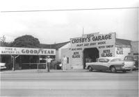
Crosby Tire & Battery Co. and Crosby's Garage, on site affected by the construction of Interstate 26 (I-26). Address 2204 and 2206 [Meeting Street Road]. Surveyor notations on back of photo: "Dkt.: 10.490. Property owner: M. Crosby. Tract: 66. Station: 5803+40 Lt. Line 'F'. Date: September 12, 1962. Proximity." [See collection description for explanation of surveyor notations.]
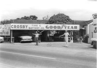
Crosby Tire & Battery Co., on site affected by the construction of Interstate 26 (I-26). [Address 2204 or 2206 Meeting Street Road.] Surveyor notations on back of photo: "Dkt.: 10.490. Property owner: M. Crosby. Tract: 66. Station: 5803+30 Lt. Line 'F'. Date: September 12, 1962. To be cut at R/W." [See collection description for explanation of surveyor notations.]
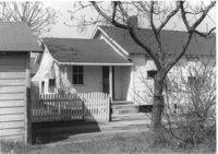
House and yard on site affected by the construction of Interstate 26 (I-26). Surveyor notations on back of photo: "Dkt.: 10.490. Property owner: Carole Morrison. Tract: 70. Date: March 22, 1962. House moved by owner." [See collection description for explanation of surveyor notations.]
House on site affected by the construction of Interstate 26 (I-26). Building address number 2205 [2205 Peace]. Garage at end of driveway. Surveyor notations on back of photo: "Dkt.: 10.490. Property owner: W.W. Tuten. Tract: 73. Station: 5821+90 Lt. Date: March 22, 1962. In R/W - Bought." [See collection description for explanation of surveyor notations.]
House (rear view) on site affected by the construction of Interstate 26 (I-26). [Building address number 2205 (2205 Peace).] Surveyor notations on back of photo: "Dkt.: 10.490. Property owner: W.W. Tuten. Tract: 73. Station: 5821+90 Lt. Date: March 22, 1962. In R/W - Bought." [See collection description for explanation of surveyor notations.]
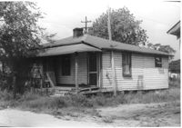
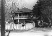
House on site affected by the construction of Interstate 26 (I-26). [Address 2207 Peace.] View of street corner. Surveyor notations on back of photo: "Dkt.: 10.490. Property owner: Carl W. Huckabee. Tract: 76. Station: 5820+45 Rt. Line 'G'. Date: March 22, 1962. In R/W - Bought." [See collection description for explanation of surveyor notations.]
House (rear view) on site affected by the construction of Interstate 26 (I-26). [Address 2207 Peace.] Surveyor notations on back of photo: "Dkt.: 10.490. Property owner: Carl W. Huckabee. Tract: 76. Station: 5820+45 Rt. Line 'G'. Date: March 22, 1962. In R/W - Bought." [See collection description for explanation of surveyor notations.]
House on site affected by the construction of Interstate 26 (I-26). [Address 2208 Delano.] Surveyor notations on back of photo: "Dkt.: 10.490. Property owner: O.D. Tanner. Tract: 77. Station: 5822+32 Rt. Line 'G'. Date: March 22, 1962. In R/W - Bought." [See collection description for explanation of surveyor notations.]
House (rear view) and lot on site affected by the construction of Interstate 26 (I-26). [Address 2208 Delano.] Surveyor notations on back of photo: "Dkt.: 10.490. Property owner: O.D. Tanner. Tract: 77. Station: 5822+32 Rt. Line 'G'. Date: March 22, 1962. In R/W - Bought." [See collection description for explanation of surveyor notations.]
House on site affected by the construction of Interstate 26 (I-26). [Address 2208 Delano.] Surveyor notations on back of photo: "Dkt.: 10.490. Property owner: Geo. F. Garner [George F. Garner]. Tract: 78. Station: 5822+50 Lt. Date: March 22, 1962. In R/W - Bought." [See collection description for explanation of surveyor notations.]
House (rear view), shed, lot, and fence, on site affected by the construction of Interstate 26 (I-26). [Address 2208 Delano.] Surveyor notations on back of photo: "Dkt.: 10.490. Property owner: Geo. F. Garner [George F. Garner]. Tract: 78. Station: 5822+50 Lt. Date: March 22, 1962. In R/W - Bought." [See collection description for explanation of surveyor notations.]
House and front yard on site affected by the construction of Interstate 26 (I-26). [Address 2208 Delano.] Surveyor notations on back of photo: "Dkt.: 10.490. Property owner: Geo. F. Garner [George F. Garner]. Tract: 78. Station: 5822+50 Lt. Date: March 22, 1962. In R/W - Bought." [See collection description for explanation of surveyor notations.]
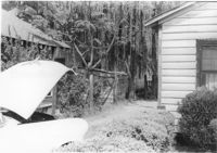
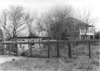
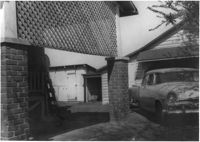
View through brick columns of shed and neighboring house, on site affected by the construction of Interstate 26 (I-26). [Address 2208 Delano.] Surveyor notations on back of photo: "Dkt.: 10.490. Property owner: Geo. F. Garner [George F. Garner]. Tract: 78. Station: 5822+40-5822+80 Rt. Date: March 22, 1962. In R/W - Bought." [See collection description for explanation of surveyor notations.]
House on site affected by the construction of Interstate 26 (I-26). Building address number ____ [____ Delano]. Surveyor notations on back of photo: "Dkt.: 10.490. Property owner: Ruth Mattox. Tract: 79. Station: 5823+00 Lt. Date: March 22, 1962. In R/W - Bought." [See collection description for explanation of surveyor notations.]
House (rear view) on site affected by the construction of Interstate 26 (I-26). [Building address number ____. ____ Delano.] Surveyor notations on back of photo: "Dkt.: 10.490. Property owner: Ruth Mattox. Tract: 79. Station: 5823+00 Lt. Date: March 22, 1962. In R/W - Bought." [See collection description for explanation of surveyor notations.]
House on site affected by the construction of Interstate 26 (I-26). Garage at end of driveway. [Address 2207 Delano.] Surveyor notations on back of photo: "Dkt.: 10.490. Property owner: Harry G. Cusack. Tract: 80. Station: 5824+15 Lt. Date: March 22, 1962. In R/W - Bought." [See collection description for explanation of surveyor notations.]
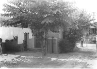
Structures and backyard behind house on site affected by the construction of Interstate 26 (I-26). [Address 2207 Delano.] Surveyor notations on back of photo: "Dkt.: 10.490. Property owner: Harry G. Cusack. Tract: 80. Station: 5824+15 Lt. Date: March 22, 1962. In R/W - Bought." [See collection description for explanation of surveyor notations.]
J&K Minute Market [893 Folly Road] and Sinclair gas station, on site affected by the widening of Route 171 (Folly Road). Surveyor notations on back of photo: "Dkt.: 10.494. Property owner: Otis R. Burbage. Tract: 40. Station: 176+40 Rt. Date: Mar. 21, 1962. Proximity. [See collection description for explanation of surveyor notations.]
House on site affected by the construction of Interstate 26 (I-26). Building address number 2209. [2209 Delano.] Surveyor notations on back of photo: "Dkt.: 10.490. Property owner: Dantzler H. Gardner, Est. Tract: 81. Station: 5824+00 Lt. Date: March 22, 1962. In R/W - Bought." [See collection description for explanation of surveyor notations.]
House (rear view) on site affected by the construction of Interstate 26 (I-26). [Building address number 2209. 2209 Delano.] Surveyor notations on back of photo: "Dkt.: 10.490. Property owner: Dantzler H. Gardner, Est. Tract: 81. Station: 5824+00 Lt. Date: March 22, 1962. In R/W - Bought." [See collection description for explanation of surveyor notations.]
House on site affected by the construction of Interstate 26 (I-26). [Address 2213 Delano.] Surveyor notations on back of photo: "Dkt.: 10.490. Property owner: Cath. Mason Lewis. Tract: 83. Station: 5824+00 on CL. Date: March 22, 1962. In R/W - Bought." [See collection description for explanation of surveyor notations.]
House (rear view) on site affected by the construction of Interstate 26 (I-26). [Address 2213 Delano.] Surveyor notations on back of photo: "Dkt.: 10.490. Property owner: Cath. Mason Lewis. Tract: 83. Station: 5824+00 on CL. Date: March 22, 1962. In R/W - Bought." [See collection description for explanation of surveyor notations.]
House on site affected by the construction of Interstate 26 (I-26). [Address 2213 Delano.] Surveyor notations on back of photo: "Dkt.: 10.490. Property owner: Cath. Mason Lewis. Tract: 83. Station: 5824+00 on CL. Date: March 22, 1962. In R/W - Bought." [See collection description for explanation of surveyor notations.]
House on site affected by the construction of Interstate 26 (I-26). Building address number 2215. [2215 Delano.] Surveyor notations on back of photo: "Dkt.: 10.490. Property owner: Cath. Mason Lewis. Tract: 84. Station: 5824+00 Rt. Date: March 22, 1962. In R/W - Bought." [See collection description for explanation of surveyor notations.]
House (rear view) on site affected by the construction of Interstate 26 (I-26). [Building address number 2215. 2215 Delano.] Surveyor notations on back of photo: "Dkt.: 10.490. Property owner: Cath. Mason Lewis. Tract: 84. Station: 5824+00 Rt. Date: March 22, 1962. In R/W - Bought." [See collection description for explanation of surveyor notations.]
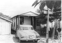
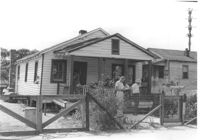
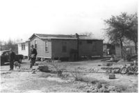
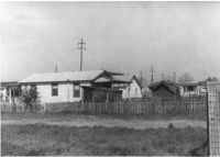
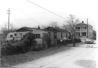
House, trailer, and street on site affected by the construction of Interstate 26 (I-26). Surveyor notations on back of photo: "Dkt.: 10.490. Property owner: Jacob Myers, et al. Tract: 86-A. Station: 5823+90 Rt. Date: March 22, 1962. Proximity to house. Owner to move trailer." [See collection description for explanation of surveyor notations.]
House on site affected by the construction of Interstate 26 (I-26). Surveyor notations on back of photo: "Dkt.: 10.490. Property owner: Jacob Myers, et al. Tract: 86-A. Station: 5823+90 Rt. Date: March 22, 1962. Proximity to house." [See collection description for explanation of surveyor notations.]