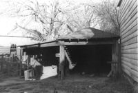
Garage and shed on site affected by the construction of the Crosstown. Address: 504 Rutledge Avenue. Surveyor notations on back of photo: "Dkt.: 10.524. Property owner: Florence Britton Jones. Tract: 114. Station: 87±00 Rt. Date: Dec. 1, 1964. In R/W - Bought." [See collection description for explanation of surveyor notations.]
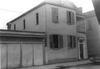
House on site affected by the construction of the Crosstown. Address: 161A Line Street [161 Line Street]. Portion of neighboring structure (garage?) in picture; see US Route 17 Photo 378. Surveyor notations on back of photo: "Dkt.: 10.524. Property owner: Marie Suares. Tract: 97. Station: 82+75 Rt. Date: Dec. 1, 1964. In R/W - Bought." [See collection description for explanation of surveyor notations.]
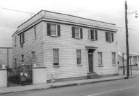
House on site affected by the construction of the Crosstown. Address: 215 Spring Street. Corner of Spring Street and Vaughan Street. Surveyor notations on back of photo: "Dkt.: 10.524. Property owner: Ruby E. Jacobs. Tract: 163. Station: 18+85 Rt. Spring Street. Date: Dec. 2, 1964. Partially In R/W - Bought." [See collection description for explanation of surveyor notations.]
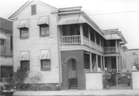
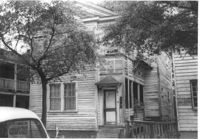
House on site affected by the construction of the Crosstown. Address: 213 Spring Street. Surveyor notations on back of photo: "Dkt.: 10.524. Property owner: Loretta Jackson. Tract: 164. Station: 19+30 Rt. Spring Street. Date: Dec. 2, 1964. Condemned." [See collection description for explanation of surveyor notations.]
House on site affected by the construction of the Crosstown. Address: 213 Spring Street. Surveyor notations on back of photo: "Dkt.: 10.524. Property owner: Loretta Jackson. Tract: 164. Station: 19+30 Rt. Spring Street. Date: Dec. 2, 1964. Condemned." [See collection description for explanation of surveyor notations.]
Lot with billboards for 1965 Corvair (Fort Sumter Chevrolet Co.) and Falstaff (beer), on site affected by the construction of the Crosstown. Address: 223 Spring Street. Surveyor notations on back of photo: "Dkt.: 10.524. Property owner: Turner Advertising Co. Tract: 159. Station: 16±80 Rt. Date: Dec. 2, 1964." [See collection description for explanation of surveyor notations.]
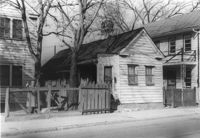
House (freedman's cottage) on site affected by the construction of the Crosstown. Address: 162½ Line Street [162 Line Street]. Surveyor notations on back of photo: "Dkt.: 10.524. Property owner: Frederick J. Cook. Tract: 99. Station: 82+65 Lt. Date: Dec. 1, 1964. In R/W - Bought." [See collection description for explanation of surveyor notations.]
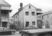
House on site affected by the construction of the Crosstown. Address: 265 Ashley Avenue. Surveyor notations on back of photo: "Dkt.: 10.524. Property owner: William A. Dart, et al. Tract: 80. Station: 78+90 CL Rt. Date: Oct. 14, 1964. In R/W - Bought." [See collection description for explanation of surveyor notations.]
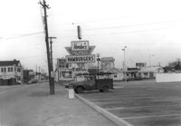
View on Spring Street from the Hardee's parking lot, on site affected by the construction of the Crosstown. Address: 223 Spring Street. Sea Food Dining Room in background, and signage for Hardee's and Everett's Hotel and Patio [restaurant?]. Surveyor notations on back of photo: "Dkt.: 10.524. Property owner: Sarah Chinnis Sanders. Tract: 157. Station: 13+75 Rt. Spring Street. Date: Dec. 2, 1964." [See collection description for explanation of surveyor notations.]
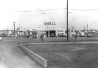
Shell gas station, on site affected by the construction of the Crosstown. Address: 233 Spring Street. View of street corner. Surveyor notations on back of photo: "Dkt.: 10.524. Property owner: Shell Oil Co. Tract: 155. Station: 9+00 Rt. Spring Street. Date: Dec. 2, 1965. Panoramic view." [See collection description for explanation of surveyor notations.]