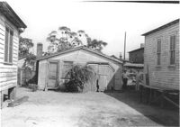
Shed or garage associated with Francis Brown Methodist Church, on site affected by the construction of Interstate 26 (I-26). [2202 Joppa.] Surveyor notations on back of photo: "Dkt.: 10.490. Property owner: Francis Brown Meth. Church. Tract: 52. Station: 5799+80 Lt. Line 'F'. Date: September 12, 1962. To be cut off at R/W by SCHD [SC Highway Department]." [See collection description for explanation of surveyor notations.]
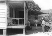
House (rear view) associated with Francis Brown Methodist Church, on site affected by the construction of Interstate 26 (I-26). Surveyor notations on back of photo: "Dkt.: 10.490. Property owner: Francis Brown Meth. Church. Tract: 52. Station: 5800+20 Lt. Line 'F'. Date: September 12, 1962. Proximity to rear." [See collection description for explanation of surveyor notations.]
House associated with Francis Brown Methodist Church, on site affected by the construction of Interstate 26 (I-26). Surveyor notations on back of photo: "Dkt.: 10.490. Property owner: Francis Brown Meth. Church. Tract: 52. Station: 5800+20 Lt. Line 'F'. Date: September 12, 1962. Proximity to rear." [See collection description for explanation of surveyor notations.]
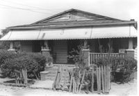
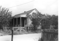
House on site affected by the construction of Interstate 26 (I-26). Surveyor notations on back of photo: "Dkt.: 10.490. Property owner: Barney Witherspoon, et al. Tract: 53. Station: 5800+40 on CL Line 'F'. Date: September 12, 1962. In R/W - Bought." [See collection description for explanation of surveyor notations.]
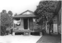
House on site affected by the construction of Interstate 26 (I-26). Surveyor notations on back of photo: "Dkt.: 10.490. Property owner: William Parineau, et al. Tract: 54. Station: 5800+80 Lt. Line 'F'. Date: September 12, 1962. In R/W - Bought." [See collection description for explanation of surveyor notations.]
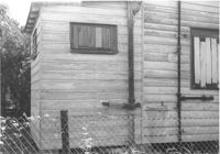
Exterior wall of house on site affected by the construction of Interstate 26 (I-26). Surveyor notations on back of photo: "Dkt.: 10.490. Property owner: William Parineau, et al. Tract: 54. Station: 5800+80 Lt. Line 'F'. Date: September 12, 1962. In R/W - Bought." [See collection description for explanation of surveyor notations.]
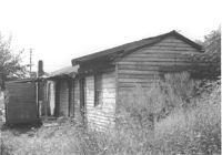
House (rear view) on site affected by the construction of Interstate 26 (I-26). Surveyor notations on back of photo: "Dkt.: 10.490. Property owner: George L. Haseldor. Tract: 55. Station: 5801+15 Lt. Line 'F'. Date: September 12, 1962. In R/W - Bought." [See collection description for explanation of surveyor notations.]
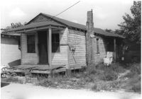
House on site affected by the construction of Interstate 26 (I-26). Surveyor notations on back of photo: "Dkt.: 10.490. Property owner: George L. Haseldor. Tract: 55. Station: 5801+15 Lt. Line 'F'. Date: September 12, 1962. In R/W - Bought." [See collection description for explanation of surveyor notations.]
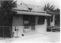
Building on site affected by the construction of Interstate 26 (I-26). Appears to previously have been a market; signage for Tru Ade (Drink) in window; gumball machines in front on sidewalk. Front facade has stepped parapet. Surveyor notations on back of photo: "Dkt.: 10.490. Property owner: Loretta Gillard [Loretta Gaillard]. Tract: 56. 5801+55 Lt. Line 'F'. Date: September 12, 1962. In R/W - Bought." [See collection description for explanation of surveyor notations.]
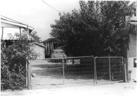
Fence to driveway next to market (see I-26 Photo 1158), on site affected by the construction of Interstate 26 (I-26). View of structures at end of driveway and partial view of neighboring house. Surveyor notations on back of photo: "Dkt.: 10.490. Property owner: Loretta Gaillard [Loretta Gillard]. Tract: 56. 5799+80 Lt. Line 'G'. Date: September 12, 1962. In R/W - Bought." [See collection description for explanation of surveyor notations.]