Receipt book belonging to Mary Motte Alston Pringle containing recipes, methods and remedies for food, housekeeping, and medicine from family, friends, articles and world travelers. Pringle often notes on effectiveness and provides personal anecdotes. Pages numbered 74 through 97 in Pringle's book are blank and therefore omitted. The table of contents can be found at the end of the book.
Receipt book of Mrs. William Timmons (likely Isabella Darrell Timmons, 1771-1843) containing recipes for cakes, medicinal remedies, puddings, household cleaners, animal and bug repellents, cocktails, and wines among other things.
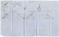
The Horlbeck Cash and Estimate Book, 1839-1849, was kept by members of the Horlbeck building and architectural business. The first half of the book is a cash book listing expenses and income. Expenses were for laborers described as white and "negroe", lime, bricks and "negro cloth." The second half of the book lists projected costs, lists of supplies, descriptions and occasional floor plans and drawings for structures to be built, repaired, and remodeled. Buildings include a dwelling house for a "Colored Man" and an Engine House.
The Horlbeck Daybook, 1835-1837, was kept by members of the Horlbeck building and architectural business. Included in the daybook are lists of work done for clients such as remodeling, repair, or construction. Buildings worked on include the jail, St. Stephen's Chapel, the Fire Master's Department, and the Poor House. The descriptions include types of materials used and the number of Black and White employees working. Black employees consist of enslaved and freed persons.
Frean cannot communicate with Major J.A. Leland regarding what Drayton is owed; he relates his good wishes regarding Drayton's forthcoming marriage to Louisa Elford.
The Horlbeck Ledger, 1839-1847, is a bound volume by members of the Horlbeck building and architectural business. The book records work done for clients White and Black employees and specifies the type of repair, remodeling or construction jobs and supplies. Black employees are comprised of enslaved persons and freed men and women.
Frean offers his condolences concerning the death of Charles Drayton, James' father; discusses his work as a surveyor and James' prospects for employment
The Paul De St. Julien Ravenel Estate Book, 1829-1841 is an estate account book kept by Henry Ravenel for the estate of Paul D. Ravenel with pages on money received, spent or payments paid, including payments for the hiring of enslaved people. The last few pages of the book are lists of slaves, referenced by first name, and the number of sheets given out.
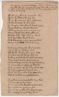
Handwritten poem by James Drayton about a conversation held in a prison between a father and his daughter during the reign of the English King Richard III
The Roslin Plantation journal, kept by Archibald Simpson Johnston, documented enslaved people and slave labor on an antebellum plantation for two years (1813-1815). The journal documents correspondence, equipment, planting and harvesting, livestock, slaves and supplies related to the plantation. There are detailed descriptions of tasks and number of enslaved people working each task, particularly tasks regarding growing cotton and rice and maintainining those fields.
A cash book for Robert F.W. Allston for the years 1823-1843. The book includes account transactions conducted by Allston including payment of overseer wages, the hiring out of enslaved people, transportation, taxes, governesses, nurses, crops, sundries, and cloth distributed to slaves. This book also includes accounts between Allston and other individuals including the Estate of Charlotte A. Allston (primarily for the purchases of blankets, shoes, and cloth for enslaved people) and an account with Mary P. Jones. The last several pages of the book contain cash ledgers. Allston explicitly notes accounting related to Matanza Plantation, later known as Chicora Wood. Other account records do not explicitly state plantation sites.
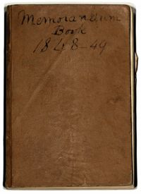
The Robert F.W.Allston Memorandum Book covers the years 1848 and 1849, documenting payments made by Robert Allston, a record of cattle on Waverly, Nightingale Hall and Matanza (later known as Chicora Wood) Plantations and mentions of enslaved people who are referenced by first name. The book also includes loose papers and newspaper clippings on politics, the electoral college and a written statement surrounding the different views over slavery between the northern and southern states.
Notes on Charles Sumner's Lecture on White Slavery in the Barbary States, 1847, is a bound journal kept by a member of the Allston family in which they summarize the lecture given by Charles Sumner at the Boston Mercantile Library Association. The lecture discusses the Missouri Compromise, the "peculiar institution of the south," the history of slavery by the nations of antiquity, the importation of enslaved people into the English world, a timeline of slavery in the United States and Sumner's opinions of slavery as being cruel and sinful.
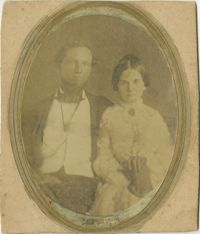
Black-and-white photograph, on card, of a bride and groom. Writing on back of card reads, "Bride and Groom. Dr. and Mrs. W.D. Ellis about 1840. Parents of: Judge W.D. Ellis, Atlanta; Mrs. W.W. McLeod; Miss Rose M. Ellis; Mrs. John P. Fort; Dr. D.W. Ellis."
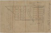
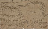
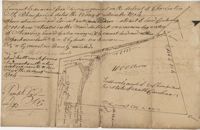
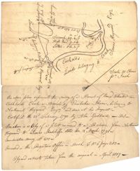
Copy of a plan of lots No.1-7, 9-11 on Cumberland Street in Charleston, Ward No.3. Indicates some buildings including a brick stable at No. 9 and DeBorr’s house and lot. “Lands of Mr. Edwards" is written above the lots. Names associated with this plat include De Borr, Edwards, and Charles Parker. Notable geographic locations include Church Street, Corr Alley or Philadelphia Street, Cumberland Street, and Ward Number 3.
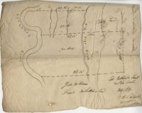
Small description of a 264 acre land, near Wappoo Creek, including land description. Names associated with this plat are John Schnerlie, Thomas S. Jones, and Edwin R. Dorrill. Notable geographic locations include the Ashley River, Wappoo Creek, Ashley Bridge Ferry Road, and Charleston District.
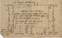
Copy of a plat of 200 acres on the neck of the Ashley River belonging to Thomas Butler. Only property outline and a few notes about the edges of the property are included. Names associated with this plat are Thomas Butler, Barker, John Bradford, and John Archdale. Notable geographic locations include the Ashley River, Clear Spring and St. Andrew's Parish.
Copy of a plat of 200 acres in St. George’s Parish. The property lines and various trees located on them are the only details included. Names associated with this plat are Benjamin Cattell, Richard Bedon, and Edward North. Notable geographic locations are St. George's Parish and Cypress.
Samuel Stent Miller apprenticed himself to Gabriel Manigault Bounetheau, a Charleston (S.C.) printer, for a period of five years. Gabriel Manigault Bounetheau was a Justice of the Peace, Clerk of Council, and a printer with an office at 3 Broad Street, according to the Charleston City Directory of 1806.
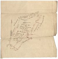
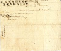
"Jonathan Burnbridge 310 acres certified for him the 24th day of December 1805. Pursuant to a warrant from Artemar B. Darby D. S. G. dated the 20th day of December 1805 having admeasured and laid out unto Jonathan Bunbridge a tract of land containing 310 acres situated in Charleston District bounded by a lain [sic] running NW and NW by land of Ralph Izard NE on land of William Stephens NE and E on land not known and by all other lines on land of Doctor William Stephens and hath such form and marks as the above plat represents Surveyed the 21 day of December 1805 Michael Byrne Dep Surveyor." Names associated with this plat are Jonathan Darby Bunbridge, B. Artemar, Ralph Izard, William Stepens, Dr. William Stephens, and Michael Byrne. Notable geographic locations include St. Bartholomew’s Parish.
200 acres laid out to Jonathan Stocks situated in Colleton County lying on the side of Kywa [Kiawah] Creek, shows surrounding properties with no land type or detail. Names associated with this plat are Jonathan Stock, John Jones, John Edenborough, Thomas Jones, and Thomas Weatherby.
Plat of 1126 acres in St. James Goose Creek on Wasamasaw [Wassamassaw] Swamp. Plat is in pencil and is difficult to read the few details, although there are a few outlines of buildings included, but difficult to tell what they are. Names associated with this plat include Daniel Gelyer, J. Ferrels, Thomas Cusack [?], and James Haney. Notable geographic locations include Wasamasaw [Wassamassaw] Swamp, Sheep Island, Goose Creek, Road to Dorchester, and Ekells Branch.
General Cutherbert's land on Big Pipe Creek. Names associated with this plat are General Cuthbert, B.H. Roberts, Ball, Peters and David DeSapah [?]. Notable geographic locations include the Savannah River.
Plat consists of 100 3/4 acres. Names associated with this plat include William Walter, William Kittlebum, Coachman, Thomas Hamilton, Benjamin, Richard and Allen. Notable geographic locations include St. George Parish and Cypress.
Plat of 419 acres near Goose Creek sold to Benjamin Wood by John Parker. Only the trees located on the property line and names on neighboring property owners are included. Names associated with this plat are John Parker, Benjamin Wood, Thomas Barker, John Barley, James Boswood, Benjamin Woods, John Stevens, Thomas Hodson, I. Drayton, Thomas Mell, and Ben Godin.
Copy of a plat of 500 acres originally laid out to John Smith, now (1805) belonging to Alexander Bower as nephew and heir to the grantee. Details include swamps, surrounding lands, and trees. Names associated with this plat are Alexander Bower, John Smith, F. Bremar, William Moultrie, Sarah Blakeway, William Cattle, and Henry Crum.
Plat of 230 acres on Johns Island. Little detail included on the plat, but there is an short explanation of the deed. Names associated with this plat are John Jones, Ebenezer Simmons, James Witter, Samuel Palmevine, John Palmavin, and Welkins. Notable geographic locations included in this plat are the Keiwaugh [Kiawah] River, Coll’s Creek, Savannah Tract, Johns Island, and Colleton County.
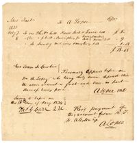
A torn letter to William Clarkson from Reverend Napoleon B. Screven with a message of Christian exhortation that Screven requests Clarkson to convey to his enslaved persons. The letter also mentions the inability to sell the wife of an enslaved man.
Two separate torn letters to William Clarkson from Reverend Richard Johnson and M. Johnson which mentions making better accommodations for the "coloured people" of the parish.
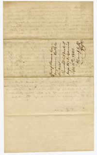
A letter from John Cheeseborough to his aunt Elizabeth Frances Blyth discussing the hiring of the enslaved man York. Makes notation that he would be "very unwilling to sell him where he could not be with his family."
A letter from John Cheeseborough to his aunt Elizabeth Frances Blyth discussing the purchase of the enslaved man York. Makes notation that he is "unwilling to sell him to any one so that he cannot occasionally see his family."
Agreement between Elizabeth Frances Blyth and overseer William Thompson outlining Thompson's duties at Friendfield and the Point Plantations which include overseeing the "negroes" with "moderation and humanity."
A 550 acre plot of land given to Francis Middleton, the entire plot is labeled as marsh located on the banks of the branches of the Santee River. Names associated with this plat are Francis Middleton, Ephraim Mitchell, Josh Purcell and A. Darby. Notable geographic locations included are St. James Parish.
Plat of 42 acres in St. George’s Parish belonging to Nathaniel Bradwell. Very little detail included with the plat. Names associated with this plat include Nathaniel Bradwell, John B. Giradeau, E.G. Montagu, John Barker, and Peter Haskins.
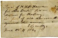
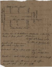
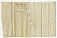
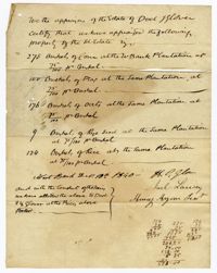
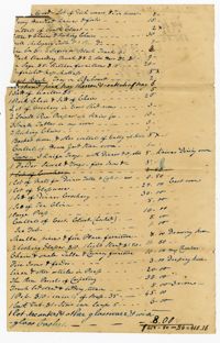
A statement from the appraisers of Doctor John Glover certifying that bushels of corn, peas, oats, rye seeds and rice were appraised from the West Bank Plantation.
Copy of plat of 342 acres on Johns Island. Very little detail, just an outline of the property with trees on the edges. Names associated with this plat are Thomas Ladson, Hanscome, Allen, William Wallisby, Robert Murens, and Brocher. Geographic locations are the Stono River, Colleton County and Johns Island.
Copy of a plan annexed to a deed for 177 acres given by Ebenezer Simmons to the John's Island Society lying adjoining the church on Johns Island. Names associated with this plat are Johns Island Society, Ebenezer Simmons, James Lawson, Robert Gibbes, William Boone, John Freer, George Scott, Thomas Smith, Daniel Doyley, Joshua Ward, John Hanyon, John Moultrie, Isaac Wraught, and John Stanyarn.
1300 acres surveyed for James Bowman, no land type or detail, shows property boundaries and neighboring plots. Names associated with this plat are James Bowman, Morris, Oswald, Warley, E.B. Fishburn, Lindsey, and B.G.O. Bryan. Notable geographic locations include New road leading to Parkers Ferry [?].
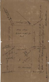
Plat consists of 50 acres titled Newington Plantation bounding on Middleton Plantation. Names associated with this plat include Johnson Middleton, N.W. Ancrum, G.H. Ingraham, R.B. Pinckney and H.A. Middleton.
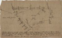
Pencil sketch of a plot of land that includes roads, creeks, and ponds, shows surrounding neighbors and little land detail. Names associated with this plat are Rich Jenkins. Notable geographic locations include Road to Bear Bluff and Wadmalaw River Marsh.
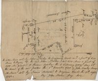
Copy of a plat of a tract of land containing 100 acres situated on the west side of branch of Black River in Craven County bounding on all sides on vacant land. Names associated with this plat are John Trough, James Bauman, Robert McDaniel, Gluscork [?], Howard, and Samuel Bunger. Geographic locations include Craven County [now in parts of Berkeley, Charleston, Georgetown, and Williamsburg counties], Black River, and Blues River.
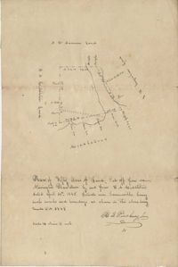
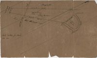
Plat of land on Goose Creek belonging to Dr. Charles Drayton. Details include an area of marsh and the location of Goose Creek. Names associated with this plat are Dr. Charles Drayton, Michau, Manigault and Richards.
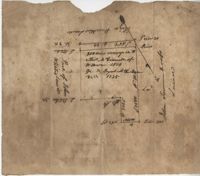
Plat contains 200 acres conveyed to Thomas McConnell of W town 1814. Granted to Duyal Mckechaw in 1735. Names associated with this plat are Thomas McConnell, Duyal Mckechaw, John Summerhoofs, Eliza Staufiur, and John White.
"Release from Thomas Osborn a Sheriff Charleston District to Philip Hart dated 6 October 1794 for a tract of land measuring and Containing 500 acres more or less situated lying and being on the Cypress Swamp in the district of Charleston Butting and Bounding Westwardly on land now or late the property of David Manll. Southwardly on lands of John Conard, Eastwardly on lands of Thomas Waring and Northeastwardly on lands belonging to Major James Postell - Sold under [?] in the property of William Doweth." Names associated with this plat are Thomas Osborn, William Dewitt, Hart, David Manll, John Conrad, Thomas Waring, Philip Hart, James Postell, and William Doweth. Notable geographic locations include St. George Parish, Cypress Swamp and Charleston District.
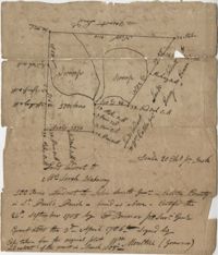
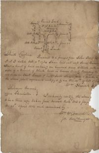
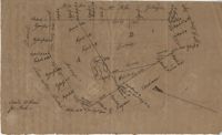
"In the above delineated plat A represents a tract of land containing 120 acres originally granted to William Sanders the 10 May 1734 for 100 acres, now held by William Allen Milis B containing 134 acres is part of a tract granted to Roger Simner the 21st day of April 1733 for 4200 acres and now held by William Edward Perry - Situated on the Cypress Swamp in St. George’s Parish Berkeley County and… a fore said and butting and bounding and having such marks and shape as are about set the Certified the 23rd July 1775 by John Fenwick Copy taken from the original in July 1801." Names associated with this plat are William Allen Milis, Roger Simner, William Edward Perry, William Benjamin Coachman, William John Glaize, Daniel Blake, William H. Drayton, Watter, Sanders, and John Fenwick. Notable geographic locations include St. George's Parish, Cypress Swamp, and Bedons.
Plat of 1,000 acres on Strawberry Bay granted to James Packer. The bay and marsh area is marked but there is little other detail included. Names associated with this plat include James Packer, William Sparkmon, James G. Ware, and W. Moultrie.
Plat of 380 acres on a great swamp near Coll. Pen Bay. Names associated with this plat are John Jones, Joseph Haynes, Lewis Oglesbee, M. Cattersloni [?], and John Rofe.
Plat of 1199 acres in St. Johns Parish. Names associated with this plat are Daniel Gelyer, Peter Sanders, James Rown, Thompson, Meadwell, S. Brichelle [?] and Maun. Notable geographic locations include Berkeley.
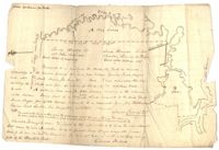
Copy of two tracts of land A and B. A containing 1144 acres, and B, containing 580 located north of the Santee River and Duck Creek for Georgetown District. John Hutchinson, Chardon, Laroche, Foijsin, Gail Huger, Isaac Huger, Mark Hugin, Ford, Job. Rothmaklen, Jospeh Purcell and Charles Parker. Notable geographic locations include Mosquito Creek, Four Mile Creek, Belin Creek Duck Creek, Minim Creek, Santee River, Winyaw Bay, and Georgetown District.
56 acre plot of land given to Radcliffe, the plot of land is bordering Cuckolds Creek, shows surrounding property owners, no land type detail or identification. Names associated with this plat are Thomas Radcliffe, Nathaniel Heyward, John Goddard and James Heyward. Notable geographic locations include Cuckolds Creek, Combahee River and St. Bartholomew's Parish.
179 acre plot of land given to Mr. Webster, shows the property lines and no land type detail. Names associated with this plat include Webster, Peters, Branford, and John James Haig. Notable geographic locations include the Pon Pon River.
Journal kept by Alexander Glennie concerning his activities as rector of All Saints (Episcopal) Church, Waccamaw, South Carolina. Includes a list of plantation chapels (Woodbourne, Laurel Hill, Brookgreen, Oaks, Litchfield, Waverly, Midway, True Blue, Hagley, Fairfield, Sandy Knoll, Cedar Grove, and Mount Arena); the constitution (1832) and minutes (1832-1838) of All Saints Sunday School (an auxiliary of the Diocesan Sunday School Society of South Carolina); and a circular. The bulk of Glennie's journal contains the names of churches and plantations visited and the names of people (both free and enslaved) for whom he performed marriage, baptism, funeral, and other religious ceremonies/sacrament. Occasional summaries of the number of communicants served and financial support received are also included. A printed circular (1831), "Constitution of the Diocesan Sunday Society School of South-Carolina," is attached to the inside front over of the volume.
The John Ball Plantation Account Book, 1812-1834, is an indexed account book kept by overseers at various plantations owned by the Ball family. Overseers named are John Cox, Arthur McFarland, Samuel Lynes, Alexander McKnight, Britton Bunch, John Dickson, Thomas Fincklea, James Coward, and John Page. Of particular interest are two different accounts, one with William Deas, referred to as a "Mulatto" and the other "Free Nancy," a free black woman at Limerick Plantation who was buying and trading rice and sugar.
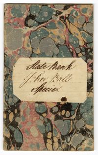
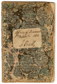
John Ball's Office of Discount Deposit Book, 1803, is a bound volume kept by John Ball Sr. recording finances for various persons including members of the Gadsden, Prioleau and Ball families.
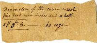
1806, 1822, 1809, 1820, 1808, 1821, 1807, and 1810-1819
Description:
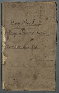
The Day Book for Henry Ravenel Junior, Wood Ville, 1806-1822, is a book divided into two sections. The first section lists the names of slaves and their decedents, lists of purchased slaves with name, name of previous owner, date and price, and slaves who received shoes. The second half, which appears upside down, records family events, visits to the Pineville theatre, traveling, engagements, marriages, deaths, and attendance at the Jockey Club. Also included are entries about a hunting party to capture or kill fugitive slaves, the promise of emancipation for two female "mulatto" child slaves, and a trial over the body of a slave woman who was punished to death. This book contains a second use written upside-down and back to front.
The Medical Account Book of Dr. George Paddon Bond Hasell contains medical entries on visits and treatments for Georgetown County plantation families and their slaves between 1812-1816. The book is written in both English and Latin and references enslaved people by their first name, the name of their slave owner or by using the letter "N" before their name.
The Andrew Hasell Medical Account Book between the years 1830-1842 is a book listing Dr. Andrew Hasell?s visitations to ill or injured patients on various plantations throughout Georgetown County, South Carolina. His book documents the diseases, injuries, surgical procedures and deaths of patients that include enslaved men, women, and children. Some pages are written in partial latin.


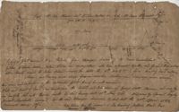

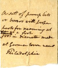
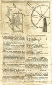
![Letter from N[athan] and D[avid] Sellers (brothers) to Henry Laurens, Jr.](https://iiif.library.cofc.edu/iiif/2/45436/full/200,/0/default.jpg)
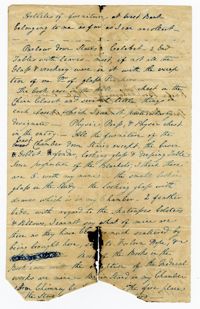
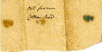
![The Results of an experiment made to extract an [Experimental] oil from Cotton Seed](https://iiif.library.cofc.edu/iiif/2/47338/full/200,/0/default.jpg)