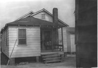
House (rear and side view) on site affected by the construction of Interstate 26 (I-26). Surveyor notations on back of photo: "Dkt.: 10.490. Property owner: Rosa Brown. Tract: 37. Station: 5797+00 Rt. Line 'A'. Date: September 11, 1962. In R/W - Bought." [See collection description for explanation of surveyor notations.]
House (rear view) on site affected by the construction of Interstate 26 (I-26). [Building address number 2003(?).]Surveyor notations on back of photo: "Dkt.: 10.490. Property owner: L. Bradley. Tract: 39. Station: 5797+70 on CL Line 'G'. Date: September 11, 1962. In R/W - Bought." [See collection description for explanation of surveyor notations.]
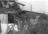
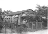
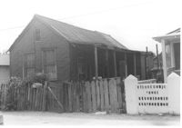
House in somewhat dilapidated condition, possibly rear view (obscured by tall grass), on site affected by the construction of Interstate 26 (I-26). Surveyor notations on back of photo: "Dkt.: 10.490. Property owner: Sylvia Yaschik. Tract: 40. Station: 5798+00 on CL Line 'G'. Date: September 12, 1962. In R/W - Bought." [See collection description for explanation of surveyor notations.]
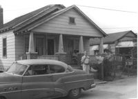
House on site affected by the construction of Interstate 26 (I-26). Building address number 2009(?). Surveyor notations on back of photo: "Dkt.: 10.490. Property owner: John Simmons, Est. Tract: 42. Station: 5798+60 on CL Line 'G'. Date: September 12, 1962. In R/W - Bought." [See collection description for explanation of surveyor notations.]
House (rear view) on site affected by the construction of Interstate 26 (I-26). [Building address number 2009(?).] Surveyor notations on back of photo: "Dkt.: 10.490. Property owner: John Simmons, Est. Tract: 42. Station: 5798+60 on CL Line 'G'. Date: September 12, 1962. In R/W - Bought." [See collection description for explanation of surveyor notations.]
House on site affected by the construction of Interstate 26 (I-26). Surveyor notations on back of photo: "Dkt.: 10.490. Property owner: Lillian Ferguson. Tract: 43. Station: 5799+00 Rt. Line 'G.' Date: September 12, 1962. In R/W - Bought." [See collection description for explanation of surveyor notations.]
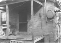
House (rear view, back porch) on site affected by the construction of Interstate 26 (I-26). Surveyor notations on back of photo: "Dkt.: 10.490. Property owner: Lillian Ferguson. Tract: 43. Station: 5799+00 Rt. Line 'G.' Date: September 12, 1962. In R/W - Bought." [See collection description for explanation of surveyor notations.]
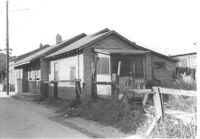
House on site affected by the construction of Interstate 26 (I-26). Surveyor notations on back of photo: "Dkt.: 10.490. Property owner: Nathaniel Phoenix. Tract: 46. Station: 5800+00 Rt. Line 'G'. Date: September 11, 1962. In R/W - Bought." [See collection description for explanation of surveyor notations.]
House on site affected by the construction of Interstate 26 (I-26). (See I-26 Photo 1138, rear view.) Surveyor notations on back of photo: "Dkt.: 10.490. Property owner: Nathaniel Phoenix. Tract: 46. Station: 5799+65 Rt. Line 'G'. Date: September 11, 1962. Proximity." [See collection description for explanation of surveyor notations.]
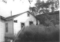
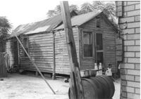
House (rear view) on site affected by the construction of Interstate 26 (I-26). Surveyor notations on back of photo: "Dkt.: 10.490. Property owner: Thomasina Goss. Tract: 47. Station: 5799+90 Rt. Line 'G'. Date: September 11, 1962. Proximity." [See collection description for explanation of surveyor notations.]
Right of way--South Carolina--Charleston County, Highway planning--South Carolina--Charleston County, Vernacular architecture--South Carolina--Charleston County, Lost architecture--South Carolina--Charleston County, Dwellings--South Carolina--Charleston County✖[remove]348