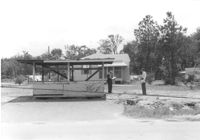
Lot with what appears to be a roadside stand; house in background, on site affected by the construction of Interstate 26 (I-26). Surveyor notations on back of photo: "Dkt.: 10.480. Property owner: Marshall A. Radford, et al. Tract: 101. Station: 60+20 Lt. (Goodrich Road). Date: May 2, 1961. In R/W - Bought." [See collection description for explanation of surveyor notations.]
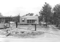
Lot with what appears to be a roadside stand; house in background, on site affected by the construction of Interstate 26 (I-26). Surveyor notations on back of photo: "Dkt.: 10.480. Property owner: Marshall A. Radford, et al. Tract: 101. Station: 60+20 Lt. (Goodrich Road). Date: May 2, 1961. Proximity." [See collection description for explanation of surveyor notations.]
Right of way--South Carolina--Charleston County, Highway planning--South Carolina--Charleston County, Vernacular architecture--South Carolina--Charleston County, Lost architecture--South Carolina--Charleston County, Dwellings--South Carolina--Charleston County, Roadside stands--South Carolina--Charleston County✖[remove]2