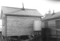
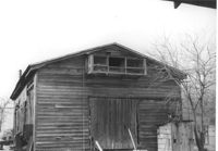
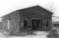
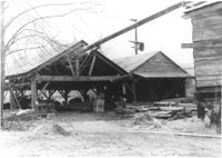
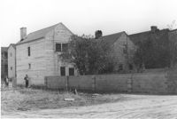
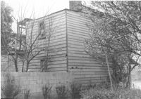
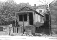
Rear view of shed (railroad building) on site affected by the construction of Interstate 26 (I-26). Address: 19½ Poinsett Street (rear). Surveyor notations on back of photo: "Dkt.: 10.503. Property owner: S.A.L.R.R. Tract: 105. Station: 5924+40 Lt. Date: Feb. 20, 1963." [See collection description for explanation of surveyor notations.]
Rear view of shed (railroad building) on site affected by the construction of Interstate 26 (I-26). Address: 19½ Poinsett Street (rear). Surveyor notations on back of photo: "Dkt.: 10.503. Property owner: S.A.L.R.R. Tract: 105. Station: 5924+40 Rt. & Lt. Date: Feb. 20, 1963." [See collection description for explanation of surveyor notations.]
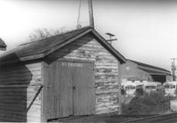
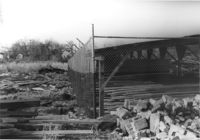
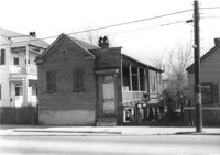
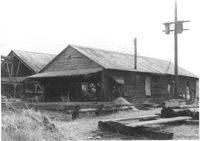
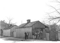
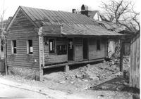
Shed (railroad building) along railroad tracks, on site affected by the construction of Interstate 26 (I-26). Address: 19½ Poinsett Street (rear). Trolley barn on 665 Meeting Street, and buses, in background. Surveyor notations on back of photo: "Dkt.: 10.503. Property owner: S.A.L.R.R. Tract: 105. Station: 5924+40 Rt. & Lt. Date: Feb. 20, 1963." [See collection description for explanation of surveyor notations.]
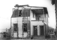
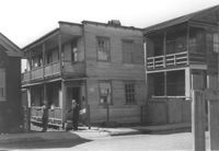
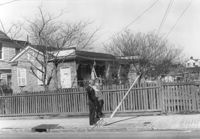
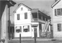
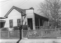
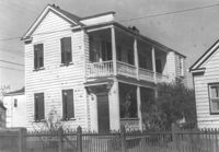
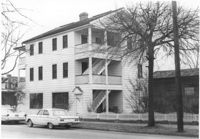
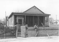
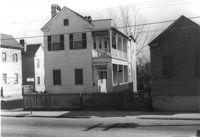
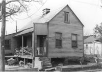
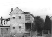
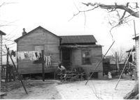
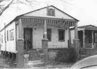
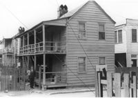
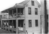
House (corner view, rear) on site affected by the construction of Interstate 26 (I-26). Unnumbered house, on unnamed road, behind 35 Poinsett Street. Trolley barn on 665 Meeting Street, and buses, in background. Surveyor notations on back of photo: "Dkt.: 10.503. Property owner: Manuel F. Fernandez. Tract: 106. Station: 5923+80 Lt. Date: Feb. 20, 1963. In R/W - Bought." [See collection description for explanation of surveyor notations.]
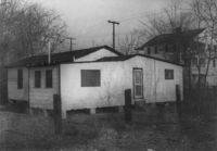
House on site affected by the construction of Interstate 26 (I-26). Unnumbered house, on unnamed road, behind 35 Poinsett Street. Surveyor notations on back of photo: "Dkt.: 10.503. Property owner: Manuel F. Fernandez. Tract: 106. Station: 5923+80 Lt. Date: Feb. 20, 1963. In R/W - Bought." [See collection description for explanation of surveyor notations.]
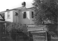
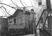
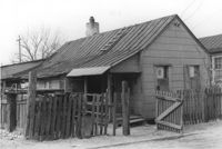
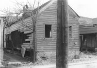
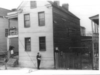
Dilapidated structure on site affected by the construction of Interstate 26 (I-26). Address: 35½ Poinsett Street. Bus in background. Surveyor notations on back of photo: "Dkt.: 10.503. Property owner: Manuel F. Fernandez. Tract: 106. Station: 5923+10 Lt. Date: Feb. 20, 1963. In R/W - Bought." [See collection description for explanation of surveyor notations.]
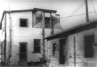
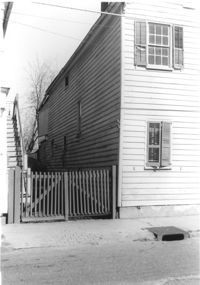
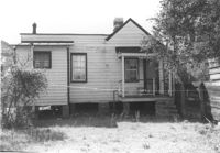
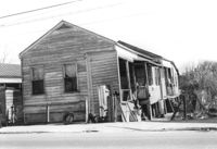
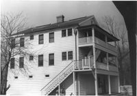
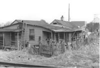
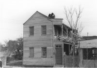
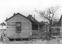
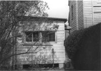
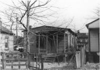
House in dilapidated condition (freedman's cottage) (rear view) on site affected by the construction of Interstate 26 (I-26). Address: 7 Poinsett Street. Surveyor notations on back of photo: "Dkt.: 10.503. Property owner: Manuel F. Fernandez. Tract: 106. Station: 5923+50 Lt. Date: Feb. 20, 1963. In R/W - Bought." [See collection description for explanation of surveyor notations.]
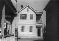
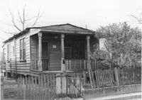
House in dilapidated condition (freedman's cottage) on site affected by the construction of Interstate 26 (I-26). Address: 7 Poinsett Street. Number 23 painted on door. Surveyor notations on back of photo: "Dkt.: 10.503. Property owner: Manuel F. Fernandez. Tract: 106. Station: 5923+50 Lt. Date: Feb. 20, 1963. In R/W - Bought." [See collection description for explanation of surveyor notations.]
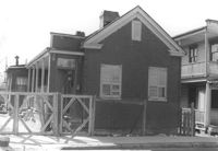
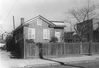
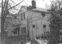
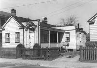
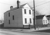
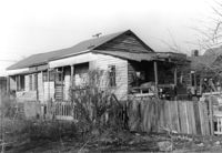
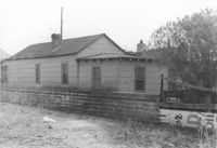
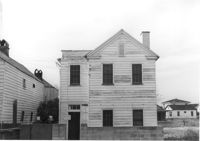
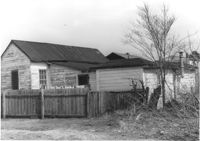
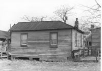
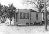
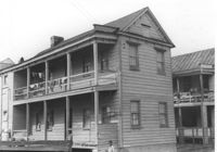
House in dilapidated condition on site affected by the construction of Interstate 26 (I-26). Address: 35 Poinsett Street. Surveyor notations on back of photo: "Dkt.: 10.503. Property owner: Manuel F. Fernandez. Tract: 106. Station: 5922+50 Lt. Date: Feb. 20, 1963. In R/W - Bought." [See collection description for explanation of surveyor notations.]
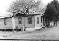
House in dilapidated condition (rear view) and smaller dwelling, on site affected by the construction of Interstate 26 (I-26). Address: 35 Poinsett Street. Surveyor notations on back of photo: "Dkt.: 10.503. Property owner: Manuel F. Fernandez. Tract: 106. Station: 5922+50 Lt. Date: Feb. 20, 1963. In R/W - Bought." [See collection description for explanation of surveyor notations.]
Freedman's cottage on site affected by the construction of the Crosstown. Address: 173 Nassau Street. Surveyor notations on back of photo: "Dkt.: 10.518. Property owner: Isiah Bryant, et al. Tract: 25. Station: 41+00 Lt. N.B. lane Route 17. Date: Mar. 6, 1963. In R/W - Bought. [See collection description for explanation of surveyor notations.]
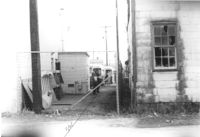
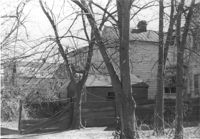
Lot between buildings, on site affected by the construction of Interstate 26 (I-26). Address: 35 Poinsett Street. Buses in background. Surveyor notations on back of photo: "Dkt.: 10.503. Property owner: S.C. Electric & Gas Co. [Tract number not indicated.] Station: 5922+50 Lt. Date: Feb. 20, 1963. Proximity." [See collection description for explanation of surveyor notations.]
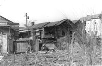
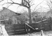
Fenced-in lot between buildings with bricks and lumber strewn about, on site affected by the construction of Interstate 26 (I-26). Located south of 35 Poinsett Street. Surveyor notations on back of photo: "Dkt.: 10.503. Property owner: Carolina Dismantling Corp. Tract: 109-A. Station: 5928± to 5929± Lt. Date: Feb. 20, 1963." [See collection description for explanation of surveyor notations.]
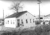
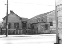
Free Kindergarten (corner view, rear) on site affected by the construction of Interstate 26 (I-26). Address: 20 Huger Street. Surveyor notations on back of photo: "Dkt.: 10.503. Property owner: Free Kindergarten Assoc. of Chas. Tract: 113. Station: 5936+50 Rt. CL. Date: Feb. 20, 1963. In R/W - Bought." [See collection description for explanation of surveyor notations.]
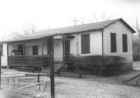
Free Kindergarten on site affected by the construction of Interstate 26 (I-26). Address: 20 Huger Street. Surveyor notations on back of photo: "Dkt.: 10.503. Property owner: Free Kindergarten Assoc. of Chas. Tract: 113. Station: 5936+50 Rt. & Lt. CL. Date: Feb. 20, 1963. In R/W - Bought." [See collection description for explanation of surveyor notations.]
Freedman's cottage on site affected by the construction of the Crosstown. Address: 173 Nassau Street. Surveyor notations on back of photo: "Dkt.: 10.518. Property owner: Isiah Bryant, et al. Tract: 25. Station: 41+00 Lt. N.B. lane Route 17. Date: Mar. 6, 1963. In R/W - Bought. [See collection description for explanation of surveyor notations.]
House on site affected by the construction of the Crosstown. Address: 177 Nassau Street. 179 Nassau Street partly seen to its right. Surveyor notations on back of photo: "Dkt.: 10.518. Property owner: Estelle Tompkins. Tract: 26. Station: 41+25 Lt. N.B. lane Route 17. Date: Mar. 6, 1963. Proximity. [See collection description for explanation of surveyor notations.]
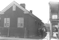
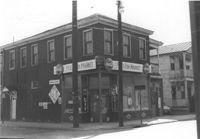
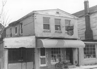
Building (residential and commercial) on site affected by the construction of the Crosstown. Address: 71 Lee Street. Sign for Ingram Fish Market on side of building. Surveyor notations on back of photo: "Dkt.: 10.518. Property owner: Virginia E.R. Ehlers. Tract: 28. Station: 41+15 CL S.B. lane Route 17. Date: Mar. 6, 1963. In R/W - Bought. [See collection description for explanation of surveyor notations.]
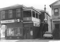
Pye's Fish Market, on site affected by the construction of the Crosstown. Address: 71 Lee Street. View of street corner. Same building as previous two photographs. `Surveyor notations on back of photo: "Dkt.: 10.518. Property owner: Virginia E.R. Ehlers. Tract: 28. Station: 41+15 CL S.B. lane Route 17. Date: Mar. 6, 1963. In R/W - Bought. [See collection description for explanation of surveyor notations.]
Pye's Fish Market, on site affected by the construction of the Crosstown. Address: 71 Lee Street. Same building as previous three photographs. `Surveyor notations on back of photo: "Dkt.: 10.518. Property owner: Virginia E.R. Ehlers. Tract: 28. Station: 41+15 CL S.B. lane Route 17. Date: Mar. 6, 1963. In R/W - Bought. [See collection description for explanation of surveyor notations.]
House on site affected by the construction of the Crosstown. Address: 73 Lee Street. Surveyor notations on back of photo: "Dkt.: 10.518. Property owner: Virginia E.R. Ehlers. Tract: 28. Station: 40+75 CL S.B. lane Route 17. Date: Mar. 6, 1963. In R/W - Bought. [See collection description for explanation of surveyor notations.]
Rear view of houses on site affected by the construction of the Crosstown. Address: 75 Lee Street. Surveyor notations on back of photo: "Dkt.: 10.518. Property owner: Virginia E.R. Ehlers. Tract: 28. Station: 40+50 & 40+75 CL S.B. lane of Route 17. Date: Mar. 6, 1963. In R/W - Bought. [See collection description for explanation of surveyor notations.]
House on site affected by the construction of the Crosstown. Address: 75 Lee Street. Sign on side elevation: Moved to Isle of Palms Boat Landing. Surveyor notations on back of photo: "Dkt.: 10.518. Property owner: Virginia E.R. Ehlers. Tract: 28. Station: 40+50 CL S.B. lane of Route 17. Date: Mar. 6, 1963. In R/W - Bought. [See collection description for explanation of surveyor notations.]
Rear view of house and lot on site affected by the construction of the Crosstown. Address: 75 Lee Street. Surveyor notations on back of photo: "Dkt.: 10.518. Property owner: Virginia E.R. Ehlers. Tract: 28. Station: 40+50 Rt. S.B. lane of Route 17. Date: Mar. 6, 1963. In R/W - Bought. [See collection description for explanation of surveyor notations.]
House with picket fence, on site affected by the construction of the Crosstown. Address: 172 Nassau Street. Surveyor notations on back of photo: "Dkt.: 10.518. Property owner: Philip Baskerville, Est. Tract: 30. Station: 42+00 Rt. N.B. lane Route 17. Date: Mar. 6, 1963. In R/W - Bought. [See collection description for explanation of surveyor notations.]
House with picket fence, on site affected by the construction of the Crosstown. Address: 172 Nassau Street. Surveyor notations on back of photo: "Dkt.: 10.518. Property owner: Philip Baskerville, Est. Tract: 30. Station: 42+00 Rt. N.B. lane Route 17. Date: Mar. 6, 1963. In R/W - Bought. [See collection description for explanation of surveyor notations.]
House on site affected by the construction of the Crosstown. Address: 174 Nassau Street. Surveyor notations on back of photo: "Dkt.: 10.518. Property owner: Alberta Jackson Mack. Tract: 31. Station: 42+00 CL N.B. lane Route 17. Date: Mar. 6, 1963. In R/W - Bought. [See collection description for explanation of surveyor notations.]
House on site affected by the construction of the Crosstown. Address: 174 Nassau Street. Surveyor notations on back of photo: "Dkt.: 10.518. Property owner: Alberta Jackson Mack. Tract: 31. Station: 42+00 CL N.B. lane Route 17. Date: Mar. 6, 1963. In R/W - Bought. [See collection description for explanation of surveyor notations.]
House on site affected by the construction of the Crosstown. Address: 174 Nassau Street. Surveyor notations on back of photo: "Dkt.: 10.518. Property owner: Alberta Jackson Mack. Tract: 31. Station: 42+00 CL N.B. lane Route 17. Date: Mar. 6, 1963. In R/W - Bought. [See collection description for explanation of surveyor notations.]
House on site affected by the construction of the Crosstown. Address: 176 Nassau Street. Surveyor notations on back of photo: "Dkt.: 10.518. Property owner: Carole B. Priester. Tract: 32. Station: 42+05 Lt. N.B. lane Route 17. Date: Mar. 6, 1963. In R/W - Bought. [See collection description for explanation of surveyor notations.]
House (rear view) on site affected by the construction of the Crosstown. Address: 176 Nassau Street. Surveyor notations on back of photo: "Dkt.: 10.518. Property owner: Carole B. Priester. Tract: 32. Station: 42+05 Lt. N.B. lane Route 17. Date: Mar. 6, 1963. In R/W - Bought. [See collection description for explanation of surveyor notations.]
House (rear view) on site affected by the construction of the Crosstown. Address: 176 Nassau Street. Surveyor notations on back of photo: "Dkt.: 10.518. Property owner: Carole B. Priester. Tract: 32. Station: 42+35 Lt. N.B. lane Route 17. Date: Mar. 6, 1963. In R/W - Bought. [See collection description for explanation of surveyor notations.]
House (rear view) on site affected by the construction of the Crosstown. Address: 178 Nassau Street. Surveyor notations on back of photo: "Dkt.: 10.518. Property owner: Euphrasia E. Lewis. Tract: 33. Station: 42+10 Lt. N.B. lane Route 17. Date: Mar. 6, 1963. In R/W - Bought. [See collection description for explanation of surveyor notations.]
House on site affected by the construction of the Crosstown. Address: 178 Nassau Street. Surveyor notations on back of photo: "Dkt.: 10.518. Property owner: Euphrasia E. Lewis. Tract: 33. Station: 42+10 Lt. N.B. lane Route 17. Date: Mar. 6, 1963. In R/W - Bought. [See collection description for explanation of surveyor notations.]
House on site affected by the construction of the Crosstown. Address: 180 Nassau Street. Surveyor notations on back of photo: "Dkt.: 10.518. Property owner: Audrey Lewis Clark, et al. Tract: 34. Station: 42+05 Rt. S.B. lane Route 17. Date: Mar. 6, 1963. In R/W - Bought. [See collection description for explanation of surveyor notations.]
House (side view) on site affected by the construction of the Crosstown. Address180 Nassau Street. Surveyor notations on back of photo: "Dkt.: 10.518. Property owner: Audrey Lewis Clark, et al. Tract: 34. Station: 42+05 Rt. S.B. lane Route 17. Date: Mar. 6, 1963. In R/W - Bought. [See collection description for explanation of surveyor notations.]
House (rear view) on site affected by the construction of the Crosstown. Address: 182 Nassau Street. Surveyor notations on back of photo: "Dkt.: 10.518. Property owner: Euphrasia E. Lewis. Tract: 35. Station: 42+00 Lt. S.B. lane Route 17. Date: Mar. 6, 1963. In R/W - Bought. [See collection description for explanation of surveyor notations.]
House on site affected by the construction of the Crosstown. Address: 182 Nassau Street. Surveyor notations on back of photo: "Dkt.: 10.518. Property owner: Euphrasia E. Lewis. Tract: 35. Station: 42+00 Lt. S.B. lane Route 17. Date: Mar. 6, 1963. In R/W - Bought. [See collection description for explanation of surveyor notations.]
House (corner view) on site affected by the construction of the Crosstown. Address: 182 Nassau Street. View of street corner. Surveyor notations on back of photo: "Dkt.: 10.518. Property owner: Euphrasia E. Lewis. Tract: 35. Station: 42+00 Lt. S.B. lane Route 17. Date: Mar. 6, 1963. In R/W - Bought. [See collection description for explanation of surveyor notations.]
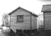
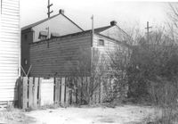
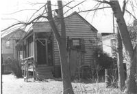
Storage shed on site affected by the construction of the Crosstown. Address182 Nassau Street. Surveyor notations on back of photo: "Dkt.: 10.518. Property owner: Euphrasia E. Lewis. Tract: 35. Station: 42+40 CL S.B. lane Route 17. Date: Mar. 6, 1963. In R/W - Bought. [See collection description for explanation of surveyor notations.]
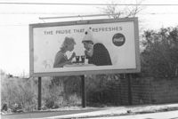
Lot on site affected by the construction of the Crosstown, with billboard for Coca-Cola (The Pause that Refreshes). Address: 67 Lee Street. Surveyor notations on back of photo: "Dkt.: 10.518. Property owner: Edward Washington. Tract: 36. Station: 43+00 Lt. S.B. lane Route 17. Date: Mar. 6, 1963. Sign. [See collection description for explanation of surveyor notations.]
House on site affected by the construction of the Crosstown. Address: 65 Lee Street. Surveyor notations on back of photo: "Dkt.: 10.518. Property owner: Inez Moore. Tract: 37. Station: 43+30 CL and Rt. S.B. lane Route 17. Date: Mar. 6, 1963. In R/W - Bought. [See collection description for explanation of surveyor notations.]
House (rear view) on site affected by the construction of the Crosstown. Address: 65 Lee Street. Surveyor notations on back of photo: "Dkt.: 10.518. Property owner: Inez Moore. Tract: 37. Station: 43+30 CL and Rt. S.B. lane Route 17. Date: Mar. 6, 1963. In R/W - Bought. [See collection description for explanation of surveyor notations.]
House (rear view) on site affected by the construction of the Crosstown. Address: 63 Lee Street. Surveyor notations on back of photo: "Dkt.: 10.518. Property owner: Peter Bennett, Est. Tract: 38. Station: 43+65 Rt. S.B. lane Route 17. Date: Mar. 6, 1963. In R/W - Bought. [See collection description for explanation of surveyor notations.]
House on site affected by the construction of the Crosstown. Address: 63 Lee Street. Building Address: number 3. Surveyor notations on back of photo: "Dkt.: 10.518. Property owner: Peter Bennett, Est. Tract: 38. Station: 43+65 Rt. S.B. lane Route 17. Date: Mar. 6, 1963. In R/W - Bought. [See collection description for explanation of surveyor notations.]
House on site affected by the construction of the Crosstown. Address: 61 Lee Street. Surveyor notations on back of photo: "Dkt.: 10.518. Property owner: Sabrina Frost, Est. Tract: 39. Station: 44+00 CL S.B. lane Route 17. Date: Mar. 6, 1963. In R/W - Bought. [See collection description for explanation of surveyor notations.]
House (rear view) on site affected by the construction of the Crosstown. Address: 61 Lee Street. Surveyor notations on back of photo: "Dkt.: 10.518. Property owner: Sabrina Frost, Est. Tract: 39. Station: 44+00 CL S.B. lane Route 17. Date: Mar. 6, 1963. In R/W - Bought. [See collection description for explanation of surveyor notations.]
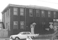
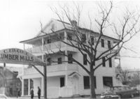
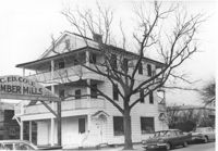
Cole Lumber Company, presumably main office building, on site affected by the construction of Interstate 26 (I-26). Sign arches over the entrance: C. Ed Cole Lumber Mills. Address from 1961 City Directory: 293 Huger Street. Address from 1951 Sanborn Map: 17 Huger Street. Surveyor notations on back of photo: "Dkt.: 10.517. Property owner: Charles E. Cole Lumber Co. Tract 1. Station: 5937+70 Lt. Date: February 21, 1963." [See collection description for explanation of surveyor notations.]
Cole Lumber Company, presumably main office building, on site affected by the construction of Interstate 26 (I-26). Address from 1961 City Directory: 293 Huger Street. Address from 1951 Sanborn Map: 17 Huger Street. Surveyor notations on back of photo: "Dkt.: 10.517. Property owner: Charles E. Cole Lumber Co. Tract 1. Station: 5937+70 Lt. Date: February 21, 1963." [See collection description for explanation of surveyor notations.]
Cole Lumber Company, presumably main office building, on site affected by the construction of Interstate 26 (I-26). Address from 1961 City Directory: 293 Huger Street. Address from 1951 Sanborn Map: 17 Huger Street. Surveyor notations on back of photo: "Dkt.: 10.517. Property owner: Cole Lumber Co. Tract 1. Station: 5937+70 Lt. Date: March 5, 1963. In R/W - Bought." [See collection description for explanation of surveyor notations.]
Cole Lumber Company, presumably main office building, on site affected by the construction of Interstate 26 (I-26). Address from 1961 City Directory: 293 Huger Street. Address from 1951 Sanborn Map: 17 Huger Street. Surveyor notations on back of photo: "Dkt.: 10.517. Property owner: Cole Lumber Co. Tract 1. Station: 5937+70 Lt. Date: March 5, 1963. In R/W - Bought." [See collection description for explanation of surveyor notations.]
Cole Lumber Company, presumably main office building, on site affected by the construction of Interstate 26 (I-26). Address from 1961 City Directory: 293 Huger Street. Address from 1951 Sanborn Map: 17 Huger Street. Surveyor notations on back of photo: "Dkt.: 10.517. Property owner: Charles E. Cole Lumber Co. Tract 1. Station: 5937+70 Lt. Date: February 21, 1963." [See collection description for explanation of surveyor notations.]
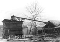
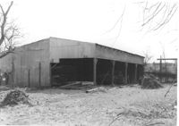
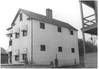
Cole Lumber Company structure, on site affected by the construction of Interstate 26 (I-26). Address from 1961 City Directory: 293 Huger Street. Address from 1951 Sanborn Map: 17 Huger Street. Surveyor notations on back of photo: "Dkt.: 10.517. Property owner: Charles E. Cole Lumber Co. Tract 1. Station: 5938+40 CL. Date: February 21, 1963." [See collection description for explanation of surveyor notations.]
Cole Lumber Company structure (rear view), on site affected by the construction of Interstate 26 (I-26). Address from 1961 City Directory: 293 Huger Street. Address from 1951 Sanborn Map: 17 Huger Street. Surveyor notations on back of photo: "Dkt.: 10.517. Property owner: Charles E. Cole Lumber Co. Tract 1. Station: 5938+40 CL. Date: February 21, 1963." [See collection description for explanation of surveyor notations.]
House (corner view, rear) on site affected by the construction of the Crosstown. Address: 59 Lee Street (corner of Lee Street and Hanover Street). Looking towards street corner. Surveyor notations on back of photo: "Dkt.: 10.518. Property owner: Melvin Whaley. Tract: 40. Station: 44+35 Rt. S.B. lane Route 17. Date: Mar. 6, 1963. In R/W - Bought. [See collection description for explanation of surveyor notations.]
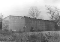
Cole Lumber Company structures, on site affected by the construction of Interstate 26 (I-26). Address from 1961 City Directory: 293 Huger Street. Address from 1951 Sanborn Map: 17 Huger Street. Surveyor notations on back of photo: "Dkt.: 10.517. Property owner: Cole Lumber Co. Tract 1. Station: 5938+80 Lt. Date: February 21, 1963." [See collection description for explanation of surveyor notations.]
Cole Lumber Company structures, on site affected by the construction of Interstate 26 (I-26). Address from 1961 City Directory: 293 Huger Street. Address from 1951 Sanborn Map: 17 Huger Street. Surveyor notations on back of photo: "Dkt.: 10.517. Property owner: Cole Lumber Co. Tract 1. Station: 5938+80 Lt. Date: February 21, 1963." [See collection description for explanation of surveyor notations.]
Cole Lumber Company structures, on site affected by the construction of Interstate 26 (I-26). Address from 1961 City Directory: 293 Huger Street. Address from 1951 Sanborn Map: 17 Huger Street. Surveyor notations on back of photo: "Dkt.: 10.517. Property owner: Cole Lumber Co. Tract 1. Station: 5939+50 CL. Date: February 21, 1963." [See collection description for explanation of surveyor notations.]
Cole Lumber Company structures, on site affected by the construction of Interstate 26 (I-26). Address from 1961 City Directory: 293 Huger Street. Address from 1951 Sanborn Map: 17 Huger Street. Surveyor notations on back of photo: "Dkt.: 10.517. Property owner: Cole Lumber Co. Tract 1. Station: 5939+50 CL. Date: February 21, 1963." [See collection description for explanation of surveyor notations.]
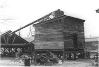
Cole Lumber Company structure, on site affected by the construction of Interstate 26 (I-26). Address from 1961 City Directory: 293 Huger Street. Address from 1951 Sanborn Map: 17 Huger Street. Surveyor notations on back of photo: "Dkt.: 10.517. Property owner: Cole Lumber Co. Tract 1. Station: 5940+00 Lt. Date: February 21, 1963." [See collection description for explanation of surveyor notations.]
Cole Lumber Company structure (rear view), on site affected by the construction of Interstate 26 (I-26). Address from 1961 City Directory: 293 Huger Street. Address from 1951 Sanborn Map: 17 Huger Street. Surveyor notations on back of photo: "Dkt.: 10.517. Property owner: Cole Lumber Co. Tract 1. Station: 5940+00 Lt. Date: February 21, 1963." [See collection description for explanation of surveyor notations.]
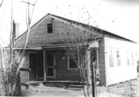
House on site affected by the construction of Interstate 26 (I-26). Address: 21 D Street. Surveyor notations on back of photo: "Dkt.: 10.517. Property owner: Ida B. Moore. Tract 3. Station: 5943+35 Rt. on CL. Date: February 21, 1963. In R/W - Bought." [See collection description for explanation of surveyor notations.]
House (rear view) on site affected by the construction of Interstate 26 (I-26). Address: 21 D Street (see 1951 Sanborn Map). Surveyor notations on back of photo: "Dkt.: 10.517. Property owner: Ida B. Moore. Tract 3. Station: 5943+35 Rt. on CL. Date: February 21, 1963. In R/W - Bought." [See collection description for explanation of surveyor notations.]
House (freedman's cottage) (rear view) on site affected by the construction of Interstate 26 (I-26). Address: 23 D Street. Surveyor notations on back of photo: "Dkt.: 10.517. Property owner: Maggie Tobias. Tract: 4. Station: 5945+65 Rt. on CL. Date: February 21, 1963. In R/W - Bought." [See collection description for explanation of surveyor notations.]
House (freedman's cottage) on site affected by the construction of Interstate 26 (I-26). Address: 23 D Street. Surveyor notations on back of photo: "Dkt.: 10.517. Property owner: Maggie Tobias. Tract: 4. Station: 5945+65 Rt. on CL. Date: February 21, 1963. In R/W - Bought." [See collection description for explanation of surveyor notations.]
House on site affected by the construction of the Crosstown. Address: 59 Lee Street (corner of Lee Street and Hanover Street). Surveyor notations on back of photo: "Dkt.: 10.518. Property owner: Melvin Whaley. Tract: 40. Station: 44+35 Rt. S.B. lane Route 17. Date: Mar. 6, 1963. In R/W - Bought. [See collection description for explanation of surveyor notations.]
House (rear view) on site affected by the construction of Interstate 26 (I-26). Address: 47 C Street. (1951 Sanborn map indicates the address is 16 C Street.) Surveyor notations on back of photo: "Dkt.: 10.517. Property owner: James B. Walker, et al. Tract: 6. Station: 5944+00 Lt. - Line 6. Date: February 21, 1963. In R/W - Bought." [See collection description for explanation of surveyor notations.]
House on site affected by the construction of Interstate 26 (I-26). Address: 47 C Street. (1951 Sanborn map indicates the address is 16 C Street.) Surveyor notations on back of photo: "Dkt.: 10.517. Property owner: James B. Walker, et al. Tract: 6. Station: 5944+00 Lt. - Line 6. Date: February 21, 1963. In R/W - Bought." [See collection description for explanation of surveyor notations.]
House on site affected by the construction of Interstate 26 (I-26). Address: 18 D Street. Surveyor notations on back of photo: "Dkt.: 10.517. Property owner: Annie Marie Brown. Tract: 7. Station: 5944+15 CL - Line 6. Date: February 21, 1963. In R/W - Bought." [See collection description for explanation of surveyor notations.]
House (rear view) on site affected by the construction of Interstate 26 (I-26). Address: 18 D Street. Surveyor notations on back of photo: "Dkt.: 10.517. Property owner: Annie Marie Brown. Tract: 7. Station: 5944+15 CL - Line 6. Date: February 21, 1963. In R/W - Bought." [See collection description for explanation of surveyor notations.]
House on site affected by the construction of Interstate 26 (I-26). Address: 19 D Street. Surveyor notations on back of photo: "Dkt.: 10.517. Property owner: Mary M. Lee. Tract: 10. Station: 5944+50 CL - Line 1. Date: February 21, 1963. In R/W - Bought." [See collection description for explanation of surveyor notations.]
House (rear view) on site affected by the construction of Interstate 26 (I-26). Address: 19 D Street. Surveyor notations on back of photo: "Dkt.: 10.517. Property owner: Mary M. Lee. Tract: 10. Station: 5944+50 CL - Line 1. Date: February 21, 1963. In R/W - Bought." [See collection description for explanation of surveyor notations.]
House (freedman's cottage?) (rear view) on site affected by the construction of Interstate 26 (I-26). Address: 15½ D Street. Surveyor notations on back of photo: "Dkt.: 10.517. Property owner: Rebecca Finkelstein. Tract: 12. Station: 5945+00 CL - Line 1. Date: February 21, 1963. In R/W - Bought." [See collection description for explanation of surveyor notations.]
House (freedman's cottage) on site affected by the construction of Interstate 26 (I-26). Address: 15 D Street. Surveyor notations on back of photo: "Dkt.: 10.517. Property owner: Rebecca Finkelstein. Tract: 12. Station: 5945+00 CL - Line 1. Date: February 21, 1963. In R/W - Bought." [See collection description for explanation of surveyor notations.]
House on site affected by the construction of Interstate 26 (I-26). Address: 12 D Street. Surveyor notations on back of photo: "Dkt.: 10.517. Property owner: Frank Lea. Tract: 13. Station: 5944+90 CL - Line 6. Date: February 21, 1963. In R/W - Bought." [See collection description for explanation of surveyor notations.]
House (rear view) on site affected by the construction of Interstate 26 (I-26). Address: 12 D Street. Surveyor notations on back of photo: "Dkt.: 10.517. Property owner: Frank Lea. Tract: 13. Station: 5944+90 CL - Line 6. Date: February 21, 1963. In R/W - Bought." [See collection description for explanation of surveyor notations.]
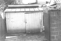
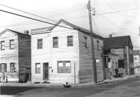
Sheds or garages on site affected by the construction of the Crosstown. Address: corner of Lanier Court and Hanover Street. Surveyor notations on back of photo: "Dkt.: 10.518. Property owner: Bessie Rosen. Tract: 41. Station: 44+40 Rt. N.B. lane Route 17. Date: Mar. 6, 1963." [See collection description for explanation of surveyor notations.]
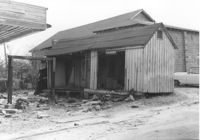
M&F Food Store on site affected by the construction of Interstate 26 (I-26). Address: 14 D Street. Surveyor notations on back of photo: "Dkt.: 10.517. Property owner: Frank Lea. Tract: 13. Station: 5944+55 Rt. - Line 6. Date: February 21, 1963. In R/W - Bought." [See collection description for explanation of surveyor notations.]
House on site affected by the construction of Interstate 26 (I-26). Address: 8 D Street. Surveyor notations on back of photo: "Dkt.: 10.517. Property owner: Lawrence Felder, et al., Est. Tract: 14. Station: 5945+40 Lt. Date: February 21, 1963. In R/W - Bought." [See collection description for explanation of surveyor notations.]
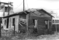
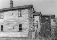
Dilapidated dwelling on site affected by the construction of Interstate 26 (I-26).Address: 6 D Street. Surveyor notations on back of photo: "Dkt.: 10.517. Property owner: Lawrence Felder, et al., Est. Tract: 15. Station: 5945+60 Lt. Date: February 21, 1963. In R/W - Bought." [See collection description for explanation of surveyor notations.]
Dilapidated dwelling on site affected by the construction of Interstate 26 (I-26). Address: 6 D Street. Surveyor notations on back of photo: "Dkt.: 10.517. Property owner: Lawrence Felder, et al., Est. Tract: 15. Station: 5945+00 Lt. Date: February 21, 1963. In R/W - Bought." [See collection description for explanation of surveyor notations.]
Dilapidated dwelling on site affected by the construction of Interstate 26 (I-26). Address: 4 D Street. Surveyor notations on back of photo: "Dkt.: 10.517. Property owner: Lawrence Felder, et al., Est. Tract: 15. Station: 5945+98 Lt. Date: February 21, 1963. In R/W - Bought." [See collection description for explanation of surveyor notations.]
House (rear view) on site affected by the construction of Interstate 26 (I-26).Address: 7 D Street. Surveyor notations on back of photo: "Dkt.: 10.517. Property owner: Rebecca Finklestein. Tract: 16. Station: 5945+45 Lt. - Line 1. Date: February 21, 1963. In R/W - Bought." [See collection description for explanation of surveyor notations.]
House (side view) on site affected by the construction of Interstate 26 (I-26). Address: 7 D Street. Surveyor notations on back of photo: "Dkt.: 10.517. Property owner: Rebecca Finklestein. Tract: 16. Station: 5945+45 Lt. - Line 1. Date: February 21, 1963. In R/W - Bought." [See collection description for explanation of surveyor notations.]
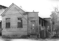
House (rear view) on site affected by the construction of Interstate 26 (I-26). Address: 7A D Street. Surveyor notations on back of photo: "Dkt.: 10.517. Property owner: Hattie Bell Collier Jones. Tract: 17. Station: 5945+65 Lt. - Line 1. Date: February 21, 1963. In R/W - Bought." [See collection description for explanation of surveyor notations.]
House on site affected by the construction of Interstate 26 (I-26). Address: 7A D Street. Surveyor notations on back of photo: "Dkt.: 10.517. Property owner: Hattie Bell Collier Jones. Tract: 17. Station: 5945+65 Lt. - Line 1. Date: February 21, 1963. In R/W - Bought." [See collection description for explanation of surveyor notations.]
House on site affected by the construction of Interstate 26 (I-26). Address: 5 D Street. Surveyor notations on back of photo: "Dkt.: 10.517. Property owner: James H. Anderson, et al. Tract: 18. Station: 5945+90 Lt. - Line 1. Date: February 21, 1963. In R/W - Bought." [See collection description for explanation of surveyor notations.]
Sheds (rear view) and lot on site affected by the construction of the Crosstown. Address: corner of Lanier Court and Hanover Street. Surveyor notations on back of photo: "Dkt.: 10.518. Property owner: Bessie Rosen. Tract: 41. Station: 44+40 Rt. N.B. lane Route 17. Date: Mar. 6, 1963." [See collection description for explanation of surveyor notations.]
House (rear view) on site affected by the construction of Interstate 26 (I-26). Address: 5 D Street. Surveyor notations on back of photo: "Dkt.: 10.517. Property owner: James H. Anderson, et al. Tract: 18. Station: 5945+90 Lt. - Line 1. Date: February 21, 1963. In R/W - Bought." [See collection description for explanation of surveyor notations.]
House on site affected by the construction of Interstate 26 (I-26). Address: 3 D Street. Surveyor notations on back of photo: "Dkt.: 10.517. Property owner: Hattie Bell Collier. Tract: 19. Station: 5946+20 Lt. - Line 1. Date: February 21, 1963. In R/W - Bought." [See collection description for explanation of surveyor notations.]
House (rear view) on site affected by the construction of Interstate 26 (I-26). Address: 3 D Street. Surveyor notations on back of photo: "Dkt.: 10.517. Property owner: Hattie Bell Collier. Tract: 19. Station: 5946+20 Lt. - Line 1. Date: February 21, 1963. In R/W - Bought." [See collection description for explanation of surveyor notations.]
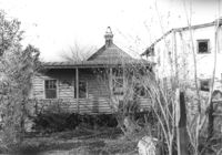
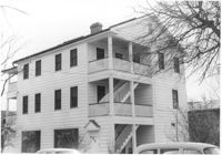
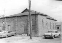
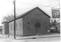
Mount Pisgah Baptist Church (rear view, corner) on site affected by the construction of Interstate 26 (I-26). Address: northwest corner of C and E Street. Surveyor notations on back of photo: "Dkt.: 10.517. Property owner: Mt. Pisgah Baptist Church. Tract: 21. Station: 5946+40 CL - Line 6. Date: February 21, 1963. In R/W - Bought." [See collection description for explanation of surveyor notations.]
Mount Pisgah Baptist Church on site affected by the construction of Interstate 26 (I-26). Address: northwest corner of C and E Street. Sign for Washington Grocery in foreground at right (appears to be across the street). Surveyor notations on back of photo: "Dkt.: 10.517. Property owner: Mt. Pisgah Baptist Church. Tract: 21. Station: 5946+40 CL - Line 6. Date: February 21, 1963. In R/W - Bought." [See collection description for explanation of surveyor notations.]
House on site affected by the construction of Interstate 26 (I-26). Address: 11 C Street. Surveyor notations on back of photo: "Dkt.: 10.517. Property owner: Irene D. Meyers. Tract: 22. Station: 5944+30 Lt. - Line 6. Date: February 21, 1963. In R/W - Bought." [See collection description for explanation of surveyor notations.]
House on site affected by the construction of Interstate 26 (I-26). Address: 43 C Street. (1951 Sanborn map indicates the address is 9 C Street.) Surveyor notations on back of photo: "Dkt.: 10.517. Property owner: R.F. Momier, Est. Tract: 23. Station: 5944+60 Lt. - Line 6. Date: February 21, 1963. In R/W - Bought." [See collection description for explanation of surveyor notations.]
House on site affected by the construction of Interstate 26 (I-26). Address: 43 C Street. (1951 Sanborn map indicates the address is 9 C Street.) Surveyor notations on back of photo: "Dkt.: 10.517. Property owner: R.F. Momier, Est. Tract: 23. Station: 5944+60 Lt. - Line 6. Date: February 21, 1963. In R/W - Bought." [See collection description for explanation of surveyor notations.]
House on site affected by the construction of Interstate 26 (I-26). Address: 7 C Street. Surveyor notations on back of photo: "Dkt.: 10.517. Property owner: Ida Sokol. Tract: 24. Station: 5945+00 Lt. - Line 6. Date: February 21, 1963. In R/W - Bought." [See collection description for explanation of surveyor notations.]
House on site affected by the construction of Interstate 26 (I-26). Address: 37 C Street. (1951 Sanborn map indicates the address is 25 C Street.) Surveyor notations on back of photo: "Dkt.: 10.517. Property owner: Sara Wilson. Tract: 25. Station: 5945+40 Lt. - Line 6. Date: February 21, 1963. In R/W - Bought." [See collection description for explanation of surveyor notations.]
House (corner view) on site affected by the construction of the Crosstown. Address: 86 Hanover Street. View of street corner. Neighboring houses also shown. Surveyor notations on back of photo: "Dkt.: 10.518. Property owner: Ester Bosser. Tract: 42. Station: 43+65 CL line 9 north of Cooper Street. Date: Mar. 6, 1963. In R/W - Bought. [See collection description for explanation of surveyor notations.]
House on site affected by the construction of Interstate 26 (I-26). Address: 37 C Street. (1951 Sanborn map indicates the address is 25 C Street) Surveyor notations on back of photo: "Dkt.: 10.517. Property owner: Sara Wilson. Tract: 25. Station: 5945+40 Lt. - Line 6. Date: February 21, 1963. In R/W - Bought." [See collection description for explanation of surveyor notations.]