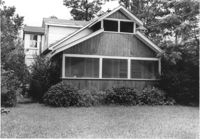
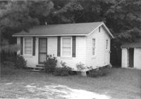
House on site affected by the construction of Interstate 26 (I-26). Surveyor notations on back of photo: "Dkt.: 10.471. Property owner: Jesse Matthews. Tract: 32. Station: 5322+10 Lt. Date: Aug. 23, 1960. Proximity." [See collection description for explanation of surveyor notations.]
House on site affected by the construction of Interstate 26 (I-26). Surveyor notations on back of photo: "Dkt.: 10.471. Property owner: E.D. Smith. Tract: 26. Station: 6+00 Rt. (Ashley Phosphate Road). Date: Aug. 23, 1960. Proximity." [See collection description for explanation of surveyor notations.]
House (rear view) on site affected by the construction of Interstate 26 (I-26). Surveyor notations on back of photo: "Dkt.: 10.471. Property owner: Jesse Matthews. Tract: 32. Station: 5322+10 Lt. Date: Aug. 23, 1960. Proximity." [See collection description for explanation of surveyor notations.]
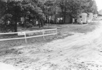
Mobile homes and lot, on site affected by the construction of Interstate 26 (I-26). Surveyor notations on back of photo: "Dkt.: 10.471. Property owner: Mary R. Walker. Tract: 131. Station: 5475+00 Lt. Date: Aug. 23, 1960. Proximity." [See collection description for explanation of surveyor notations.]
Outbuilding (small house) behind house on site affected by the construction of Interstate 26 (I-26). Surveyor notations on back of photo: "Dkt.: 10.471. Property owner: Pauline P. Badger. Tract: 132. Station: 5476+50 Lt. Date: Aug. 23, 1960. In R/W - Bought." [See collection description for explanation of surveyor notations.]
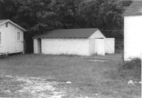
Outbuildings behind house on site affected by the construction of Interstate 26 (I-26). Surveyor notations on back of photo: "Dkt.: 10.471. Property owner: Pauline P. Badger. Tract: 132. Station: 5476+00 Lt. Date: Aug. 23, 1960. In R/W - Bought." [See collection description for explanation of surveyor notations.]
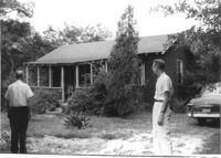
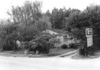
House on site affected by the construction of Interstate 26 (I-26). Sign for Owen's Dry Cleaners at left of photograph. Surveyor notations on back of photo: "Dkt.: 10.471. Property owner: Harry M. Charpia, Jr. Tract: 135. Station: 5377+50 Lt. Date: Aug. 23, 1960. In R/W - Bought." [See collection description for explanation of surveyor notations.]
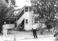
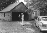
Garage and portion of house on site affected by the construction of Interstate 26 (I-26). Surveyor notations on back of photo: "Dkt.: 10.471. Property owner: Otis H. Schofill. Tract: 35. Station: 5322+00 Rt. Date: Aug. 23, 1960. In R/W - Bought." [See collection description for explanation of surveyor notations.]
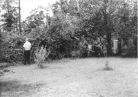
Backyard(?) of house on site affected by the construction of Interstate 26 (I-26). Surveyor notations on back of photo: "Dkt.: 10.471. Property owner: Jesse Matthews. Tract: 32. Station: 5322+10 Lt. Date: Aug. 23, 1960. Proximity." [See collection description for explanation of surveyor notations.]
Dwelling on site affected by the construction of Interstate 26 (I-26). Building address number Apt. 10. Surveyor notations on back of photo: "Dkt.: 10.471. Property owner: Palmetto Flower Corp. Tract: 143. Station: 5479+50 Lt. Date: Aug. 23, 1960. Building No. 7. In R/W - Bought." [See collection description for explanation of surveyor notations.]