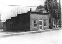
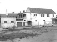
Building, perhaps once used commercially (market?), on site affected by the construction of Interstate 26 (I-26). Building address number 2212(?). Side facade has stepped parapet. Surveyor notations on back of photo: "Dkt.: 10.490. Property owner: F.F. Bellinger. Tract: 88. Station: 5825+40 Rt. Date: March 22, 1962. In R/W - Bought." [See collection description for explanation of surveyor notations.]
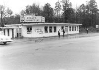
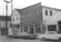
Feran's Superette No. 1, on site affected by the widening of Route 171 (Folly Road). Surveyor notations on back of photo: "Dkt.: 10.494. Property owner: Hula S. Feran. Tract: 55. Station: 178+60 Lt. Date: Mar. 21, 1962. Proximity. [See collection description for explanation of surveyor notations.]
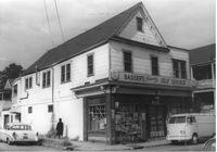
Basser's Friendly Self Service (corner view) on site affected by the construction of the Crosstown. Address: 186 Spring Street. View of street corner. Surveyor notations on back of photo: "Dkt.: 10.524. Property owner: Mona G. Sokol. Tract: 25. Station: 65+60 CL Lt. Date: Oct. 13, 1964. In R/W - Bought." [See collection description for explanation of surveyor notations.]
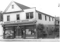
Basser's Friendly Self Service, on site affected by the construction of the Crosstown. Address: 186 Spring Street. Surveyor notations on back of photo: "Dkt.: 10.524. Property owner: Mona G. Sokol. Tract: 25. Station: 65+60 CL Lt. Date: Oct. 13, 1964. In R/W - Bought." [See collection description for explanation of surveyor notations.]
Side of building on site affected by the construction of the Crosstown. Address: 186 Spring Street. (See following two photographs.) Lot across the street in foreground. Surveyor notations on back of photo: "Dkt.: 10.524. Property owner: Mona G. Sokol. Tract: 25. Station: 65+60 CL Lt. Date: Oct. 13, 1964. In R/W - Bought." [See collection description for explanation of surveyor notations.]
Building, on site affected by the construction of the Crosstown. Address: 207 Spring Street. Sew-U-Save Shop. Surveyor notations on back of photo: "Dkt.: 10.524. Property owner: Olympia Papaeilidow. Tract: 167. Station: 20+35 Rt. Spring Street. Date: Dec. 2, 1964." [See collection description for explanation of surveyor notations.]
Right of way--South Carolina--Charleston County, Highway planning--South Carolina--Charleston County, Commercial buildings--South Carolina--Charleston County, Vernacular architecture--South Carolina--Charleston County, Lost architecture--South Carolina--Charleston County, Grocery stores--South Carolina--Charleston County✖[remove]26
Charleston County (S.C.)--Buildings, structures, etc.✖[remove]26